Houston will now warm up before another front arrives on Sunday

Summary: Houston’s temperatures are in the 40s this morning, but this will be the last time until Monday as a decidedly warmer pattern sets in. It will also eventually become wetter, with some decent rain chances on Saturday and Sunday ahead of the front. Our highs will be the in the 70s before conditions turn colder on Sunday night.

Also, as a programming note, we wanted to answer a question that a lot of people have been asking about the ‘polar vortex.’ There has been a lot of chatter online about whether we’re going to experience another outbreak of Arctic air in Texas at the end of this month. Look for a post later this morning by Matt to address these concerns. The short answer is that we don’t see a particularly hard freeze coming at this time.

Most of Houston is in the 40s this morning, but this will be the last time until at least next Monday. (Weather Bell)

Wednesday

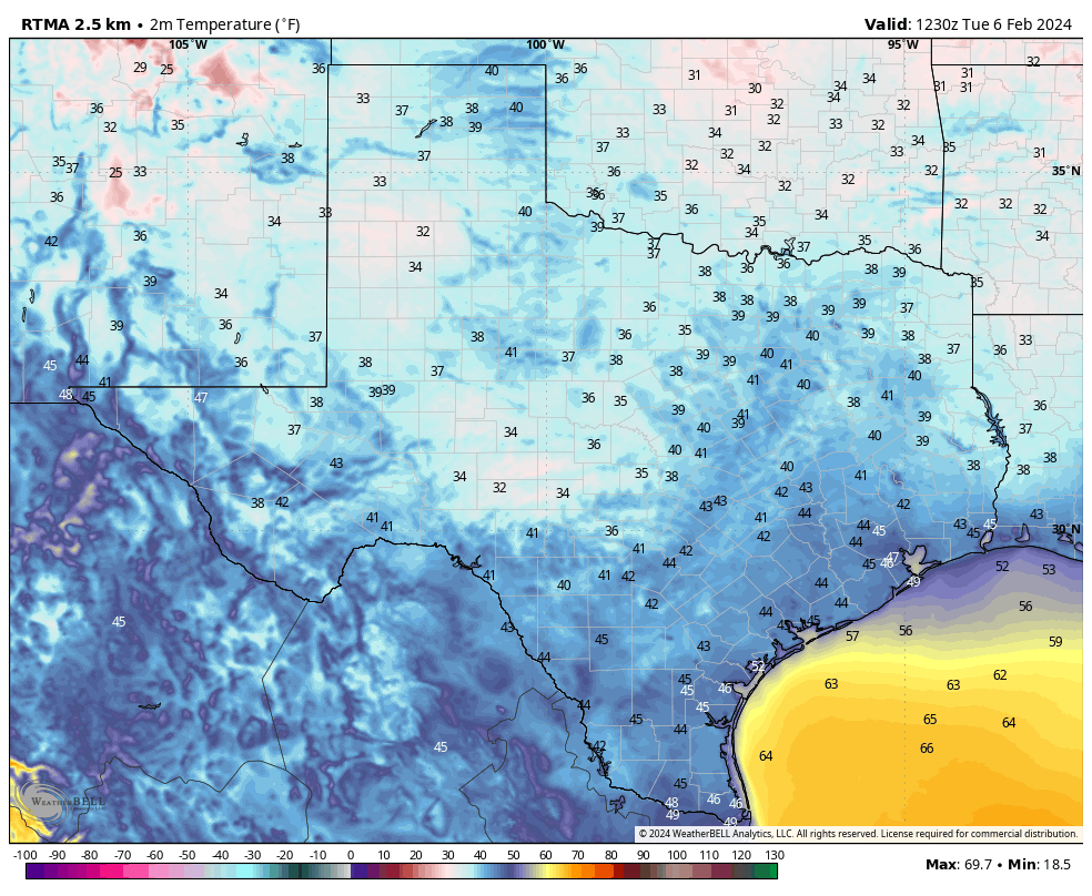
Temperatures this morning are generally in the 40s, with the usual few outliers. Conroe is in the upper 30s, and it looks like Galveston will remain at about 50 degrees. However, with winds from the southeast we’re already seeing the beginnings of an onshore flow that will bring warmth and humidity into the region. Those winds will turn fairly gusty later today, blowing at times up to 25 or 30 mph.

Skies should be clear this morning, but with increasing atmospheric moisture I think we’ll see partly to mostly cloudy skies this afternoon. We’ll be saying goodbye to the sunshine for awhile. Expect highs in the low 70s, with temperatures on Wednesday night only dropping into the low 60s. Some very light showers may be possible after midnight.

Thursday

This will be a gray and warmish day, with highs in the low 70s. Winds will be from the south, perhaps gusting up to about 20 mph. Some light rain showers will be possible, but any accumulations are likely to be on the order of a few hundredths of an inch. I’d put chances at about 20 or 30 percent, so pretty scattered. Thursday night will be cloudy and mild, in the low- to mid-60s.

Friday

This will be another day a lot like Thursday—gray and warm with low chance of light rain.

Saturday

As the atmosphere turns more turbulent this weekend we’re likely to see an uptick in rain chances. You probably have a greater than 50 percent chance of showers, especially for areas north of Interstate 10, and to the northeast of Houston, including locations such as Kingwood. In terms of accumulations most areas will see a few tenths of an inch of rain, but a few areas may see higher totals. Temperatures, otherwise, will be in the low 70s.

NOAA rain accumulation forecast for now through Sunday. (Weather Bell)

Sunday

This day also looks fairly warm, in the low 70s. Our weather, ultimately, will depend on the rate at which the front slogs through the area. I don’t have great confidence in those details yet, but my sense is that we’ll once again see fairly widespread showers before some cooler air starts to arrive Sunday evening or overnight. Lows on Sunday night may drop to about 50 degrees. We’ll see.

Next week

We’ll see clear skies and colder weather to start next week, with highs in the 60s and lows in the 40s through Wednesday. At this point Tuesday morning looks like the coldest day, with lows possibly dropping into the upper 30s. Some rain chances return later next week, and it’s not clear to me whether we’re going to warm above the 60s. So if 70s and humidity are your jam, enjoy the next few days before somewhat colder air returns.

Today’s weather will be nearly perfect, like I dare you to find something to complain about

Summary: Houston gets about 10 or 15 days of A+ weather a year when there is absolutely nothing to complain about. Today, in my opinion, is one of those days. We’ll still see some sunshine on Wednesday before we transition to cloudier and muggier weather. The weekend should see the return of rain showers, although not something we’re concerned about in the sense of flooding.

This early February morning is starting out chilly across much of the state. (Weather Bell)

Tuesday

For me, at least, it doesn’t get any better than this. After a chilly start, today will bring sunny skies, a high temperature of around 70 degrees, dry air, and a very light northerly wind. It won’t last in Houston. It never does. In fact we’ll see the return of a southeasterly flow tonight, which will spell the beginning of the end of our dry air. Lows will still drop into the upper 40s before a warming trend begins.

Wednesday

With the southerly flow in place, we’ll start to see the formation of clouds on Wednesday. I think there is a chance that the morning skies will be reasonably clear, but at some point tomorrow we’re going to flip the switch to mostly cloudy skies. Highs will get into the low 70s, and lows on Wednesday night will only drop to around 60 degrees. Southeast winds may gust to around 20 mph, helping to usher drier air out of the region.

Thursday and Friday

These will be a pair of mostly cloudy days, with somewhat humid air, and highs in the mid-70s. Winds will be persistently from the south, but only at 10 to 15 mph. The only real question for each day is whether we’ll see any rain. I think there’s about a 20 percent chance of very light precipitation each day.

Saturday and Sunday

The weekend’s weather will be a little more dynamic, unfortunately. For those of you a tad upset about nice weekdays and rainy weekends, I’m afraid I’ve got some bad news for you. Saturday and Sunday will both see a healthy chance of light to moderate rain showers before a front arrives sometime on Sunday to clear things out. We’re looking at highs in the mid-70s on Saturday and, depending on the timing of the front Sunday, upper 60s to 70s on Sunday.

NOAA rain accumulation forecast for now through Sunday. (Weather Bell)

The weekend doesn’t look to be a total washout, but I think there’s probably a 50 percent chance of showers each day, with accumulations of 0.25 to 0.75 inches for most, and a risk of higher isolated totals. So we don’t have any real flooding concerns, but these showers may definitely put a damper on outdoor activities. Lows on Sunday night will probably drop into the upper 40s.

Next week

The first half of next week should bring at least partly to mostly sunny skies, and we’ll see highs in the 60s with lows in the 40s. As the southerly flow returns mid-week Houston will return to warmer conditions, and there’s a signal for some rainfall by next Thursday or Friday. But at that point the crystal ball is starting to get pretty foggy.

Anyway, have a great day everyone. I hope you can steal some time outside. Also, I was just kidding about finding something to complain about. I have no doubt on y’all’s ability there.

Why yes, it has been an extraordinarily wet start to 2024

Summary: In this post we discuss the very wet start to 2024 in Houston. As for the forecast, our skies will turn sunnier later today, and remain so for a few days, with cooler nights. We’ll then warm up through Saturday, with a smattering of rain chances to end the work week, and better odds with a front later this weekend.

Winter rains

We are now a little more than a month into the new year, and I don’t know about anyone else, but my backyard is a swamp. Through this weekend, Houston’s official station at Bush Intercontinental Airport has recorded 10.50 inches of rainfall. In the city’s records, which date back more than 140 years, we have only surpassed that total on two different occasions: 1891 (13.12″) and 1991 (11.73″).

Accumulated rainfall by day for each year since 1950 in Houston. (Space City Weather)

Matt put together the chart above which shows accumulated rainfall, by day, for each year in Houston since 1950. (The chart only includes data for the last 75 years for the sake of visibility). This year is shown in dark black. The year which sticks out like a sore thumb, of course, is 2017 when we were drenched by Hurricane Harvey.

This year’s rainfall is part of a fairly typical pattern for an El Niño winter, which tends to cause wetter conditions due to the placement of the jet stream. The pattern has produced an enormous amount of rainfall over California in particular this winter, which Matt has explained more deeply on The Eyewall.

Monday

Winds are continuing to blow across the metro area, with gusts up to 30 mph in some areas during the last hour. This northerly flow should start to ease a bit later this afternoon before the winds die down tonight. A few light showers are falling this morning, but they should end soon. With clearing skies this afternoon, highs should reach the mid-60s. Low temperatures tonight will drop into the mid-40s in Houston, with cooler conditions for areas further inland.

Tuesday

This will be a fine, sunny day. Expect light winds, low humidity, and highs in the mid- to upper-60s. Lows on Tuesday night will drop into the mid-40s.

Tuesday morning should be the coldest of the week. (Weather Bell)

Wednesday

With the return of an the onshore flow on Tuesday night, we’ll see a fairly pronounced southerly breeze on Wednesday. This should bring increasing cloud cover during the afternoon hours, with highs topping out at around 70 degrees. Lows on Wednesday night will only drop to around 60 degrees.

Thursday and Friday

The combination of increasing moisture in the atmosphere and a front stalling north of Houston should result in some cloudy and warmer days to end the work week. I think highs will get into the mid-70s, with fairly humid air. Some scattered showers are possible, although I would peg daily chances only at about 30 percent, with slight accumulations.

Saturday and Sunday

Saturday should be warm again, with highs perhaps in the mid-70s, and cloudy skies. After that I don’t have great confidence in the details. At some point a front is likely to move through with some attendant rain showers. My best guess for the timing of this is Sunday morning, but that’s somewhat of a crapshoot at this point. Sunday’s temperatures will be dependent on the timing of the front, so they could be in the 60s or the 70s. I don’t anticipate an enormous amount of rain with the front, perhaps something on the order of a few tenths of an inch in the Houston metro area with the possibility of higher totals north of the city. We’ll see.

Next week

Next week looks cooler, with highs in the 60s, and lows perhaps in the 40s or 50s. But after that I don’t have much confidence in whether we’re dry, or some showers hang around early in the week. We’ll have to iron that out in a future forecast.

Rain and storms overnight give way to a decent Saturday afternoon and a windy Sunday

Summary: Dense fog this morning will give way to some clearing. Rain arrives tonight, heavy at times after midnight and early Saturday morning. Thunder and lightning are likely, and a couple storms could be strong to severe. After an inch or two of rain and some ponding, we’ll see much nicer weather Saturday afternoon, followed by a windy Sunday. Some cooler weather arrives early next week.

Also, we’re going through one of those phases like in December where we have had enough high clouds to occasionally allow for spectacular sunrises and sunsets.

You can always email us or message us photos on Instagram or Twitter or whatnot!

Today

We’ve got a generally nice, calm day ahead. There is some dense fog this morning, so through about 9 AM or so, you may need to contend with that. Tomball visibility is a quarter-mile as I write this, as is Conroe, Wharton, and Colorado County. So give yourself a minute or two extra getting out the door. Otherwise, we’ll see sun and clouds with highs in the low to mid-70s today and a bit of humidity. Clouds become a little more common later, and some showers may begin as early as sunset.

Tonight and Saturday

Look for rain to become a little more persistent or heavier after midnight tonight. Periods of rain and embedded thunderstorms will continue overnight into Saturday morning, and most of it will actually be done before Noon tomorrow. We may even see a return to sunshine tomorrow afternoon.

Anywhere from an inch or two should fall on average across the area overnight and Saturday morning. No serious flooding is expected, but watch for ponding on roads tomorrow morning. (Pivotal Weather)

In terms of rain totals, most will see 1 to 2 inches on average. The Matagorda Bay and Corpus Christi areas will probably see less than that. But this will be another healthy rainmaker for most of the region. We don’t expect much in the way of severe weather right now, but a storm or two could become strong to severe early Saturday. The main issue would be strong winds briefly in those storms. We’ll probably have a fair bit of lightning and thunder though.

Low temps tonight will dip into the low-60s, with highs tomorrow in the 70s. Overall, your morning plans will be dicey tomorrow, but the afternoon looks perfectly fine we think.

Sunday and Monday

Both Sunday and Monday should see a good deal of sunshine, though a few extra clouds may pepper the sky Monday. The big thing you’ll notice are winds and cooler temperatures. Highs will be in the 60s on Sunday and lower-60s Monday, with lows in the 40s and 50s. So we take a step back cooler here. But the wind will be whipping a bit on Sunday. Look for west to northwest winds of 15 to 25 mph and gusts to 30 mph or a bit stronger. Monday should be calmer, though there will be lingering wind over the water.

Tuesday morning will have a little chill in the air with 40s in most spots. (Pivotal Weather)

Rest of next week

After a cool start to the week, we’ll warm back up later next week with temps back into the 70s by Wednesday or Thursday. Our next chance at rain probably arrives next Thursday or Friday. It does appear that a generally wet pattern is expected heading into the second week of the forecast.

It is expected to be generally wetter than normal heading into mid-February, but it’s too soon to say exactly how that will play out. (NOAA)

Exactly what it means is TBD, as these are probabilistic maps, which say that the forecast leans above normal. But in general, it looks like next Friday or Saturday-ish will be our next decent chance at rain. We continue to get questions about mid-month cold chances. As of now, we don’t think anything significant will impact Texas, but we’ll keep watching.