Cold continues for Houston with a chance of freezing rain north of the city on Thursday. Also, a first look at a marathon forecast

In brief: The cold weather we’ve been experiencing for the last 36 hours is here to stay, as we are going to remain quite cold through Friday night. On Thursday and Thursday night we’re going to add a fair amount of rain to the mix, but fortunately this is unlikely to fall as freezing rain in Houston. The weekend looks sunny and pleasant, at least.

Cold update

Temperatures this morning have, again, fallen to just below freezing for much of the Houston area. The city’s official low temperature this morning is likely to be about 30 degrees at Bush Intercontinental Airport. This is not near record territory, as the record low temperature for January 7 in Houston is 19 degrees, set in 1970.

However, both our daily high and low temperatures are running 10 to 15 degrees below normal, and what is unusual about this week’s weather is its sticking power. We’re going to remain quite cold, weather-wise, through Saturday. So if you received an ugly sweater for Christmas, at least you’re going to be able to put it to good use.

Tuesday

After the cold start this morning we will see sunny skies today, and this should help push high temperatures up to around 50 degrees. Believe it or not, this could be the warmest we get until at least Saturday, which will be the region’s next truly sunny day. Anyway, winds will be lighter today than on Monday, so it will feel less chilly outside. Low temperatures tonight will probably be 1 to 3 degrees warmer than Monday night, so a light freeze is still possible in the Houston metro area, but it’s not guaranteed.

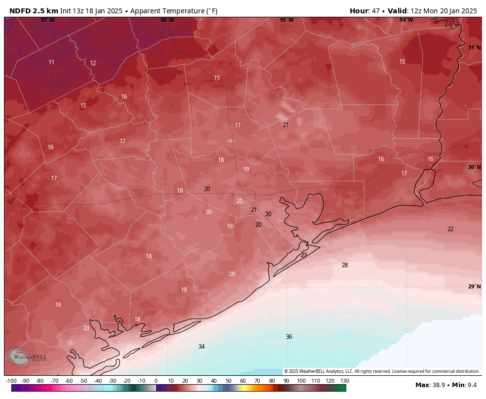
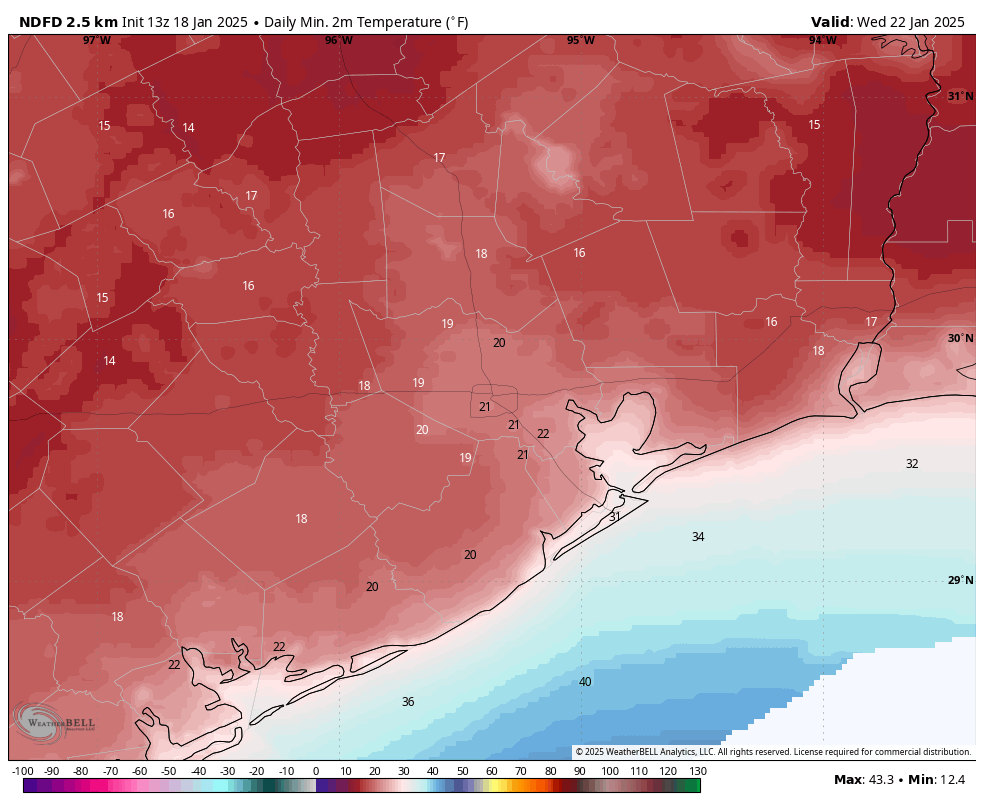
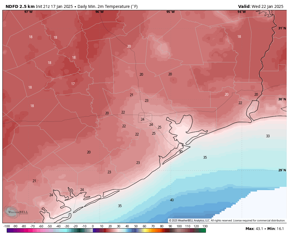
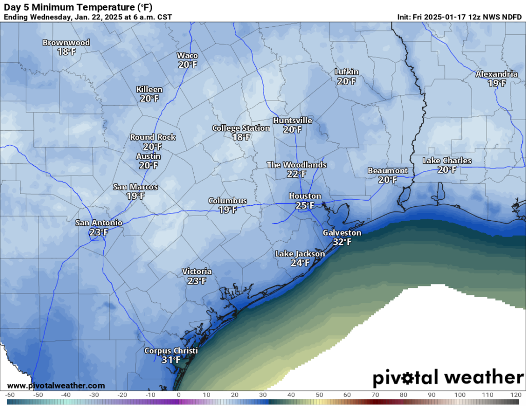
Low temperatures on Wednesday morning should be a bit warmer in Houston. (Weather Bell)

Wednesday

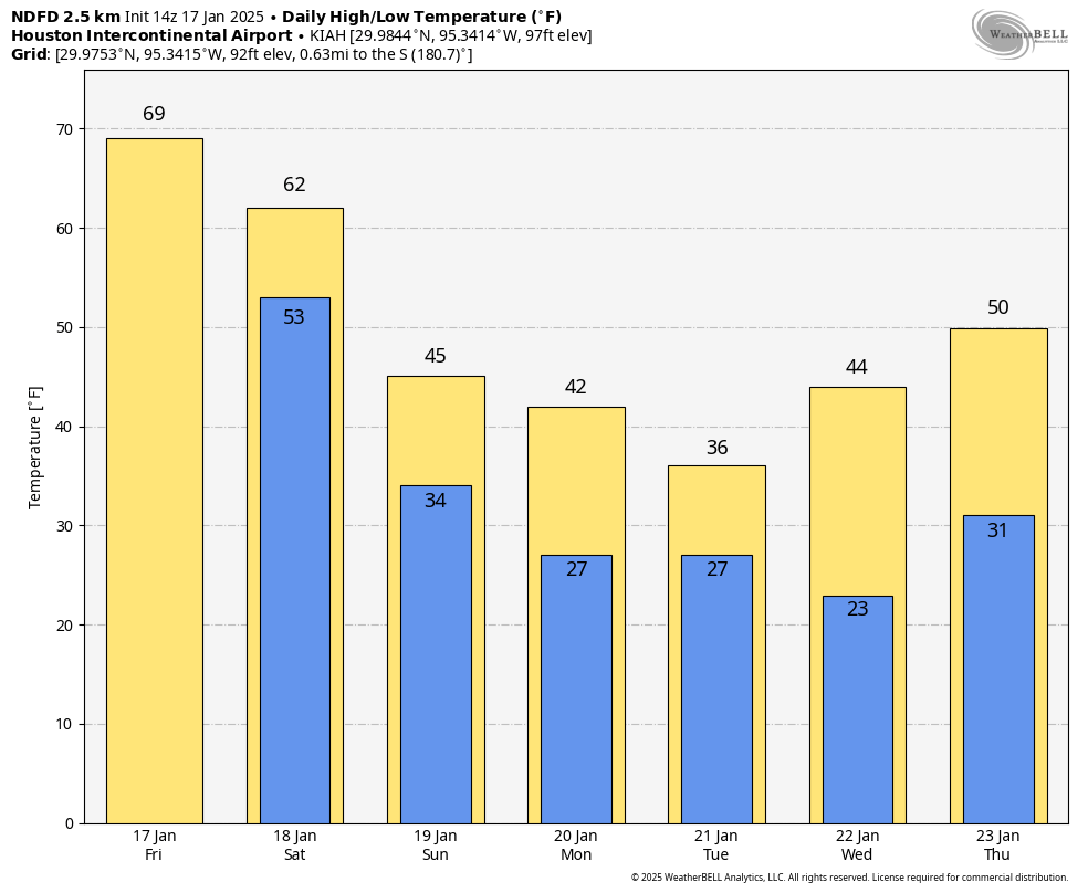
This will be a colder day, as winds from the north increase a bit, with gusts up to 20 mph, and we see the development of some clouds. These clouds should limit highs in the mid-40s during the daytime, but also moderate nighttime highs just a bit. Most of Houston probably will only fall into the mid- to upper-30s. That’s a good thing because beginning early Thursday we’ll start to see some rain chances.

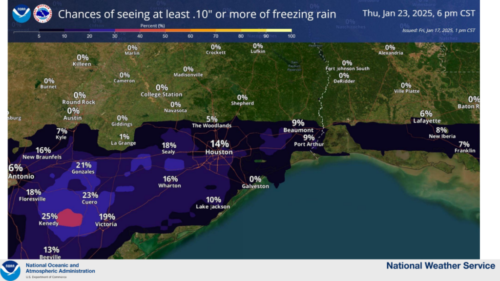
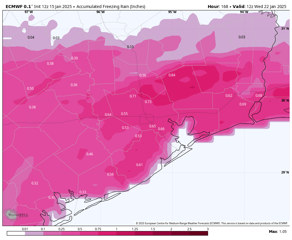
Now I know some people will be disappointed that temperatures are not a few degrees colder, giving us the chance of snow. But I have to say, if temperatures were freezing—given the atmospheric profilewe probably would be getting freezing rain rather than snow in Houston. And let me tell you, that’s miserable, and it’s a mess on roads, and it can stick to powerlines and snap them and … well, freezing rain sucks. So let’s be glad it’s unlikely to fall here. There is a slight chance of freezing rain for counties well north of the city of Houston, including Houston (which is north of Huntsville, Texas) and Trinity counties.

Thursday

This will be a cold and gray day, with an increasing chance of showers the later we go. Like, please don’t plan any outdoor activities for Thursday or especially Thursday evening. Temperatures will be in the 40s, and winds from the northeast at 15 mph with higher gusts. And then there’s the rain. I expect much of the area to pick up 1 to 3 inches of rainfall through Thursday night, with some higher totals possible. So yeah, it’s going to be cold and wet and icky. The rains will continue into Friday morning. As noted yesterday, a winter storm is likely in North Texas, including the Dallas-Fort Worth metroplex. Avoid traveling there if possible.

Rain accumulation forecast for Thursday and Thursday night. (Weather Bell)

Friday

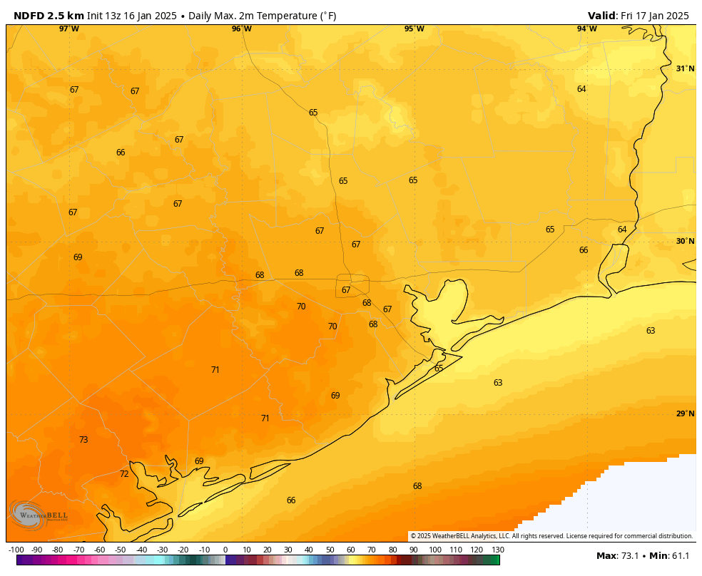
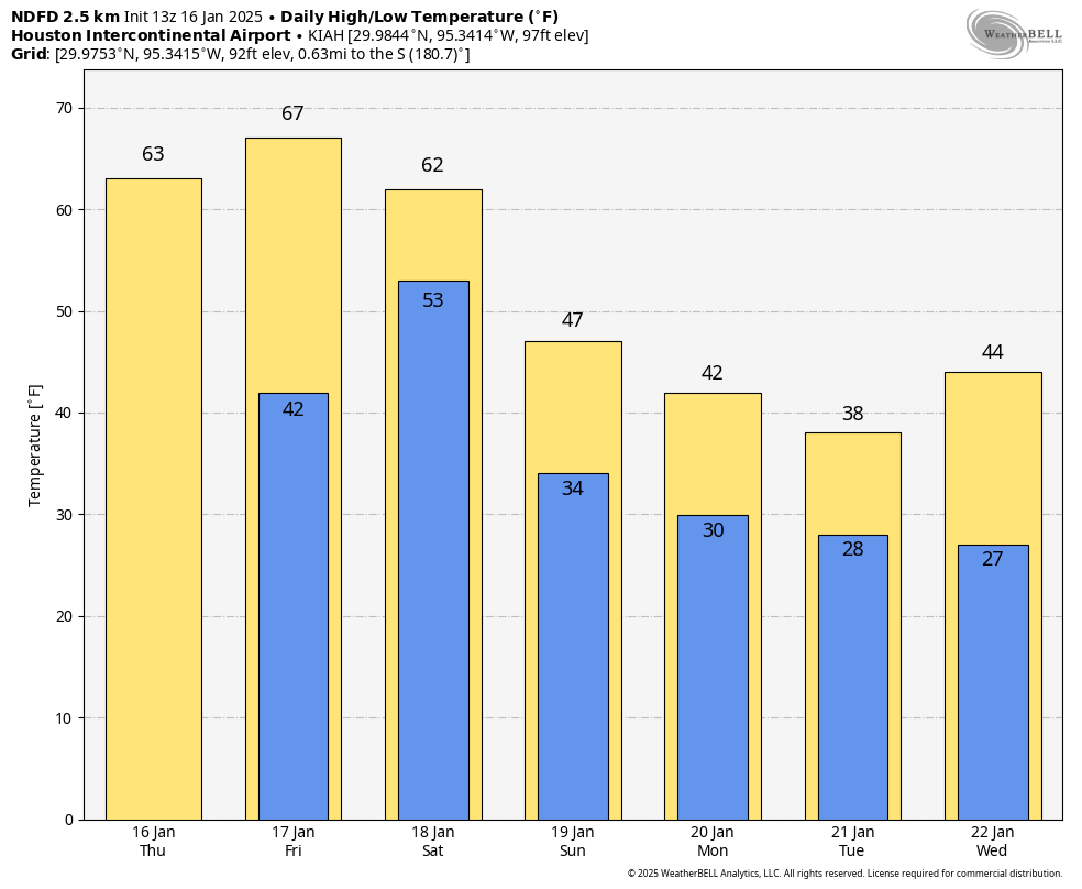
Some rain chances linger on Friday morning before the coastal low pressure system finally clears out. Afterward expect highs in the 40s with mostly cloudy skies. We probably will see an influx of colder air as the low moves to the east on Friday, so lows on Friday night may drop back into the lower 30s on Friday night, with some parts of Houston again seeing a light freeze.

Saturday and Sunday

Sunshine should finally return for the weekend, allowing high temperatures to reach maybe the lower 50s on Saturday, and even the 60s on Sunday. We have no real weather concerns for the weekend, so it’s something to look forward to as we’re freezing this week.

Houston Marathon

Hello, fellow runners. We’re now just 12 days away from the Houston Marathon, and we can begin to take a peek at the weather for the event. I know opinions vary, but I love cold and dry conditions. Some of you like it much warmer and even muggier. So what can we expect?

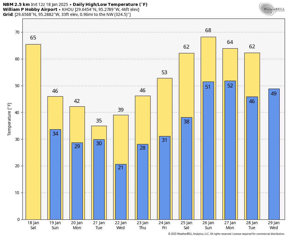
Most of next week looks to remain fairly cold. Not as cold as this week, but with lows consistently in the 40s, and possibly even 30s on some nights. However things may start to warm up some about 10 days from now. At that point there is a pretty broad divergence in the models about whether another system comes through to keep the chill going, or whether we continue to see warmer and milder weather.

So I think we cannot say much sensible about the weather yet for the marathon. It might be 40 degrees on the start line, or it might even be 60 degrees. Rain is definitely a possibility, but it’s way, way too early to make any kind of a prediction there. I’ll update the marathon forecast when there’s something I’m a little more confident in.

It’s been 350 days since it has been this cold in Houston. Also, north Texas faces a major winter storm this week

In brief: In today’s post we discuss the city’s first freeze in nearly a year, and how long this cold weather will last. We also dig into the chances for snow or a wintry mix later this week (unlikely in Houston). Finally, our attention will turn toward the Dallas-Fort Worth metroplex, which faces the prospect of a major winter storm in the Thursday timeframe.

Low temperature watch

I realize it may be difficult to remember back to last winter. After a long, long summer I know it is challenging for me. However, if you recall, we had a pretty potent Arctic blast in the middle of last January. The low temperature at Bush Intercontinental Airport dropped to 18 degrees on one night. And on January 20, the temperature reached 29 degrees at the city’s official monitoring station.

If you’re feeling cold in Houston this morning, take a gander at the Panhandle temperatures. (Weather Bell)

Houston had not recorded a freezing temperature since then—until this morning. As of 7 am CT, the low temperature at Bush airport is 30 degrees, with some locations further inland, in places such as Montgomery County, dropping into the upper 20s. Pretty much the entire metro area, bar the immediate coast, has reached freezing temperatures this morning. This very chilly weather will stick with us through Saturday.

Monday

Although it’s very cold outside this morning, by Houston standards at least, there are at least some bits of good news. Winds that had been gusting up to 30 mph, or higher, overnight are starting to come down. We’ll remain a bit gusty through the morning hours before things really quiet down this afternoon. Skies, too, will be sunny today, and this will help push our high temperatures into the mid-40s. What is beneficial for daytime weather, however, is also ideal for cooling down tonight. And with clear skies and light winds I expect that low temperatures tonight will again drop to the levels we’re seeing this morning, if not a degree or two colder. Tonight will be the coldest night of the forecast period. A hard freeze is possible along and north of Highway 105, which runs from Cleveland to Conroe.

Tuesday morning will be the coldest of the week. (Weather Bell)

Tuesday

This will be another sunny day, with high temperatures likely reaching the upper 40s. Winds will be light, from the north. Lows on Tuesday night should be a couple of degrees warmer, with the urban core of Houston probably not quite falling to the freezing level.

Wednesday

We’ll start to see some clouds building on Wednesday, which will help to limit high temperatures to perhaps the lower 40s. So this could be the coldest daytime temperature of the week.

Thursday

A coastal low pressure system will bring a healthy chance of rain into the forecast beginning late Wednesday night, and especially on Thursday. Given the ongoing cold weather, this raises the possibility of snow or, more likely the threat of freezing rain. At this point, for Houston, I anticipate that low temperatures on Thursday morning (probably in the mid-30s) will be just warm enough to preclude the chance of wintry precipitation locally. Additionally, daytime highs in the 40s will be warm enough prevent anything from sticking.

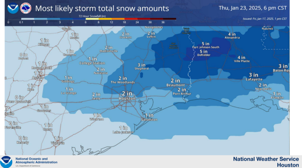
But it’s going to be a fairly close call, and we could see some issues in places like College Station or northern Montgomery County. It’s something we’ll continue to keep an eye on, but again, for Houston, I think this probably just ends up being a cold and rainy day. Most areas could see 1 inch or more of rain. Just think, if it were 10 degrees colder, we could be talking about a foot of snow in Houston! Lows on Thursday night should drop into the mid- to upper-30s, which should again be just warm enough to prevent any wet streets in Houston from freezing over. We’ll see.

Friday

This looks to be another cold and gray day, with highs in the upper 40s maybe. Lows on Friday night should be chilly again, perhaps falling to within a couple of degrees of freezing in Houston. Maybe it even gets all the way to freezing again in Houston, I’m not sure.

Saturday and Sunday

The weekend looks sunnier and warmer, with highs in the 50s, perhaps, and lows in the upper 30s or lower 40s. So still cold, but not as cold.

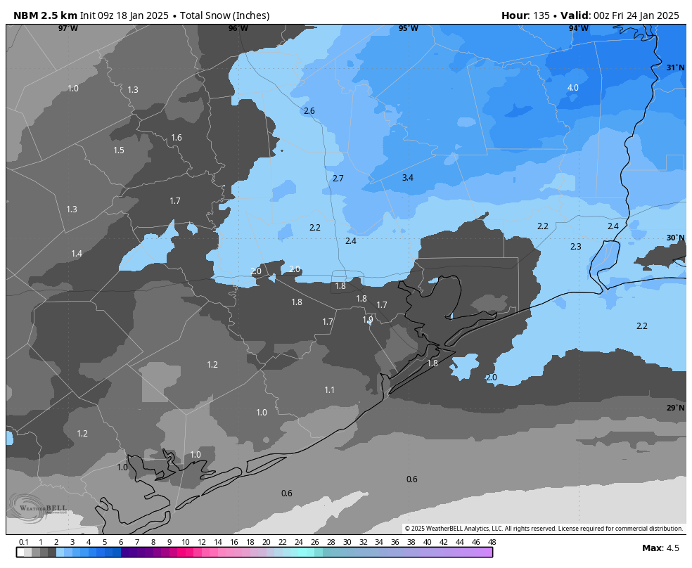
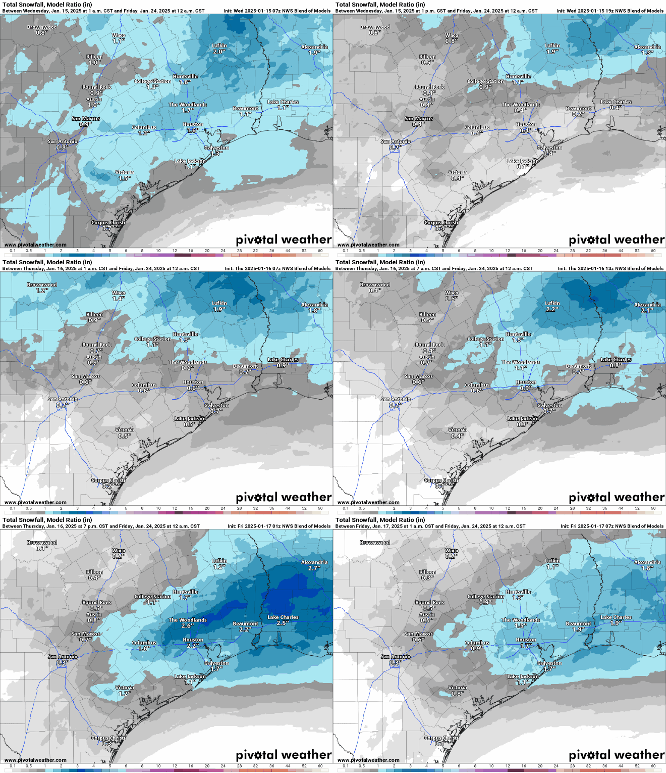
Snowfall forecast, in inches, for now through Sunday. (Weather Bell)

North Texas slop-fest

Although Houston will (probably) be missing out on a winter storm this week, the same cannot be said for areas of north Texas, particularly along the Interstate 20 corridor, and East Texas. These areas will also see a decent amount of precipitation on Wednesday night and Thursday, and it is likely to come in the form of snow, or sleet, or both. I anticipate this will set the stage for a major ice storm on the roads of north Texas, so if your travel plans include Dallas, Fort Worth, or anywhere in Texas north of Huntsville or Austin you’ll need to keep careful tabs on the weather. I don’t think we can say which form of wintry precipitation is coming to north Texas, but something cold and slick is indeed on the way.

Here’s where the freeze line will probably reach on Monday and Tuesday mornings

In brief: The much-discussed Arctic front is on schedule for this afternoon, bringing freezing temperatures to the Houston area after midnight tonight. This post discusses how cold we’re going to get, and whether precipitation on Thursday will just be rain, or something else.

Cold coming

The first few days of the new year have been relatively mild, with high temperatures in 60s and 70s. That will change in a big way later today, with the strongest front of the winter season on track to arrive in the Houston area this afternoon. This front will usher in a freeze to inland areas, including locations such as Katy and The Woodlands, by around midnight. Temperatures should reach freezing for all but areas immediately along the coast by Monday morning. Colder than normal weather will stick around for the remainder of the week.

A good estimate of low temperatures on Monday morning. (Weather Bell)

Frontal passage

Some showers and possibly a few thunderstorms will accompany the front’s passage today as it moves from northwest to southeast across Houston. At present I expect it to reach northwest Harris County by around 2 to 4 pm, and swoop down to the coast by around sunrise. There is a slight chance of some severe weather with the front, especially to the northeast of Houston, in the form of stronger thunderstorms. But mostly, everyone will notice the winds kicking up, and drier air moving in. Temperatures fall pretty quickly behind the front.

The better chance for storms will be to the northeast of Houston. (NOAA)

Monday, Tuesday, and Wednesday

This will be the coldest period, with daytime high temperatures in the 40s. Each night will bring freezing, or near-freezing temperatures throughout Houston. It’s possible that the urban heat island effect could keep some parts central Houston at or just above freezing. But the bottom line is that if you have tender plants, and do not live right on the coast, they are susceptible to freezing.

However, most of the Houston metro area will not face a hard freeze. That is when air temperatures fall into the mid-20s or below, at which point one needs to worry about pipes. So from an infrastructure standpoint, I’m not too concerned about this freeze. A hard freeze is possible for areas along and north of Highway 105.

Low temperatures on Thursday morning will be near freezing, but will it result in snow or sleet? We’ll see. (Weather Bell)

A wintry mix on Wednesday night?

There is still some uncertainty about conditions on Wednesday night into Thursday morning. A low-pressure system is likely to being a healthy chance of rain into the forecast late Wednesday night and into Thursday. Overall we may see as much as 1 inch of rainfall. The question is whether temperatures are cold enough on Thursday morning to support a wintry mix, be it snow, sleet, freezing rain, or what have you. Another factor is when the precipitation starts, as by mid-morning temperatures should be comfortably above freezing.

My sense is that most of Houston probably will just see rain, but that areas inland of Interstate 10 have a chance of seeing snow or sleet. I think it’s a low chance at this point, maybe 10 or 20 percent. But it’s something we’ll keep an eye on considering the potential for mischief with transportation on Thursday morning.

Expect warmer days before a much colder air mass arrives Sunday: A freeze is likely and wintry precipitation is possible

In brief: Houston will experience milder conditions until a robust front arrives on Sunday, with the possibility of some severe weather to the northeast of the city as it passes. Afterward we’ll see blustery conditions, with the likelihood of light freezes and, by Wednesday night or so, even the potential for some sleet or snow.

Friday

There’s some light drizzle at a few locations around Houston this morning, but this should soon clear out. We’ll be left with a partly to mostly cloudy day, and high temperatures in the upper 60s or so. Winds will be light from the northwest and temperatures tonight will drop into the upper 50s.

Saturday

A similar day to Friday, albeit a little bit more humid, perhaps a little more sunshine, and a little warmer. Expect highs in the mid-70s. Saturday night will be quite a bit warmer, with lows only dropping into the mid-60s. If you are looking for a mild evening outdoors, this is it.

There is a slight risk of severe weather to the northeast of Houston on Sunday. (NOAA)

Sunday

Sunday will start out warm, and high temperatures will likely reach the lower- to possibly mid-70s before a front comes sweeping down from the northwest. The timing remains a bit uncertain, but this is likely to occur during the afternoon hours. It looks as though a line of broken showers and thunderstorms will accompany the front’s passage, with the greater likelihood of rain, and possibly severe winds, to the north and east of Houston.

Temperatures will drop rapidly behind the front, as brisk northwesterly winds bring in much drier and cooler air. By early Monday morning much of the region will experience a light freeze, with temperatures dropping into the 30 to 35 degree range for most of the metro area.

Monday and Tuesday

This period will bring us our coldest weather of the season, to date. Look for high temperatures in the 40s, with sunny skies. The clear skies will allow for ideal cooling overnight, with temperatures dropping to around 30 degrees in Houston, give or take. We still don’t have a concrete handle on how cold things will get, but I continue to lean toward a “light” freeze rather than a “hard” freeze. This will be less impactful on our infrastructure, but please do keep pets and plants protected during this cold spell.

Tuesday morning could be the coldest one of the week. (Weather Bell)

Wednesday and Thursday

Temperatures remain cold during the latter half of the week, and we’ll need to keep our eyes on a coastal low pressure system that could bring some decent precipitation chances, especially on Wednesday night and Thursday. Depending on whether this system delivers, and how cold temperatures get, we could see some sort of sleet, snow, or other wintry precipitation on Wednesday night or Thursday morning. Saying precisely what, or how much, is impossible this far out. The bottom line is that if you have plans for Thursday they could be a little messy. We’ll see.

About one-third of European model ensemble members indicated the possibility of some light snow by Thursday of next week. (Weather Bell)

Later next week

Temperatures begin to moderate somewhat heading into next weekend, although we still look cool for this time of year, with highs in the 50s and lows perhaps in the upper 30s, give or take. Winter, for the next week at least, is going to feel like winter around here.