Summary: Quiet weather continues through the weekend before we eye up some heat and rain chances again later next week. There’s about a 40 to 50 percent chance we hit our first 90 degree day of the year next week.
Today through Sunday
After a wild Wednesday morning, things calmed down dramatically as expected yesterday. After another cool morning, we should warm back up into the 70s or near 80 degrees this afternoon. Humidity will remain low, and winds will be lighter than Thursday.
For Saturday, look for more sunshine with clouds, morning lows in the 50s, and highs sneaking back above 80 in most spots away from the coast. We should notice a lot more humidity and more clouds around on Sunday. The morning will start out noticeably milder, with low temperatures only in the mid-60s. Expect to see highs in the low to mid-80s under partly sunny skies.
Monday
Things start to change a bit Monday. One thing we will notice is more wind. Breezy conditions set in probably by Sunday but on Monday, they’ll nudge up a little with gusts over 30 mph at times and stronger at the coast and southwest of Houston.
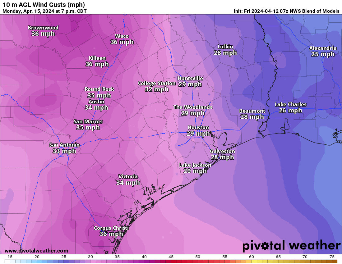
Morning lows will be well into the 60s and highs in the 80s. Rain chances remain low. I do expect to see some additional clouds on Monday, and as is often the case with an influx of humidity in springtime, some showers or sprinkles can’t be entirely ruled out.
Tuesday through Thursday
The chance of rain remains pretty low in the Houston area for most of next week because we expect to see a pretty robust capping inversion in place over the region. This implies that in a layer in the atmosphere, temperatures will actually warm as you go up. This creates what is basically a block in the atmosphere to limit cloud growth and thus reduce rain chances. This is common in spring in Houston and is why we see far less really severe weather than our neighbors to the north and west in the Plains. While things could change, for now expect isolated showers, a slight chance of a thunderstorm, and otherwise partly to mostly cloudy skies into Thursday morning, with increasing rain chances thereafter.
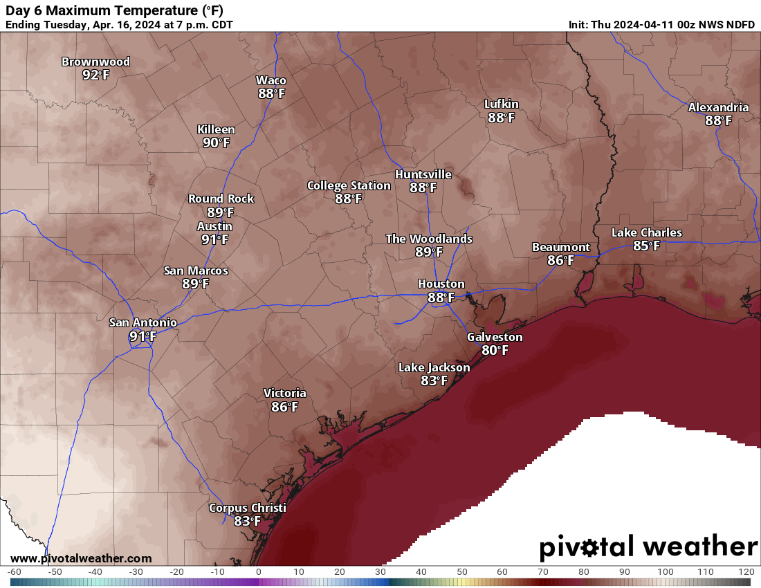
Otherwise, it’s going to get warm with an early summer preview. Right now, we have about a 40 to 50 percent chance to top out at 90 degrees in Houston officially on Wednesday or Thursday. Parts of the Rio Grande Valley should push 100 degrees as well. For Houston, the average date of our first 90 degree day has occurred on April 29th since 1995. We’re getting close.
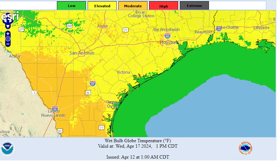
Last summer we started using more charts of “wet bulb globe temperature” (WBGT) instead of heat index. The WBGT looks at numerous factors besides just temperature and humidity and tends to offer a more realistic view of how serious the heat will be for our bodies. Last summer saw numerous days in the high and extreme category. While it will get hot and humid later next week, as of now we’re sitting mostly in the elevated to moderate level for heat. So this will serve as a reminder that summer is coming, rather than feel a ton like summer. I’m mostly showing this today to start getting you comfortable with how these categories work; instead of a number, we see a category. And lots of people continue moving to this area. You’ll be seeing a lot more of this during summer.
It does look like storm chances and front chances will increase late next week or weekend, but we’ll look into that more on Monday.

Thank you and a big ole NOPE to moving toward measuring the temps from the dreaded wet bulb! We are all grateful to having you in or corner especially as we head into hurricane season.
If temps do reach 90, I would expect it be because of an approaching cold front. Good price to pay, I’d say.
Thanks for all the great info!
I LIKE a few clouds. Blue sunny sky reminds me of the coming heat dome.
I’m now retired and try top fish as much as humanly possible. The only thing that will stop me is the wind. Hot, cold, rain, snow makes no difference (and I don’t even have a boat!). Change in wind speed and direction is important or me to know, You mention wind when it will play a pivotal part in the overall forecast. I’d lke to see jst a quick daily mention of wind sped and direction if possible.
Thanks! You are my go-to weather guys. I don’t want to pick up any other forecaster’s lame outlook.
I use the NWS site to check wind speed and direction and other stats. You can zoom in on your area by typing in your zip code. forecast.weather.gov
Beautiful walks in the park yesterday and today! Like you said in your write up this this week, I will really miss this wonderful Spring weather—I’m sad to see it end.
What’s the latest on possibly more drought this summer?