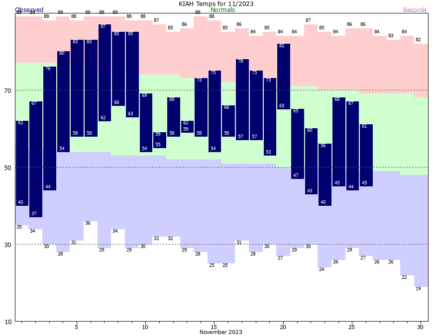
Good morning. Low temperatures have dipped into the upper 30s for much of Houston outside the urban core, and away from the coast. With chilly conditions expected for the remainder of November, it looks like this month will be the first one since May to record a below normal temperature.
The average temperature so far this month—calculated by adding the daily high and low, and dividing by two—is presently a little less than 63 degrees. That will slip a bit this week. It seems notable that while Houston recorded an exceptionally hot summer this year, the spring and fall have been rather temperate.
We’re also in the final days of our annual fundraiser. The response so far this year has been tremendous—thank you so much. There’s still time to buy merchandise or donate if you would care to.
Monday
Our overall pattern this week is fairly straightforward. We face three chilly days and nights before transitioning to a warmer pattern with higher rain chances beginning Thursday. This morning is likely to be the coldest of the week, with lows in the upper 30s. With partly cloudy skies, temperatures will be slow to warm, but we should eventually get into the upper 50s today, with light northerly winds. Low temperatures on Monday night should be a degree or two warmer than Sunday night.
Tuesday
This is the one day this week when we’re pretty much guaranteed sunshine, so be sure and soak it up. The combination of sunny skies and a more easterly flow should allow highs to reach the low 60s. Tuesday night will, in turn, be a degree or two warmer than Monday night, with lows likely dropping into the low 40s for much of the metro area.
Wednesday
With winds becoming more southeasterly, we’ll see a more humid flow beginning later on Wednesday, but it will take some time for the air mass to modify. As a result, I expect partly sunny skies on Wednesday, with highs in the mid- to upper-60s. As the Gulf of Mexico air moves in, we should see more clouds on Wednesday night, with lows dropping only to around 60 degrees.
Thursday and Friday
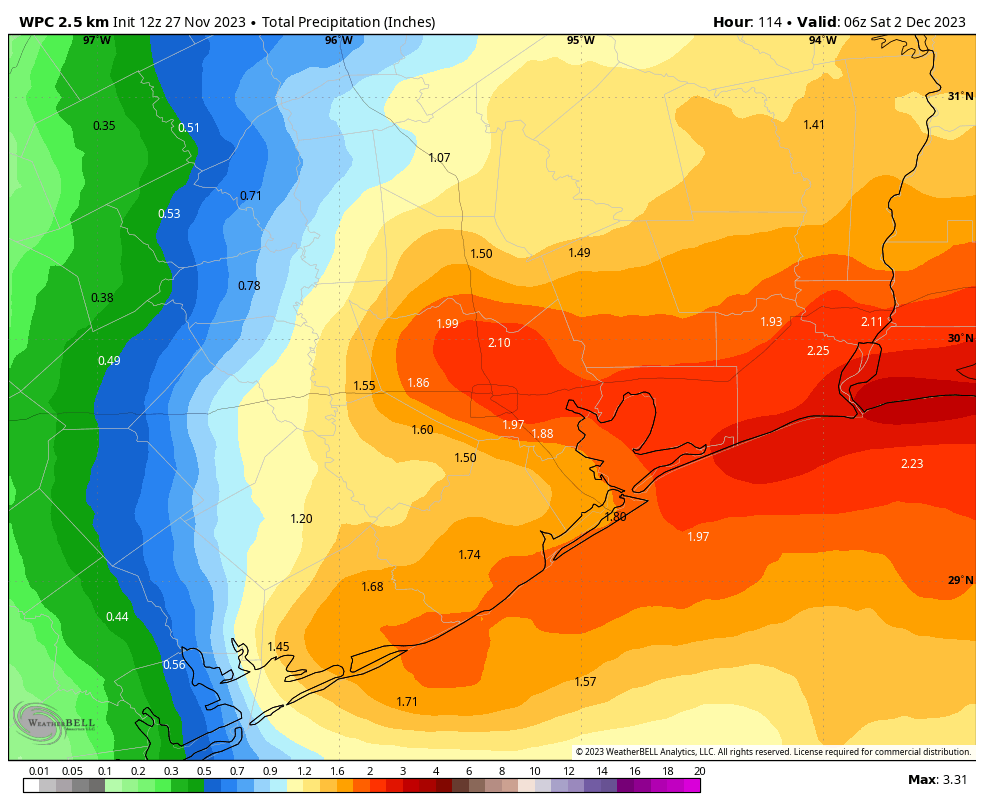
A low-pressure system will driver higher rain chances toward the end of the week, with Thursday likely to be the wettest day. Much of the area could see 1 to 2 inches of accumulating rain on Thursday. This should not be enough to cause flooding, but it should make for a fairly dreary day. Highs will be about 70 degrees. Rain chances continue Thursday night, and still should be 30 to 50 percent on Friday. This will be another warm day with a decent amount of humidity, with highs around 70 degrees.
Saturday and Sunday
The forecast for this weekend is somewhat uncertain as a cold front advances toward Houston on Friday, and then probably moves just off the coast. Our temperatures and rain chances are going to be dependent on the position of this front, and I’m just not entirely confident how far it pushes offshore. So for the time being, I’m going to predict high temperatures in the upper 60s this weekend, with lows somewhere in the 50s. Rain chances will be pretty decent for coastal areas, but likely less for inland areas. All of that is subject to change, of course.
Next week
Given the uncertainty over the weekend, I don’t feel strongly about next week’s outlook either. I do think we’ll probably see some clearing skies by Tuesday or so, and some slightly cooler weather thereafter. But we shall see!


Also might be the first month since last November with a below average temperature at Hobby Airport.
Will the weather on Thursday and/or Friday be severe for the Houston Metro area?
Thursday and Friday
A low-pressure system will driver higher rain chances toward the end of the week, with Thursday likely to be the wettest day. Much of the area could see 1 to 2 inches of accumulating rain on Thursday. This should not be enough to cause flooding, but it should make for a fairly dreary day. Highs will be about 70 degrees. Rain chances continue Thursday night, and still should be 30 to 50 percent on Friday. This will be another warm day with a decent amount of humidity, with highs around 70 degrees.
Thank you for the copy/paste…however several other weather outlets are reporting the potential for severe weather for parts of Texas (hail, damaging winds and several tornados) which is my main concern and why I am asking Eric about the potential for SEVERE weather for the metro area, not just “flooding potential”
A low-pressure system will driver higher rain chances toward the end of the week, with Thursday likely to be the wettest day. Much of the area could see 1 to 2 inches of accumulating rain on Thursday. This should not be enough to cause flooding, but it should make for a fairly dreary day. Highs will be about 70 degrees. Rain chances continue Thursday night, and still should be 30 to 50 percent on Friday. This will be another warm day with a decent amount of humidity, with highs around 70 degrees.
Hi Krystal, I’m not Eric or a meteorologist but I’m guessing that as it gets closer to Thursday they will have a better answer on that.
It seems sensationalist to predict damaging winds and several tornados this far out. I’m sure they would have mentioned it if that was more likely.
I don’t want to tell you to 100% not worry but this seems like that thing other outlets do where they hype up events to scare people/get more views.
Just my 2 cents
Hello August,
Thank you, I appreciate your thoughtful reply and hopefully we wont see anything concerning heading this way or anywhere for that matter:)
Regards,
Kay
Per the NWS:
Day 3 Convective Outlook
NWS Storm Prediction Center Norman OK
0118 AM CST Mon Nov 27 2023
Valid 291200Z – 301200Z
…NO SEVERE THUNDERSTORM AREAS FORECAST…
…SUMMARY…
Scattered thunderstorms will develop late Wednesday into early
Thursday over much of southern and eastern Texas. Severe weather
appears unlikely.
and for later in the week:
Day 4-8 Convective Outlook
NWS Storm Prediction Center Norman OK
0354 AM CST Mon Nov 27 2023
Valid 301200Z – 051200Z
…DISCUSSION…
On Thursday/D4, models are in good agreement depicting a shortwave
trough strengthening as it moves into the southern Plains, with
strong height falls over TX and a 70 kt midlevel jet. This wave is
expected to pivot northeastward rapidly after 00Z, with height rises
from the Rio Grande Valley to the ArkLaTex into Friday/D5 morning.
Low pressure will likely develop over northern or central TX during
the day, and will move with the parent trough toward the Ozarks
overnight. Low-level southerly winds will aid moisture advection,
with a warm front possibly into northeast TX and southern AR by
evening. Predictability issues do exist due to numerous showers and
thunderstorms likely to be ongoing throughout the period, focused
east of I-35, which will reduce instability. However, large-scale
ascent will be favorable and so will deep-layer shear, and it is not
inconceivable that areas of severe storms could develop. The threat
is conditional on access to the better instability plume over
southern TX. Given these considerations, predictability is too low
to introduce severe probabilities at this time.
Katy area looks to lose electricity best to have plans for evacuating.
Only about 110 days until spring.
Are you ever satisfied?
In the winter there are no heatstrokes. My one bedroom apartment doesn’t cost me $200 to keep cool so I don’t have seizures. I’m not attacked by wasps. My car tires don’t get wrecked by hot pavement. My migraines are at a minimal. My animals are happier.
The other day you said everyone loves summer. No. Not everyone loves summer. You are by far the most negative voice here man. Everyone is happy to not have the literally KILLER heat we had this year, where yes. People died. Let people enjoy the cooler weather for the love of all things holy.
I just hope this doesn’t mean that it’s going to be in the 80s and humid through most of December.
“Potential for severe weather”… more at 10. Just more sensationalist BS. Oh, and if you weren’t aware, Direct TV about to drop KHOU on Thursday (just in case you didn’t see the crawls during football yesterday)
I’m just sitting here savoring the fact that 70 degrees is “warm”.