Yesterday, Eric touched on the mostly dry forecast for the next week or so. You may be starting to ask yourself if we are heading back into drought. The answer is that we aren’t yet, but a few more weeks like this and we may be starting to discuss it more.
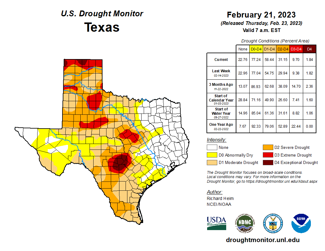
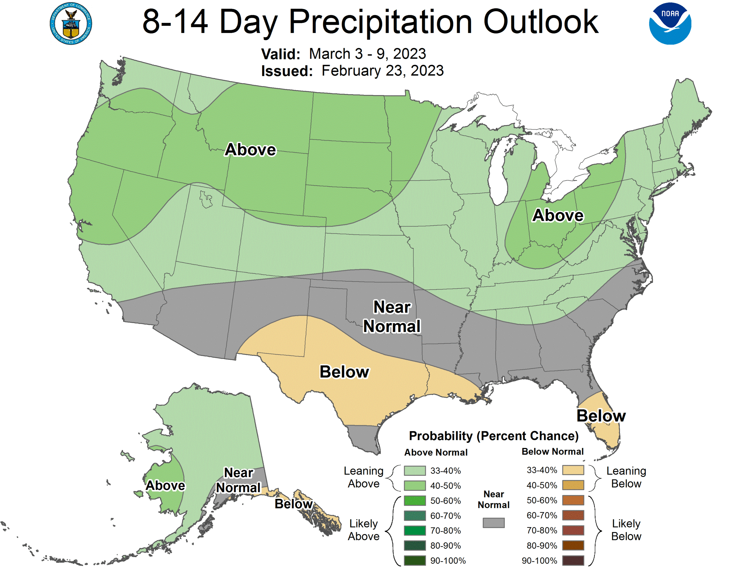
The Houston area right now is fine in terms of official drought. I imagine some farmers are beginning to feel it though across the region. In terms of Texas, about 58 percent of the state is in drought, substantially less than a year ago, so that’s great. But as temperatures begin to heat up and the days get longer, this becomes a little less likely to continue unless we see some meaningful rain. The good news is that parts of North Texas may get a bit of rain, but for the rest of us, it looks less positive. With a mostly dry forecast over the next week and the Climate Prediction Center calling for a dry-ish 8 to 14 day period, expect drought to start entering the vernacular a bit more.
Meanwhile, it hit 83° yesterday, our third consecutive 80 degree day. In February, we’ve done 5 straight days before, in 1986 and 1996. We aren’t expected to hit 80 today, so we will probably end it at three. Just a gentle reminder: These early 80s mean absolutely nothing at all about our later spring or summer. Nothing. So, you may love this or hate this early spring warmth, but it doesn’t mean April or August will go one way or the other.
Today and Saturday
In terms of actual weather, the forecast for today and tomorrow is relatively simple: Clouds, sun, and coastal fog. A passing shower or some light rain, drizzle, or mist is possible as well. We won’t see anything more significant than that.
In terms of temperature and humidity? Yeah, that’s another story. Depending on where you live or where you commute, you may experience both late spring and early spring today. As of 6 AM, the cold front was located basically from Sugar Land through Spring to Lake Livingston.
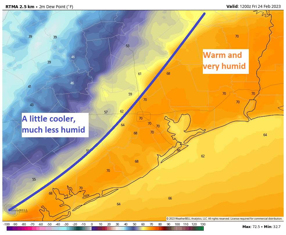
Why does this matter? From a temperature perspective, yes it’s cooler on the other side of the front, but it’s not exactly “cold.” I would expect mostly 60s to low-70s behind the front, while areas ahead of the front do mid to upper-70s today. More importantly, the humidity is sharply lower behind the front. Literally, right now it’s very, very humid at Bush Airport, yet just a little humid in Spring and bordering on comfortable in Conroe. So with this front literally parked over the metro area today, exactly where it’s parked will make the difference between a very warm and humid February day or a mild but somewhat comfortable one. It just so happens that millions of people live around that boundary, so your mileage is going to vary a lot today.
It’s unlikely that this front would get too far south and east today, so most areas south and east of Houston should stay warm and humid with areas of fog or low clouds.
This story continues Saturday. The front is going to move back to the north and west, but exactly how fast and from exactly what start point in the Houston metro area is difficult to say. In general, look for more warm and humid weather to gradually work north and west tomorrow, while coastal areas remain stuck in low clouds and fog. We’ll call it mid-70s for most, but a few places south and east could test 80°, while some places north and west may stay in the 60s to low-70s.
Sunday
By Sunday, the front should finally be making steady progress north. Weather-wise, it will be more of the same: Clouds, sun, and coastal fog. But! Winds on Sunday look a little stronger than Friday or Saturday, so I would hope that we could see the fog get lifted a bit on the coast. Look for a south wind of 10 to 15 mph, or a bit stronger at times over the water. Overall, Sunday should be a mostly cloudy, breezy, and warm day with 80s possible in many spots again.
Monday
Our next real definitive cold front is still scheduled for Monday. There could be an overnight or early morning burst of 20 to 30 mph south winds near the coast ahead of the front Monday, but things will calm down in the morning rather quickly. The front should clear the region by mid-morning Monday with only a handful of showers as it moves through. The rest of the day will actually look gorgeous. Expect sunshine, much lower humidity, and highs in the 70s.
Tuesday & Wednesday
We get our usual bout of cool weather behind the front on Tuesday morning, with lows mostly in the 50s.
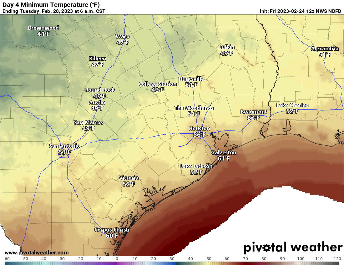
A few 40s may be possible in outlying areas. Tuesday itself looks great with sunshine and highs in the 70s to near 80 degrees. Low, comfortable humidity will continue — a great opening night for the Houston Livestock Show & Rodeo!
Onshore return flow means the humidity comes roaring back on Wednesday. Expect more clouds as well. We’ll test the 80s, and it will feel much less comfortable.
Later next week
Our next front is penciled in for Friday morning. This one should bring some rain and wind (especially offshore) with it, but whether it’s noteworthy or just something you’ll notice remains to be seen. We’ll watch it through the weekend. I’d expect Thursday to be cloudy, warm, and breezy. Friday should be changeable with a chance of early AM storms and gusty winds followed by clearing, much cooler, and drier weather. If all goes well, next weekend will be an absolute winner. Fingers crossed.
Pollen
It’s that time of year, allergy sufferers. This weather is not helping. But the trees are producing heavy pollen this week, and it will only get worse before it gets better. We’re not even close to peak yet, so start prepping now. You can track pollen levels during weekdays via the City of Houston.


For what it’s worth, just north of 99 in far northwest Harris County it was a cool 47 degrees at 6 a.m.
The A/C will likely come on this afternoon. In FEBRUARY. That’s disgusting.
I propose the million of us who live along today’s frontal boundary get outside, join forces, and push it through Houston to the coast so all of the metro area will enjoy the cooler/drier temps and air mentioned by Chris Rimel.
Those of us in SE Houston would greatly appreciate your efforts!
I said a few expletives yesterday on noticing the small amount of pollen on my front door mat. Already??? 🙁
As a farmer, I am glad for this dry stretch. We usually try to start planting corn on Valentine’s day. We got started this past Tuesday. Most our fields are actually still a bit damp. We farm in Fort Bend and Wharton counties. A rain in 8 to 10 days would be perfect.
As a rancher, we’ve been in a drought for 20 years, punctuated by episodes of biblical flood. It’s a tough way to run a business.
Thankfully we may enter an El Nino Winter next year. We usually have more constantly cold winter like weather during those Winters. We may finally start to see some balance from the stupid drought and hot winters return to our weather next year. Fingers crossed.
Should I put away my winter clothes?! That’s all I wanna know