Good morning. As our wet pattern continues we’re in for another rainy 24 hours across the Houston region. But these moderate to heavy showers should fall mostly on the beneficial side of impacts, helping to blunt our emerging drought, rather than provoking significant flooding. Therefore we are lowering our Flood Scale alert to Stage 1.

The primary area of concern today and tonight will be areas southwest and south of Houston, closer to the upper-level low that has been responsible for this wet pattern. Areas south of Interstate 10 could see an additional 1 to 3 inches of rain today, with isolated higher totals, while areas north of there should see less. Some parts of the region may see a break in the showers later this afternoon before a final slug of rainfall this evening and overnight. Rain showers should end by sunrise on Sunday, or shortly thereafter.
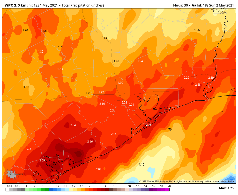
Our region’s bayous and waterways should be able to handle these kinds of rains, but under slow-moving storms we may still see some streets briefly flood. Bear that in mind if you venture out far from home today. If you’re holding out hope for outdoor activity this weekend, Sunday should be a good bet. I expect skies will turn at least partly sunny during the afternoon hours, with highs in the mid-80s.
If this forecast changes, we’ll update accordingly.
Lake Conroe is over the bank up here in the northern part of the viewing area. I would be surprised if there isn’t some water in houses before it starts to drop.
Still only 1″ here for both days. I guess that will keep the grass from dying for another week.
On the news this morning, nobody telling me to stay home, no Eyewitless News mobile units deployed to keep me and my family safe.
So I’m guessing this thing is no longer hypeable for most of us.
4.28 inches at my place in Pinehurst/Magnolia so far With 1.95 inches so far today.
Man! We went from a fairly confident forecast for a nice weekend early last week to posting SCW Flood Scales and having to work weekends. How did that happen? This came out of nowhere. Glad it turned out not to be much of anything other than a lot of wet. Guess I’m going to have to just start reading the next couple of days forecast and ignore the rest…
Upper lows are notoriously difficult to forecast this time of year, and what was supposed to be a progressive system “cut off” from the jet stream and slowed down, hence the big change in weekend expectations. Thankfully the changes began Monday and Tuesday and not Thursday. Five day forecasts aren’t perfect. But some cases are more predictable than others. Not much anyone can do about that.
Plus I don’t put much stock in any forecast beyond three days. Houston weather is to expect the unexpected. That’s always my modus operandi with it.
Check your river level projections. SJRA is releasing from Lake Conroe and so San Jacinto will be at flood stage. They’ve already increased the projection by 4ft since yesterday. Monitor carefully because although Lake Houston has the gates open, they max at 10k CFS, if SJRA releases more than that, it will back up everything. They are at 8500 CFS now, up from 1500 CFS yesterday.
Here’s a good map: https://water.weather.gov/ahps2/index.php?wfo=hgx
4.49 inches in my back yard in the Champions area from 4AM Friday to now, including 1.67″ since midnight. Cypress Creek is not high at all though–I’d say kind of moderate. Unless we get a deluge later it will be fine.
Bear Branch reservoir is high as our backyard is in the floodplain and is mostly flooded still. Not out of the woods yet with another 8-10 hours of rain ahead. The breaks in the rain have allowed it to drain, but tonight’s round hit before it fully drained.