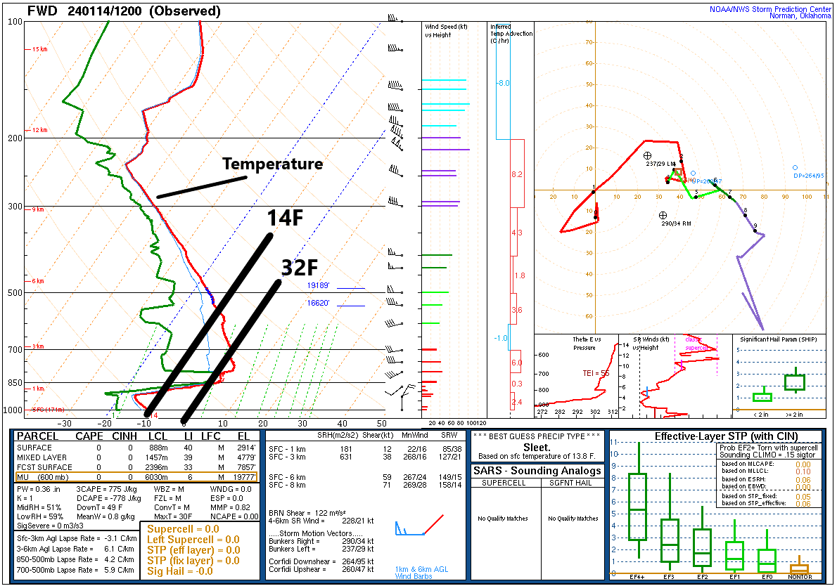
One of the challenges we face as forecasters during Arctic air events is that often times the models are too slow to push in the cold. This type of cold air is shallow and dense (go ahead and insert your jokes here). If you look at a vertical profile of temperatures from Dallas this morning, you can see just how shallow it is. The red line indicates temperature from the surface (bottom of the chart) to the top of the atmosphere. The temperature scale is tilted (skewed) on these atmospheric soundings (called Skew-T plots). But you can see that in Dallas, it was in the teens this morning at the surface. The line that corresponds to “850” on the left says that temperatures were about 34 or 35 degrees at that height, which is about 5,000 feet up. The line skews warmer about halfway there, so the coldest air is only about 2,500 to 3,000 feet deep.
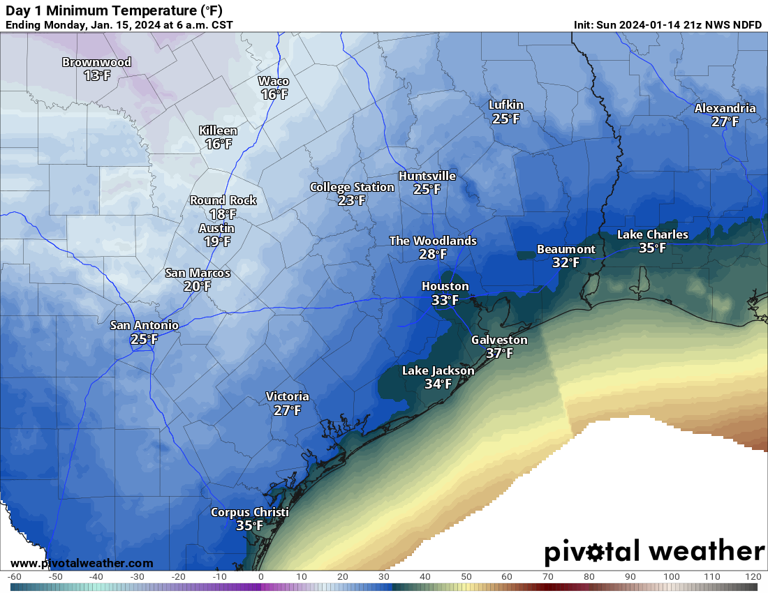
Since the air mass is so shallow, it’s hard sometimes for modeling, particularly the global models we use 3 to 7 days in advance to pick up on how quickly that dense cold air is going to arrive. So based on our experience, we try to account for this by speeding up the arrival time of cold in our forecasts. Every now and then, however, you get a day like today. Temperatures dropped in Houston to about 37 degrees this morning. Meanwhile, as I write this at 3:45 PM, it’s 50 degrees outside. Weren’t we supposed to be cold today? Yes, we had the front stalling at the coast. Instead, it was as warm as 57 in Galveston, 53 at Hobby, 49 at Bush, but only 40 in Conroe and 29 in College Station.
So, the obvious question most of you have is: Does this mean we aren’t getting as cold? No, it does not mean that at all. In fact, very little has changed, forecast-wise today. Once the sun sets, the cold air will resume its southward push, and by tomorrow morning, you can expect temperatures in the 30s in and around Houston and 20s north.
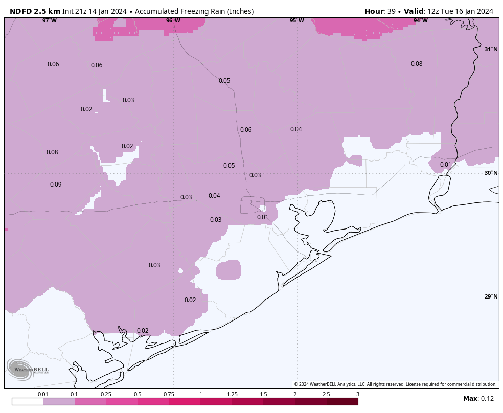
The problem tomorrow is that temperatures will go nowhere. We will stay in the low 30s with some light showers around, and yes that continues to suggest that light icing will be possible. That could begin as early as overnight north and west of Houston, continuing or expanding south and east during the day tomorrow. So, for the Monday holiday, watch for patchy ice north and west in the morning, across the entire area away from the coast during the afternoon and evening. This will not be a widespread major ice storm by any means, but bridges and overpasses will likely have patchy ice across the area tomorrow and tomorrow night, so please exercise extreme caution on the freeways.
I do not want to speculate much at all on Tuesday morning’s commute and school issues right now. That’s above our pay grade, and I would just sort of plan at this point on Tuesday going normally for most folks but have a backup plan in case it does not.
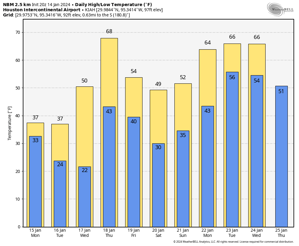
Forecast temperatures are virtually unchanged tonight, tomorrow, and Tuesday into Tuesday night across the area. So we aren’t looking any worse which is good, and this continues to look like a very cold but very manageable event. And if you want warmer thoughts, look no further than the National Blend of Models forecast over the next 10 days. Yes, another freeze is possible this coming weekend, but by all accounts it looks less significant than this first one. But several days in the 60s appear to be in our future. So take solace if you’re too cold.
We’ll have another update for you in the morning!


When should we open cabinets and drip water faucets?
If you are in Houston then you should not drip your water. You should turn it off at the house.
A lot of us live in apartments, and the complexes require residents to drip their faucets and open cabinets. Otherwise we are threatened with being held responsible for repair costs.
If you live north of Houston then tonight may need to start to do that. South would consider tomorrow evening to start.
Thanks for the update !
I love when you guys explain the science behind prediction inconsistencies or your level of uncertainty about events. Very informative and appreciated as always!!
I love space city weather! Thank you Matt and Eric!
I always trust you guys and put a lot of trust in your forecast!
Shallow and dense….I can relate….it’s what most women think of me after the first date….
😂😂
On the app I don’t know how to find The woodlands as a location.
Can you just say close schools just in case 😂😂
How did Eric do?
Looks like he finished in 5 hours, 16 minutes, 41 seconds. Anyone who can finish a marathon has my admiration
Thanks for the info. How was the marathon?
The morning low temperature map shows 25 at Huntsville. Interestingly, it’s already hit 25 at 7pm.
Man, I’m just tuning in to all this. So I can see if I could make it to work on tuesday and wednesday. I’m near the heights and usually take 610 or 45 to bellaire.
I was hoping I would get enough info. So I can cancel my hotel stay near that area. But it seems like I’ll just check into a hotel near bel air tomorrow.
We have understood that the worst of it is monday and tuesday night (pipe wise) for a few days now.
Congrats on another finish today Eric! I ran the half (pretty sure fulls are done for me) and it was great weather. Thanks to your updates, didn’t over-dress.