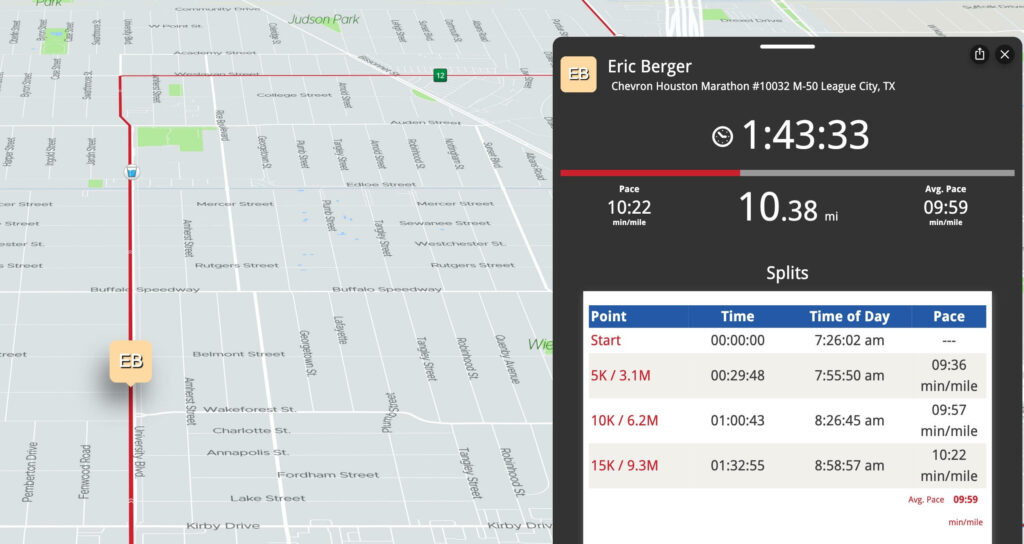
Good morning. I just want to open with a congratulations and good luck to all the marathon runners today. Especially our own Eric Berger!
We’ve been discussing the outlook for this event for a couple weeks now, so it’s nice that for the most part it’s not too bad for a run today. I hope it’s a good day for all!
Winter weather advisory
Weather-wise, we have a couple notable changes to bring up today, mainly in terms of travel tonight and Monday. The chances of patchy ice have increased enough in the Houston area for the National Weather Service to post a Winter Weather Advisory down to Harris and Fort Bend Counties. Essentially, winter weather advisories now cover areas north of I-10 east of Houston and north of US-59/I-69 southwest of Houston.
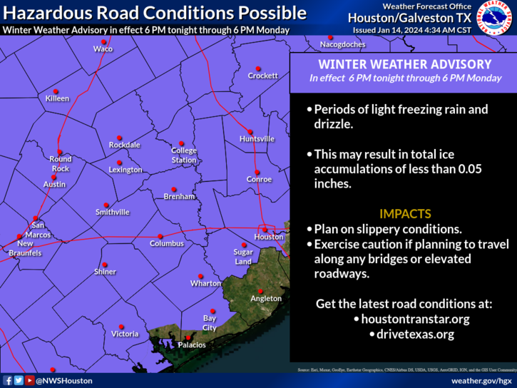
We are not expecting an ice storm in Houston, so let’s be clear about that. What we are expecting is that as temperatures drop back tonight and stay cold on Monday, light rain may produce patchy ice on area bridges, overpasses, and freeway flyover ramps. Given that accumulation is expected to be under 0.05 inches, widespread, major travel problems are not currently anticipated. But if anyone will be out and about tonight, Monday morning, and Monday evening in particular, please take it slow on the roads in case you run into some patchy ice. We don’t want to overstate anything here, but we really do hit on this because it’s not a typical concern we deal with here in southeast Texas. So just drive slowly and cautiously.
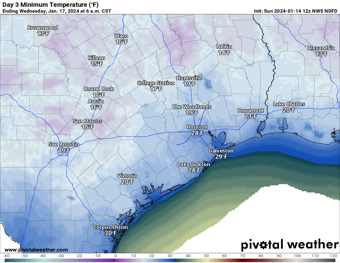
Tonight
Our first night of cold is tonight, and from a “winter so far” point of view, it does not look like anything special here in Houston. North and west of Houston is another story.
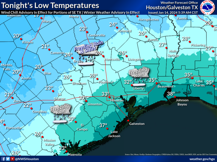
This will be the coldest air of the season so far tonight, with temperatures into the 20s north and west and low 30s in Harris County, slightly milder south and east toward the coast. With light precipitation falling, we’ll see some of that freezing rain or freezing drizzle producing light icing in our area, with some sleet mixed in well to the north and west.
Monday
Temperatures will move very little on Monday. Look for highs to be maybe a handful of degrees warmer than those low temperatures shown above. Precipitation will continue, periodically and lightly, through the day. Light icing risk will continue on bridges and overpasses, especially north and west of Houston.
Monday night
The coldest night of winter so far will settle in here tomorrow night. Look for lows in the mid-20s in Houston proper, low to mid-20s in the suburbs, and milder at the coast/colder north and west. Overall, this is a little bit less cold than initially expected but it’s still plenty cold.
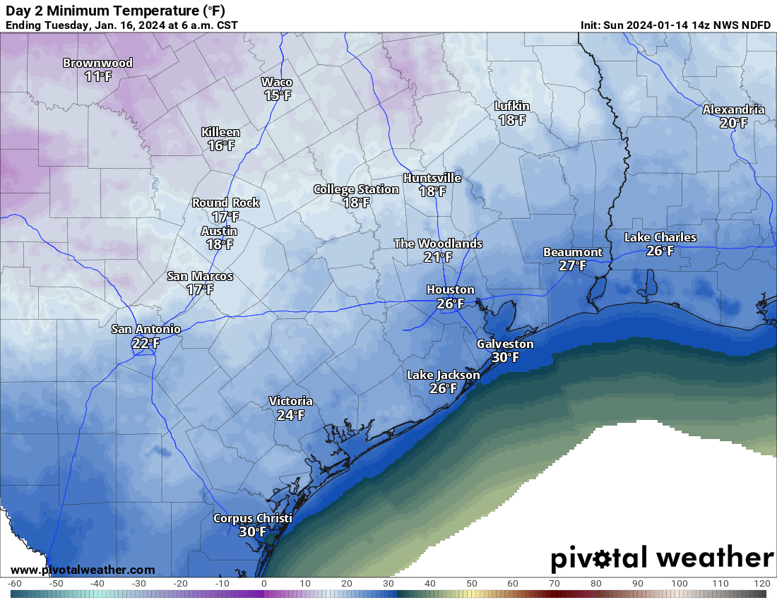
In terms of duration, the city of Houston will probably see about 16 hours of temps near to below freezing Monday night into Tuesday morning. Look for a few hours less than that south and east and more than that north and west.
In addition, brutally cold wind chills will accompany this, with “feels like” temps in the low teens and single digits Monday night and Tuesday morning. Bundle up the kiddos Tuesday morning!
As of right now, icing is not expected to be a serious concern Tuesday morning, but with some lingering precipitation Monday night, I would not rule it out entirely. More on that later and tomorrow.
Tuesday
After the cold morning, the daytime won’t be a ton better. But we should manage low to mid-30s, briefly above freezing. You’ll see the sun on Tuesday too. So that’ll be nice. Wind chills will remain unpleasant all day, but the wind should begin to die off in the later afternoon.
Tuesday night
The coldest night of the event will be Tuesday night. Houston will bottom out in the low to mid-20s, with the suburbs in the low-20s. Areas north and west should dip into the teens. Cold, but manageable is how we described it yesterday, and that’s how I would describe it today as well.
Despite the stronger cold, the duration of temperatures below freezing may be a little less Tuesday night just because we’ll warm up faster Wednesday morning. So look for about 14 or 15 hours in Houston proper. Add to that north and west and subtract from that south and east. Either way, cold preparations need to be in place Monday night and Tuesday night for a hard freeze in the entire area away from the immediate coast.
Wednesday
Break out the shorts, as we’ll see highs well into the 40s and even warmer than that Thursday. More on that tomorrow or Tuesday.
We will have another brief update on things for you later this afternoon, focusing on any forecast changes to the icing risks.


Please be sure to touch on travel between major cities in your afternoon update!
Can you specify when the precipitation will start? The apps all say 0% chance of precipitation and I have a teen that wants to drive somewhere tonight…
PS – thank you for all you do!
😂 lolol, break out the shorts. Thank you for the update
Trends have gotten warmer. And this isn’t no arctic blast/blue norther as we know. winds aren’t roaring like a real arctic blast and low clouds enveloping area keeping temps dropping during day, rain/mist. It’s actually quite pleasant this morning. Leaving plants out to get extra day of sun and will bring em in later today/evening.
Thank you so much for the time and care you put into your forecasts. The twice-daily updates as this weather system evolves are beyond helpful!
Any idea of timing of the freezing precipitation tonight? Needing to pickup daughter at airport around 9:00, or have her get a rideshare
I think your site is THE most accurate available anywhere. I am a devoted fan! There is one thing that I wish you could clarify, however. When you write, for example, that there will be icy weather or whatever west of Houston, could you explain more precisely what west of Houston covers. The Memorial Villages, for example, or places much farther west? That would help those of us or not great at figuring out locations.
I have a stupid question! I live right on the coast on the West end of Galveston, between the beach and the bay! Does one look at actual temperature or feels like temperature when considering our plants and landscaping??? I already have my potted plants inside, but wondering if I really NEED to cover all of my others! The actual temp will be barely freezing here, but feels like will be below!!?
Plants are not affected by wind chill. They are susceptible to wind-aided drying. Giving the soil around them a gentle soaking during warm periods can help alleviate this. Covering them at night, ovr dampened soils, can also help moisture retention and allow for latent heat release to be trapped more efficiently.
Matt,
Thanks for putting this on, most helpful
Basking in 57F and sunny skies in league city. While it’s 29 in Huntsville, and 15 in Dallas at this time.
Thank you for all updates for the weather. Nice to know what to expect in this few days coming up. People, plants, pipes, pets, pools need to make sure they are taken care of.
Just moved here from KC, this feels like home for me LOL. Going to enjoy it for the next couple of days.