Summary: After a wet and at times weird Thursday, the weather will calm down for the weekend. Our next storm aims for us on Monday, with another chance of showers or thunderstorms. Temperatures will remain on the cooler side at night, with mild to warm daytimes.
Quick editor’s note. Look for the second in our Q&A post series later this morning with answers to some of your questions!
Recap of yesterday
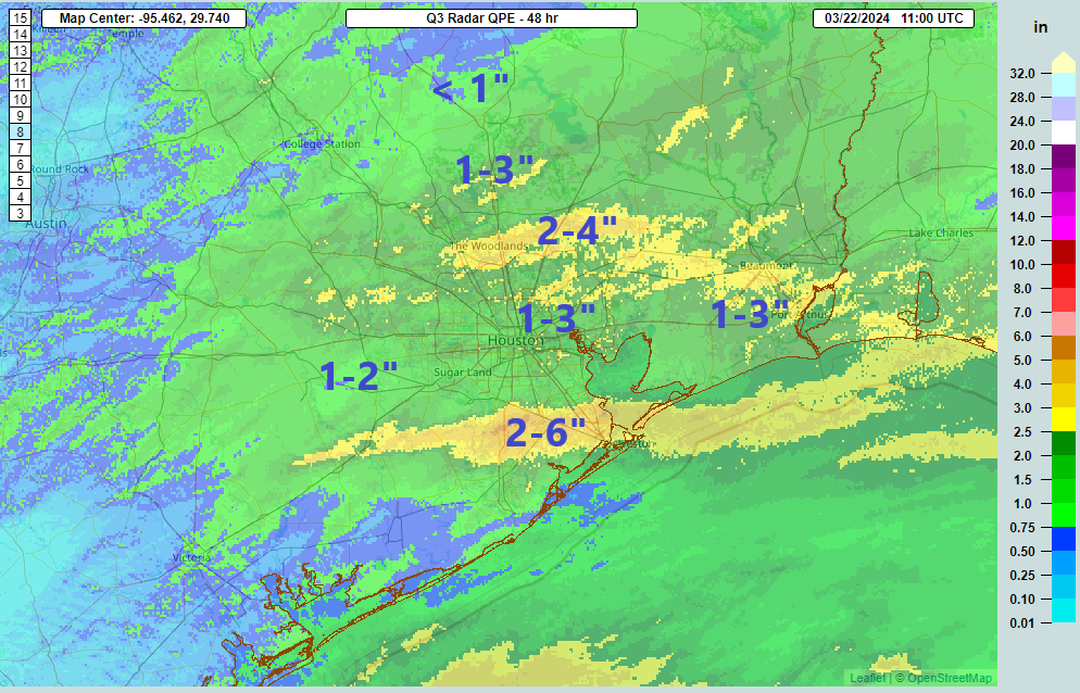
Rain totals yesterday were pretty healthy across most of the region. Between the early day rain in Houston and points south and later day rounds of thunderstorms north of Houston, virtually the entire area picked up a needed 1 to 3 inches of rain, with pockets of higher amounts.
Additionally, we had another couple rounds of hail reports with the evening storms, which felt like they came out of nowhere. If you squinted enough at early day model data, you could see some signals, but in real time, it was a bit difficult to pick out that there would be two additional rounds of storms north of Houston between the AM rain and overnight storms.
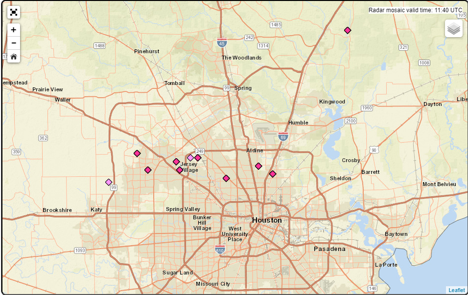
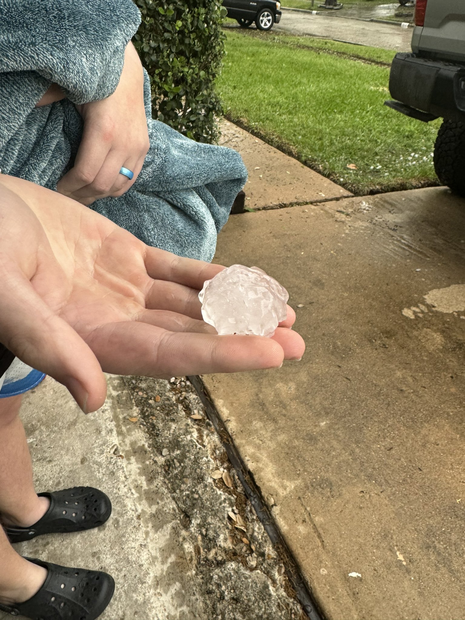
Anyway, we did have some pretty nasty hail north of Houston, with mostly quarter to half-dollar size hail reports from Copperfield through Jersey Village to near Acres Home and the Northside.
We had some additional hail reported north of there after 9 PM, though reports seemed a bit sparser. Then we had one final round of storms around or after Midnight. Those had strong winds and maybe some brief small hail. And absolutely torrential rain. And a gorgeous lightning display as they moved away.
It was a day.
Today and Saturday
We need a little time to dry out now, and we’ll get it today and tomorrow. Clouds should be on the gradual decrease today, leading to a nice afternoon. A couple showers may graze areas northeast of Houston late today as the system responsible for yesterday’s storms exits to the east. Highs will be in the 70s.
Look for sunshine tomorrow with highs well into the 70s after morning lows in the 50s. Splendid weather for the Bayou City Art Festival downtown or Saturday evening’s Houston Dash match with Racing Louisville, among many other activities this weekend. Yesterday’s rain did a number on pollen, but we may see it bounce back this weekend, so just be advised if you’re an allergy sufferer!
Sunday
We’ll transition to a slightly more humid setup as Sunday progresses. Morning lows in the 50s or low-60s would be followed by more clouds than sun at times, with highs in the mid-70s. Onshore winds will nudge up as the day wears on, so you’ll probably notice that also. I wouldn’t entirely rule out an isolated shower late in the day, but the vast majority of us should stay dry.
Monday
Our next system will join us for a limited engagement on Monday. Scattered showers and thunderstorms are likely before a cold front approaches in the evening hours. I don’t want to overstep my bounds of confidence right now, especially given how yesterday evening unfolded. But this storm looks a little less potent than yesterday’s. Still, showers and storms will be possible as early as Monday morning, ending sometime in the evening (though it shouldn’t rain in that entire window we don’t think).
Most areas should see about a quarter to half-inch or so of rain, but I would say this is a bit of a fluid forecast. Check back in either this weekend or Monday to see if anything has changed.
Rest of next week
Much drier air builds in behind Monday night’s front. Dry air in late March allows us to cool off quickly in the evening and warm up quickly in the daytime. Look for highs in the 70s and lows in the 50s, if not a night in the 40s too. But we could easily see a 20 to 25 degree range in temperatures each day. Break out the quarter zips and shorts!

April Ann and Billy think your choice of 7 on the excitable dog scale was a bit low. They think an 8 or 8.5 is closer to where it really was.
I have to agree. Those storms came in hotter, and further south, than I anticipated.
They certainly held together. Expected them to fall apart in the Katy area.
Yeah – went to bed thinking “Lucky to get anything, storms passing well to the north. Then a rude awakening at oh-dark-thirty.
We had a booming storm down closer to the coast at 1 am, too! Quite a surprise!
We lost power for about 45 minutes, around 1 a.m. High wind, heavy rain, amazing lightning. We’re in the very south end of unincorporated Harris County, between Webster and Friendswood.
Any evidence of a quick tornado in Katy last night, just after midnight? It sounded like a freight train coming through! Many neighbors lost trampolines and fences were down throughout the neighborhood.
Where in Katy? We’re just south and east of 99 & I10.
I came here to also say that just before 1am the strong line of storms stretched from the north all the way to beyond Friendswood; and for us in the Ellington Field area of Clear Lake it was scary to wake up to. Ripped a shutter off our house and lost power over an hour and a half. The winds were as ferocious as the lighting was perpetual. It came and went within 30 mins, but it was wild and unexpected down here. I thought only the north was supposed to get it.
I didn’t expect that much wind, and apparently neither did my 6′ fiddle leaf fig, as she decided to break her giant pot all over my porch. 🙁 here’s hoping she survives (picky things!)!
It was very weird, the way that unbroken long line of storms that stretched from San Antonio up to OK, just marched straight east in the later hours; like an elongated singular, organized light show on display, just walking itself across the state.
It didn’t seem to move within the normal patterns. Pretty to look at, but creepy to feel.
🌬 ⛈⚡⛈
Perfect squall line example last night.
2.85″ of rain for the day, Kings River area of Atascocita near Lake Houston. Quite a productive day of storms. Glad I got plants in the ground last weekend. Nice weather this weekend will be working hard to tug me away from March Madness this weekend.
March Madness is a good name for the weather we’ve had this March.
288 and I-45 had quite the light show and 0.6″ of rain in about 10 mins. it was fantastic.
Just under 0.8″ here overnight, I thought it would be a lot more given how hard the rain was being driven into the back of the house. So maybe 1.8″ of much needed rain since Thursday AM.
Problem: Will probably have to cut grass Sunday. Things are starting to green-up.
CenterPoint sent an email update regarding our power outage: “Our crews determined that the problem was caused by a tornado.”
I’m in Kingwood…has this been confirmed?
There have been no confirmed reports of tornadoes.