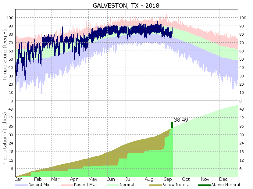
The city of Galveston started September with a 12-inch deficit in annual rainfall, and now, a little more than halfway into the month the city has a nearly 5-inch surplus. The last two weeks have been incredibly wet for the island, and the southern half of the Houston region as tropical moisture has surged into the area.
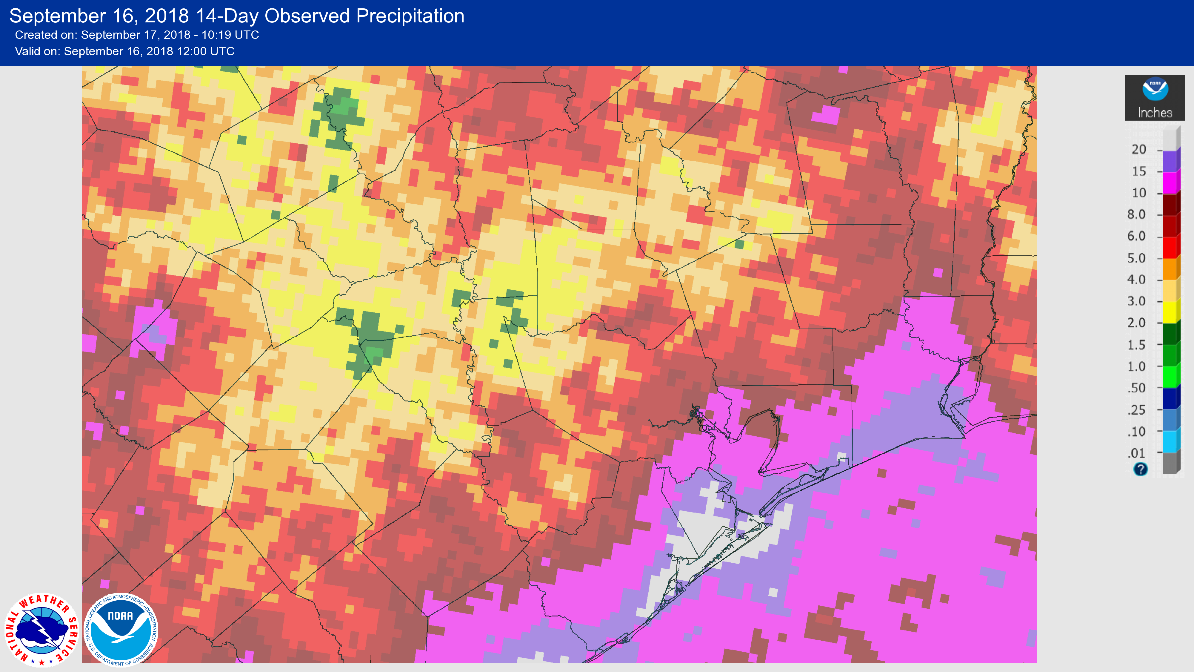
The image below, showing rainfall over the last 14 days, demonstrates how the coastal areas have been inundated, whereas some inland areas have received as little as 1-2 inches. While these rains—in excess of 20 inches for locations along the coast—have caused some flooding problems they have not been too widespread. This is because the region can handle 20 inches of rain over two weeks. It’s the 20 inches of rain in two days that causes major problems.
While we are not done with rainfall entirely, I think it is safe to say we are likely done with the threatening, heavy tropical rainfall for awhile. Good riddance.
Monday
A partly to mostly sunny day today, with only isolated to scattered showers later during the afternoon hours. The sunny skies and lack of precipitation should allow temperatures to nudge up into the mid-90s for most parts of the Houston region. Summer, alas, is not quite ready to loosen its grip.

Tuesday and Wednesday
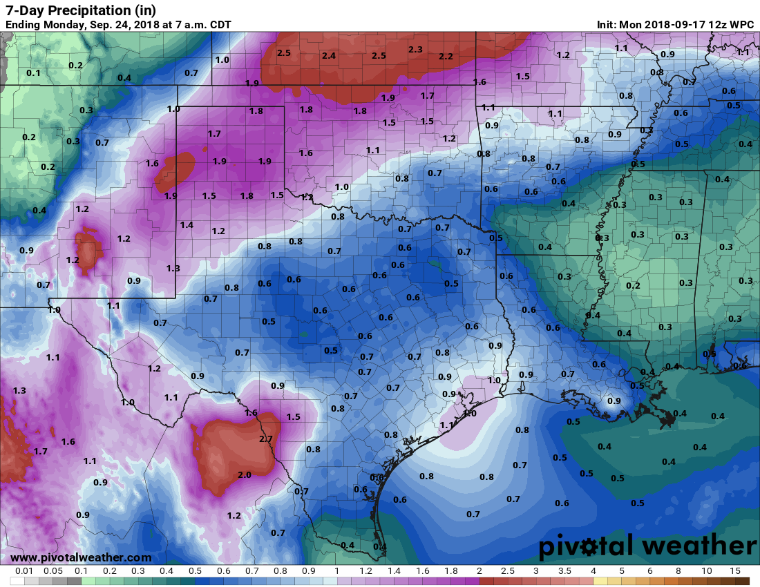
I’d expect a slight increase in rainfall coverage toward the middle of the week as high pressure moves away, slightly. We’re probably looking that the typical 30 percent chance of afternoon showers and thunderstorms. Highs probably will fall back into the lower 90s with a bit more cloud cover.
Thursday, Friday, and Saturday
Moisture levels appear likely to creep back up heading into the weekend as high pressure moves off, and opens up the region to more of a flow off the Gulf of Mexico. Temperatures will fall back, possibly into the upper 80s, and rain chances will increase to about 50 percent each day. Forecast models aren’t advertising anything too extreme right now in terms of rainfall, and most of the region is probably looking at between 0.5 and 1.0 inch through Saturday or so. But that may be enough to put a damper on some outdoor plans.
Sunday and beyond
Rain chances likely fall off some on Sunday, and this certainly seems to be the better day for outdoor activities at this point. It looks like we’ll remain in a late summer-like pattern with a chance of afternoon showers for a while into next week. As for the region’s first fall cold front, nothing immediate appears to be on the horizon. We’ll dig a little deeper into the climatology of Houston’s first front tomorrow. We’re not late for it—yet.
Is Isaac dead yet?
We’re continuing to see questions about former Hurricane Isaac, which is now a remnant low pressure system in the Caribbean Sea near Jamaica. The National Hurricane Center gives it a 10 percent chance of development into a tropical depression or storm during the next five days.
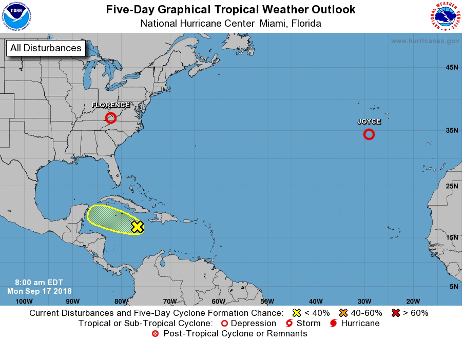
At present, it is showing no signs of organization, and none of the really important global models show much (if any) indication of organization over the next several days as this “system” tracks toward the Gulf of Mexico. We’re watching the remnants of Isaac, but at this point, at least in reference to Texas, we’re not losing any sleep.
When it comes to Texas?
I think that phrase means, “regarding Texas,” not “when Isaac comes to Texas.”
Correct!
Phrasing! Changed it for the purposes of clarification.
Can we do a Space City Weather naming of cold fronts!?
I’ll start, when will we see Cold Front Ahhhhh
Followed by “Cold Front Oooh, it’s Fall Crafts Festival Time” and “Cold Front Wear a Jacket to Friday’s Game”
Interspersed with “Shoot, Not Yet” and “Wearing Shorts on Christmas Day”.
Can you speak to the effects of Florence? Everywhere I look is typical hype, I want to know how bad the destruction is. I know a group of people who came down from S. Carolina to help out post Harvey, so I’d want to know if they need the same.
Similar question: Is there any where else in the nation that provides hype-free weather coverage. Y’all have been such a blessing to me and all of Houston. It seems like a shame that no where else gets this blessing
I cannot speak to this, and I think it will be difficult to assess the damage until people can get back into flooded areas. What North Carolina has going for it is that the region’s struck by Florence the hardest are considerably less developed than the greater Houston area, so there should be significantly less damage overall.
I’ve been visiting the Fayetteville Observer website. They are not quite in the brunt of the damaged area but they seem to be the closest non-hype news source that is still in operation during the flooding.
http://www.fayobserver.com/
As for the Carolinas, there was one place that had over 30″ and a few over 20″, but it seems most spots got anywhere from 5-15″. In my (non-existent) weather expertise, it would appear as though it was not as bad as predicted, considering the drop in wind speed before landfall, a lower storm surge, and less rainfall – which was bad but nowhere near the 40+” they predicted. Of course it’s still ongoing in the Virginia’s and PA, and some of these hilly places will see dangerous mudslides.
The fact that the high pressure will be easing off is not a good thing for the TX coast in regards to the remnants of Isaac entering the Gulf.
I agree. I don’t consider any of it “not a threat” until it is GONE… see it too many times before.. “Oh it’s over, no worries….” then boom a huge Cane headed our way
Still makes me nervous as well.
Wasn’t Harvey a similar situation? It was dying out, then crossed the Yucatán and blew up? I’m just wondering the difference. What makes this system less likely to reform than others that have formed again once they were in the Gulf?
https://www.tropicaltidbits.com/storminfo/09L_tracks_latest.png
Yes, please explain Eric. Emily is right. Harvey was a remnant, passed over the Yucatan, then quickly strengthened to CAT 4.
What is the difference now, especially when the global & hurricane models show it (in some instances) hitting Texas (and one even beelines it fir Houston)?
He said “none of the really important global models show much (if any) indication of organization over the next several days”. Some of the models that show tracks of the storm coming this way aren’t very reliable and don’t necessarily track storms very well…especially when there isn’t a well defined storm which there currently isn’t. The middle of last week there was a model that showed Isaac as a Cat 4 by now. Compared to Harvey I believe there is more dry air and shear that is keeping Isaac from developing.
The model showing the storm heading for Houston is the TABs.
“Some models just follow the winds, and they are collectively called the TABs (or Trajectory and Beta models).
These three models — shallow, medium and deep — are slightly more useful because the closer they are together, they indicate that there is less wind shear in the atmosphere. On the contrary, if they are spread out, this is indicative that there’s more wind shear and the system will likely stay weak. A weak system should not be monitored using the deep version of the TABs — called the TABD — since those systems do not usually tap the upper portions of the atmosphere.”
After watching Mike Seidel’s performance during Florence, I’m so glad we have you.
Reminds me of the woman reporter standing in a canoe while two men walked behind her in ankle-deep water.
I’m ready for a cold front!
I don’t see how Galveston can have started September with a 12″ annual rain deficit. Just one year ago, about 3 years worth of rain fell in a week.
“annual rain deficit” – it starts back over at 0 on Jan 1. What happened last year doesn’t matter.