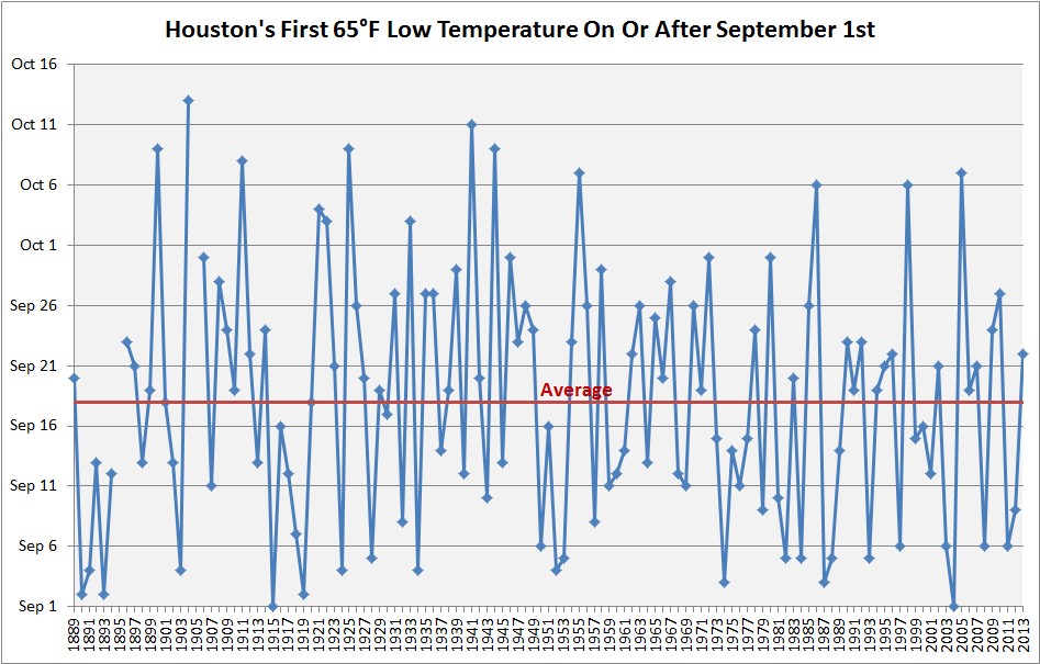
It’s time. If we define the “first fall cold front” as a nighttime temperature of 65 degrees or below at Bush Intercontinental Airport, then the average date of Houston’s first front is today, September 18. Alas, we’re not going to make it this year, but there are some hints in the models of a front pushing through before the end of this month (more on that below). That would be a good thing, because based upon Houston’s weather history, we only get into October without a “first front” about once every 10 years. And no one wants that to happen, do they?
Tuesday
Expect a mostly sunny day today, with high temperatures in the low- to mid-90s. This is kind of a classic summer day, and as there won’t be that many more of these this year, be sure and enjoy it if this is your thing.
Wednesday
A day like Tuesday, but with possibly a few afternoon showers and thunderstorms. Expect these to be fairly isolated, however.

Thursday
We’re going to see a changing pattern as we head toward the weekend, with the higher pressures that have limited showers in recent days moving off, and a corresponding rise in atmospheric moisture. I’m not sure if that will manifest in scattered or more widespread showers by Thursday, but just know that rain chances will probably be going up. As a result highs will probably be around the 90 degree range.
Friday and Saturday
Rain chances will be on the rise for the weekend, with a healthy 50 or 60 percent likelihood of precipitation for both Friday and Saturday. We’re not looking at a total washout, but I’d expect most of the area to get a healthy 0.5 to 1.5 inches of rain. This, and clouds, should help keep daytime highs in the mid- to upper-80s.
Next week and cold front?
A bit warmer, and a maybe a bit drier to start next week. By then we’ll all be desperately searching for that first fall cold front. So when is it coming? For really the first time, both the GFS and European models are pegging the arrival of a cold front perhaps 10 to 12 days from now.
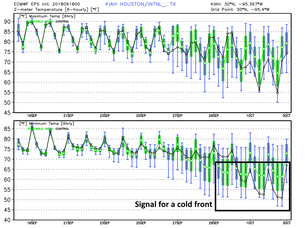
That consistency is a good thing. What is not so good is that 10 days lies near the limit of predictability for the global models, so we can’t exactly have high confidence in such a forecast. Still, historically, the region usually gets a first front by or before October 1, so a forecast for a first front about 10 days from now is reasonable. Fingers crossed, y’all.
When I see the first cold front in Texas I hear the “price is right” them song.
Here it comes…..
Buh Buh Buh-Dah!
Bring it (cold front) on!
Come on down!
Getting Fall going in Houston is kinda of like trying to start an old lawnmower. It takes a few tries.
Extended forecast starting next Saturday 29th shows highs in the low 80s and lows in the upper 60s and keeps it that way for several days, and I am very excited! I can already feel the drier air and nice gentle breeze on my skin, I might even use my sun roof for once. I sure hope this pans out.
My birthday is on the 27th. If you could cook up that cool front then, it would be the best present you could give a guy!
10-12 days you say? That would be PERFECT for opening weekend of Ren Fest.
I’m heading to an outdoor event in Austin on Saturday late afternoon and the reports say it expects to rain.
I know this is a site about Houston weather but I literally cant trust anyone else but you guys.
What do you guys see on the weather in Austin for Saturday?
Rain chances are as good in Austin, or even better than in Houston, on Saturday. Sorry.
Keeping my fingers crossed for it to blow through before Friday evening. Got an indoor/outdoor party planned!
I would be happy for a “Dry Front” aka maybe not all that cool but Dryer air, that in itself will make it feel cooler. But yeah, having the real thing is much better and ready for it.