Good morning. The overall forecast remains on track for Houston, with a strong Arctic front moving into the region tonight and setting up several days of colder weather. I still don’t things will get too extreme for Houston—much of the city probably will not see a hard freeze—but this winter storm will nonetheless have widespread effects across the state. Matt covered a lot of these issues in a post on Tuesday night.
Also, I’m not sure exactly what it means when the groundhog sees not his shadow, but rather the shadow of death, but I guess we’re about to find out. This is because Milltown Mel, a weather-predicting groundhog in New Jersey, died on the day before Groundhog Day. So, yeah.
Wednesday
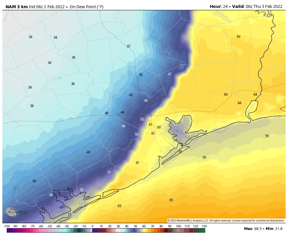
Fog is draped over much of the region this morning as air temperatures, generally in the mid-50s, have fallen to the dewpoint temperature. This fog will burn off as air temperatures rise today, and we’re probably going all the way into the low 70s even though skies will be mostly cloudy. Winds will be light, from the east, at 5 to 10 mph. Some scattered, light showers will be possible this morning, and into the afternoon hours, but I think the better rain chances will come over night along with the front. Said front will arrive in northwest parts of the region by around 8 to 10 pm on Wednesday night, should reach downtown around midnight, and push down to the coast around 2 to 4 am.
Thursday
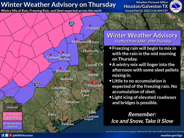
It will be a different world when you wake up Thursday morning, with air temperatures around 40 degrees, gusty northerly winds, and possibly some ongoing precipitation. The bottom line: It will be cold, windy, and possibly wet. High temperatures should hold at about 40 degrees during the daytime, and the possibility for some very light precipitation will linger throughout the daytime. What does this mean for our region? Well, it’s possible that areas northwest will see a mix of sleet and ice pellets during the daytime. A Winter Weather Advisory is in effect for Burleson, Brazos, Houston, Madison, Washington, and Grimes counties through 6 pm. Closer to Houston, we may see some sleet or freezing in the air, but surface temperatures should be warm enough to preclude any impacts on the ground. At this time we don’t anticipate significant impacts in the city and surrounding counties.
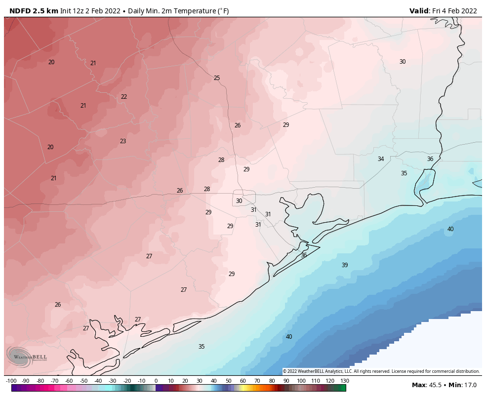
Another big question remains how cold it will get on Thursday night. It’s looking like clouds and winds of 15 to 20 mph should help keep the extreme cold at bay, with temperatures in the mid- to upper-20s in places like Montgomery County and west Harris County, and temperatures in the upper 20s to freezing in Houston and down to the coast. These temperatures should be warm enough to preclude bursting unexposed pipes.
Friday
This will be a cold, mostly cloudy day. Highs should peak in the upper 30s to 40 degrees, but a northerly wind will make it feel colder. But at least it will be above freezing. With more clouds on Friday night, lows should drop to about their same level as Thursday night, plus or minus a degree or two.
Saturday
Sunshine, finally. Clearing skies should help temperatures rise into the upper 40s to 50 degrees, and we’ll probably all welcome the lack of a stiff northerly wind. Lows Saturday night, under clear skies, should drop to around freezing in central Houston, with slightly cooler conditions for inland areas.
Sunday
The second half of the weekend looks quite nice, with highs in the mid-50s and ample sunshine. Most of the area should avoid a freeze on Sunday night.
Next week
Temperatures will be slow to warm as we head into next week, but highs should reach the low 60s by Wednesday or so, with lows in the 40s. Days should be partly to mostly sunny, with a mostly northerly flow. If you enjoy winter in Texas, be sure and get your fill.
My chihuahua did not see her shadow this morning. Too foggy. Guess winter is over for San Leon.
Milltown Mel has departed? Requiescat in pace.
Gents, I’m a huge fan! Thank you for putting all this together everyday. A bit of feedback on the app since you’ve been talking about it this week. In the Android version you can’t zoom in on the articles which makes the diagrams and images difficult to read.
Punxsutawney Phil is the definitive groundhog, not some New Jersey poser groundhog.
Glad to hear that this Arctic blast won’t put us in the dark but a stretch of cold weather could knock down the mosquito population as a side benefit.
And, being a little cold in February is par for the course. I’ll put on a jacket and brew up some hot tea.
Anyone else have to drive to work at 4:45 AM on Thursday morning? Should I be worried?…I’m guessing not based on your info, but I’ll watch for ice just in case. Driving through Memorial Park this morning I fully expected the monsters from Stephen King’s The Mist to appear. Imagining Lovecraft style creatures with this weather is all too easy.
Bless for y’all’s always helpful posts.
🤣🤣🤣
I rely on your take of our weather. You break it down so it is understandable. You explain the forces of nature which are at work. No frills, no politics, just good informative information . Know what else I like? The comments some of the folks make. Some are darn right humorous. I got hot tea, I got some good whiskey, plenty of firewood, plenty of warm sweaters and can binge on ‘Emily in Paris’ (SNL skit), if need be.
Looking to drive to Austin on Friday afternoon, should I be worried about the roads in the hill country?
Same here!
Should pipes be dripped in far west Houston on Thursday night?
Yes!!!
Time to make the Great Evacuation to Katy again! LOL
I’m ashamed to admit that such a post came to my mind.
Now that we have a winter advisory for inland Harris County beginning at 2:00 p.m. tomorrow, will you be issuing an update later today?
I think you need to issue an update soon. The forecast is comming in worse and colder. Now freezing rain and ice is forecast for Thursday night.
I’m thinking of fleeing back to norcal for the rest of the winter. Texas winters are just disgusting!!!
Winter is fine here. Try the Upper Midwest if you disagree.