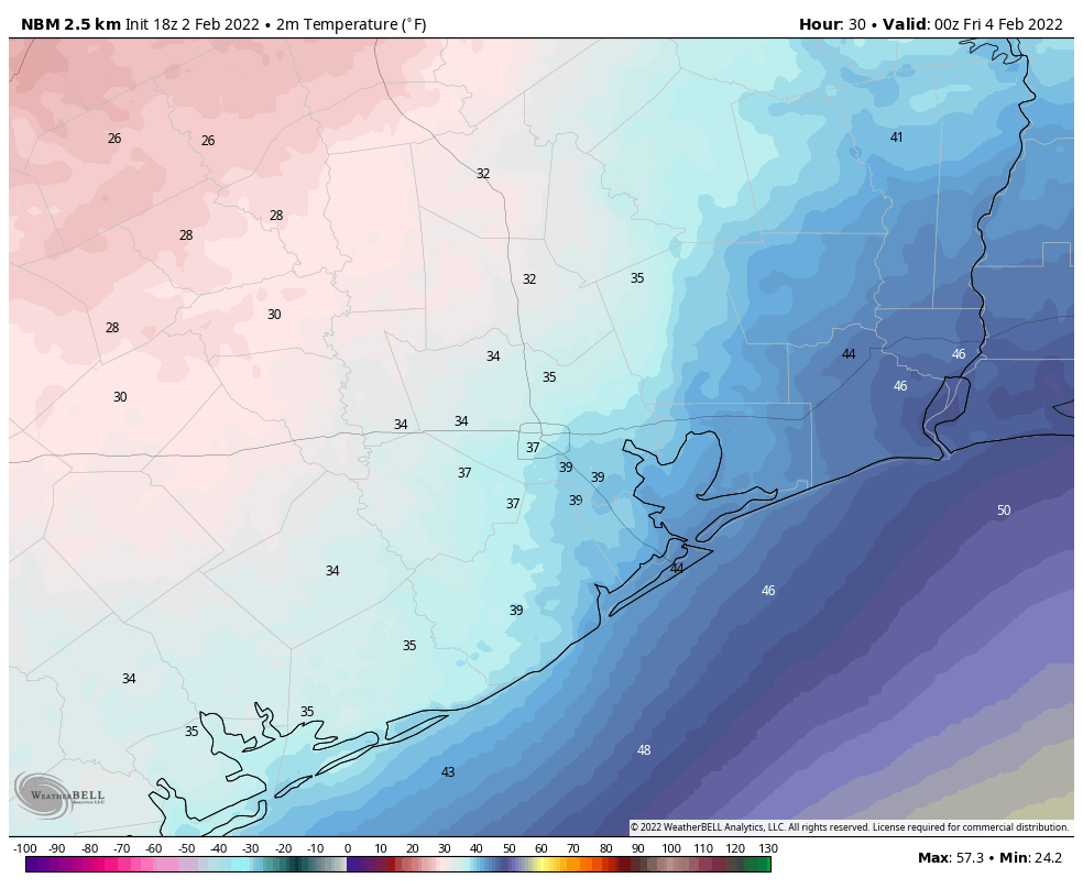
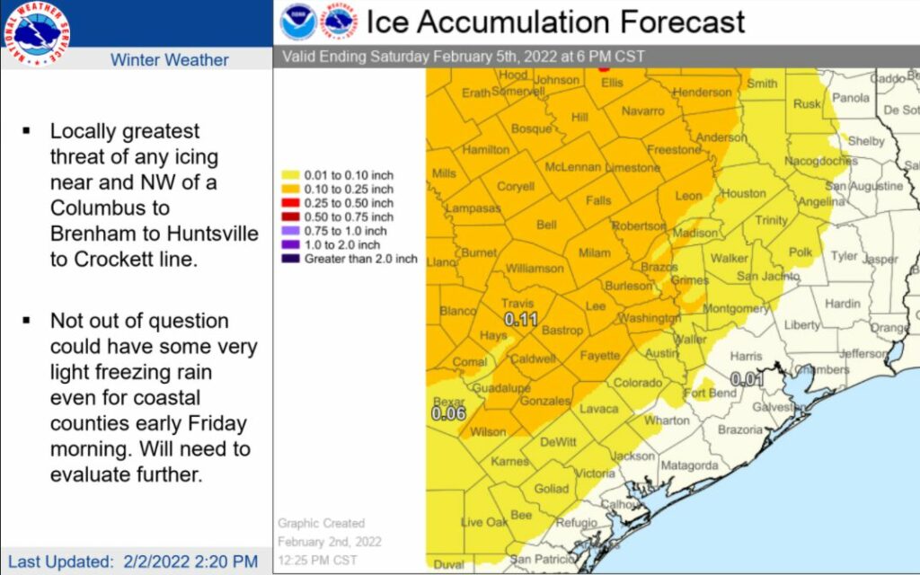
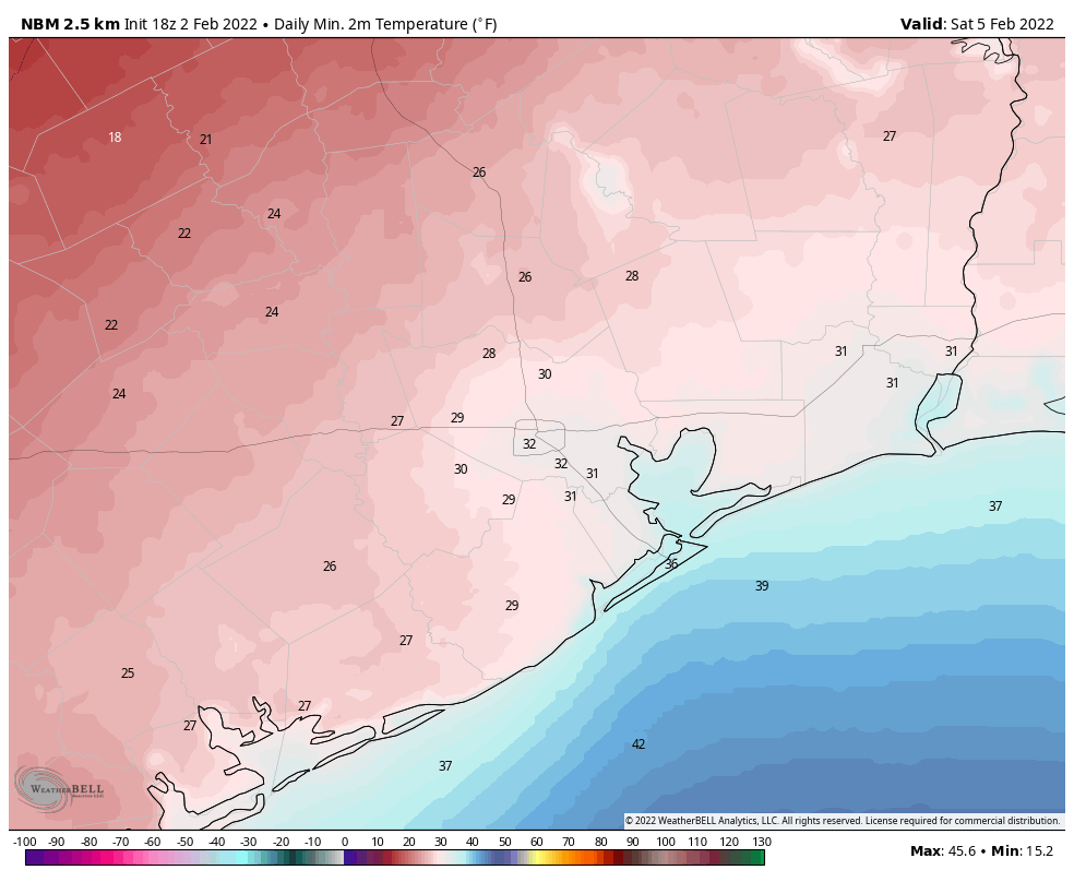
Good afternoon. As we get closer to the arrival of a robust cold front tonight, we’re getting better data about its impacts. It now seems possible that light precipitation on Thursday or Thursday evening could transition to freezing rain in parts of the metro area as temperatures fall to freezing. We still believe this will most likely have relatively minor impacts on the region, but cannot say that with full confidence right now.
The front will arrive in western and northwestern parts of the metro area this evening, including locations such as Katy and Tomball, between 9 and 11 pm. The front will reach downtown around midnight, and the coast around 2 to 4 am. The most noticeable changes with the front will be a wind shift and rapidly dropping temperatures. While intermittent, moderate rain showers will be possible after the front, the heaviest rains should end by Thursday morning-ish.

What we’ll be watching for on Thursday is the progression of a freezing line from northwest to southeast; from College Station through Houston, and potentially all the way to the coast. The latest modeling suggests this freezing line will reach College Station by mid- to late-morning on Thursday, and areas such as Katy and The Woodlands during the afternoon or early evening hours. At this point, while the heaviest rain showers will have ended, a light band of precipitation is expected to sag through our region Thursday evening and overnight. As this rain moves through it may transition to freezing rain on Thursday night all the way down to the Highway 59/Interstate 69 corridor, if not a little further.

What does all this mean? Travel in the College Station and Huntsville region could become hazardous later on Thursday morning, with some minor ice accumulations on roadways. In the metro area of Houston, travel during the daytime and early evening should be fine. But some slight ice accumulations are possible later Thursday evening and during the overnight hours. Because roads will still carry some latent heat, the biggest threat for any ice accumulations in Houston will be on elevated bridges and overpasses. Even this ice threat should dissipate as local temperatures rise above freezing by around 9 am on Friday morning.

It still looks like air temperatures will not fall all that far below freezing in the Houston area on Thursday night. Please understand that this is not going to come close to the deep freeze Houston experienced in February 2021, so please do not be overly concerned about that. There is also some reason to believe that the state’s power grid will be able to withstand this freeze, but obviously time will tell.
As this is a fairly dynamic event, things may change, and when they do we’ll report what we know, when we know it.
A message from Reliant
With the winter weather expected this week, Reliant wants to help make sure Texans are prepared. We’re glad to be a longtime supporter of Space City Weather and its mission to keep us informed in advance of weather events headed our way.
Below are tips that can make a big impact when temperatures dip below freezing:
- Charge your devices. Make sure your cell phone, medical equipment, tablets and laptop are fully charged ahead of time.
- Have a backup. Additional power sources can keep your home powered in case of an outage. Keep in mind winter weather can result in local outages caused by things like ice on wires or fallen tree limbs. These local outages are not related to the amount of available electricity generated and put on the grid. Texans should contact their transmission and distribution utility in the event they experience a localized outage.
- Download the Reliant Winter Prep checklist. Learn more ways to get your home and vehicle ready for dropping temperatures.
Reliant provides 24/7 support to customers via phone and online chat.
Thank you for the update!
You guys ROCK! So incredibly selfless in your efforts to keep the community aware of weather impacts in order to keep everyone safe! Sleep and pay be damned!!
The big unaddressed problem from Feb 2020 is the effect of freezing weather on natural gas lines which freezes water molecules in the natural gas. That was the Achille’s heel last year. (not green windpower failure as promoted by Abbott.)
Small comfort then from this statement by Ercot: “ERCOT has assessed the on-site fuel supply for some gas-fired generators.”
Hope Springs Eternal however. I did notice that at least one of those U-Shaped natural gas lines that stick out of the ground here and there –this one along Louetta Road in Spring — had been winterized.
I appreciate your low-hype weather analysis and maps. I often share them in my ‘San Leon and Bacliff Weather Page’ on Facebook.
The BEST weather crew out there. In retirement I play with weather models and you all use them RIGHT. THANK YOU.
Don’t forget to make sure animals are brought inside.
Do we need to be dripping out faucets at any point this weekend?
Those of us on the coast, Galveston County. Do we need to wrap pipes or let faucets drip??????.