Good morning. Houston remains on the edge of a high pressure system, so our weather this week will be slightly cooler than the last two weeks, with a puncher’s chance at some afternoon showers with daytime heating. The other factor to consider this week will be the influx of Saharan dust—dust kicked up over the large deserts in Africa and transported across the Atlantic Ocean by the atmospheric flow in the tropics. This dust will moderate temperatures slightly, but may also inhibit rain chances.
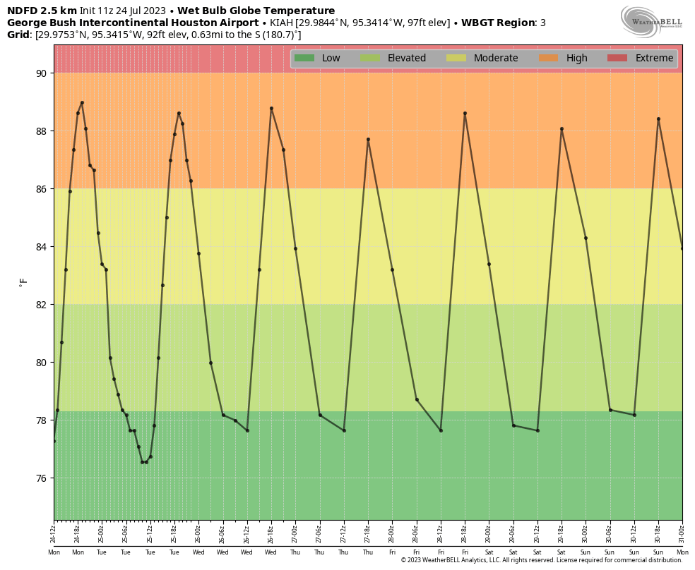
The net effect is that conditions will feel a bit more normal this week, and we can see this in the wet globe bulb temperatures we’ve been referencing. (These factor in temperature, clouds, winds, and humidity to provide a better overall sense of heat impacts). Previously this month we’ve see these temperatures reach extreme levels, but this week we should be more comfortably in the 80s. Which, don’t get me wrong, is hot. But not extremely so.
Monday
High temperatures today will likely top out in the mid- to upper-90s for most of the region, with mostly sunny skies. Showers and thunderstorms will be possible from early afternoon through early evening, primarily along the sea breeze. Rain chances today are probably in the neighborhood of 30 to 40 percent for areas south of Interstate 10, and 10 to 20 percent for areas for further inland. This pattern of better rain chance chances closer to the Gulf of Mexico is likely to persist for much of this week. Low temperatures will drop into the upper 70s tonight for much of the area, so slightly cooler than much of the rest of the month.
Tuesday through Friday
At this time there really is not much to differentiate the daily forecast for the remainder of this week. We are looking at daily highs, generally, in the upper 90s. Each day, primarily during the afternoon, we’re going to see a daily rain chance on the order of 20 to 30 percent close to the coast, with a lesser chances further inland. Winds will be light, from the south, and nights mostly clear.
The other factor this week is Saharan dust, which according to the latest modeling from NASA’s global modeling office should peak on Tuesday, Wednesday, and Thursday evenings. From time to time, Texas sees dust outbreaks from June through August. This layer of dust about 1 mile above the surface will bring dry air into the mid-levels of the atmosphere this week, and this may inhibit rain chances a bit. As this dust absorbs some sunlight, it should also help keep highs below 100 degrees. And finally, of course, it may lead to some rather vivid sunsets.
Saturday and Sunday
I have some questions about the pattern this weekend, as some modeling indicates a return to a very hot pattern in which high pressure prevails. However there is also a chance that our region stays just beyond this high pressure system. For now, I’m going to broad-brush things and say we’re looking at highs in the upper 90s with only a slight chance of rain.
Next week
Looking beyond the weekend, our weather next week probably will bring more of the same, in terms of mostly sunny skies and high temperatures in the upper 90s. At this point rain chances may turn slightly better later next week, but at that point my crystal ball starts to get pretty fuzzy.


Recent GFS runs have looked absolutely apocalyptic lately heat wise for the start of August. Is that just a symptom of the GFS’s issue with feedback going off the rails in longer-range forecasts? (I really don’t want to experience highs on the order of 106-109F…)
I remember 110° summers growing up in Galveston. Nobody stayed inside back then either. Not sure how we survived. Lol.
I cannot find any record, going back to the 1870s, that shows Galveston getting very close at all to 110. I think we tend to embellish, or overdo the heat or cold from where we grew up. That said, point is that it was hot and we did what we did as kids. I grew up in OK on-and-off so definitely remember summer days outside, but I won’t go as far as to say I knew just how hot it was.
No you don’t. The record temp sent in Galveston was 104 degrees, which happened in September 2000.
Likely a recollection from getting in the car and turning it on. Official temps are 2 meters off the ground, away from hot pavement, and in the shade.
I saw 111 on my truck thermometer the other day but that’s the temp inside a hot engine compartment, in the sun, over hot pavement. I remember similar or higher readings from previous years.
No you didn’t. Heat records have been broken since the new millennium. June 2023 was the hottest month EVER in the US and globally. Like it or not, this is the result of climate change. Check out the records that have been broken this Summer. Facts don’t lie.
Quite right. I can only assume it is politics that causes people to set their intellects to one side.
Pouring in Freeport this morning.
Nice! I shall imagine it. No rain in the loop since July 7. How about everyone else?
Driving around yesterday we could see rain in the distance. We thought we saw a rain drop on our car windshield……turned out to be just a speck of dust….:(
Nothing in Katy.
Heavy downpour at 288 and BW8 on Sunday around 5:30. When I got home a couple miles away, all I saw was 0.07″ Rainfall. It was a nice light show as well.
We had a Texas 8″ of rain Saturday night. Rain drops were 8″ apart!
Seriously, 1/10th with a little thunder Saturday night.
Yesterday was the first time we actually had a downpour in Sweeny since June 5th. Unfortunately it was just half an inch. We need much more. There are still 2 inch wide cracks all over the yard. The grass has turned yellow and brown in most spots.
Lucky!!
Appreciating web bulb global temp info. Really tells me how it will feel. Better than just “feels like.”
I was wondering if the Saharan dust was back. It is a regular summer visitor, and I had noticed that the skies looked hazy the last few days, and also that the sunset last night was very red and pink, which the dust usually causes colorful sunsets.
The only positive is August is only a week away and that means only 5-7 more lawn mowing sessions that feel like they are going to kill us.
Pour in Port Arthur Saturday. Had a great lightning show accompanied by house shaking thunder and heavy heavy rain. I forgot how beautiful storms can be.
I saw an article yesterday that said that this July the earth has had its hottest day in recorded history.
Good news we actually had a shower develop which just dumped an additional 3/4″. So we have had 1.25 inches between today and yesterday.
Nooooo stop. Hey jealousy…. I’m seeing nothing. And there’s no “sea breeze” by downtown. Just dry breath
I like that this forecast is trying to be hopeful and half-full and lemonade-y. Still, at 4pm, weather.gov has 102 for my part of harris county. Well, we will try again tomorrow. Sigh.