A combination of slightly cooler temperatures and slightly lower dewpoints means that the National Weather Service, for the first time in more than two weeks, has not issued a heat advisory or an excessive heat warning for today. These moderately cooler temperatures—mostly highs in the mid-90s instead of upper 90s to 100 degrees—will continue for the rest of the work week before nature’s thermostat rises again.
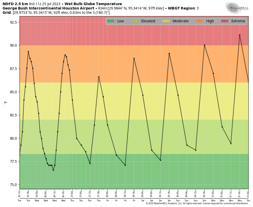
We can see this slight moderation in wet bulb globe temperatures, which we have been referencing during this summer’s heat wave. They will remain at high, but not extreme levels, until this weekend. One reason for the slight diminution in temperatures is the presence of Saharan dust in the atmosphere, roughly 1 to 3 miles above the surface. This reflects a bit of sunlight, decreasing the amount of energy reaching the ground. Unfortunately this increase in drier air may also wipe out chances for meaningful rainfall, which is badly needed.
Tuesday
Highs today will reach into the mid-90s for most of the region, with mostly sunny skies this afternoon. As we have experienced for a couple of days, rain chances will increase during the afternoon hours, particularly closer to the coast and along the sea breeze. However, I think chances will only be about 30 percent south of Interstate 10, and lesser for inland areas, partly due to the Saharan dust (levels of drier air make it more difficult for rain to reach the ground). Overnight lows may briefly drop into the upper 70s. Winds will be light, out of the south.
Wednesday, Thursday, and Friday
More typical, late-July-like conditions will continue through the end of the week, with highs in the mid-90s, and slight chances of rain along the afternoon sea breeze. If you’re looking for the “coolest” day in a while, that may be Thursday, when highs may not reach the mid-90s in parts of Houston, even away from the coast.
Saturday and Sunday
The weekend should bring us back into highs in the upper 90s, with coastal shower chances in the vicinity of 20 percent. So hot and sunny, for the most part.
Next week
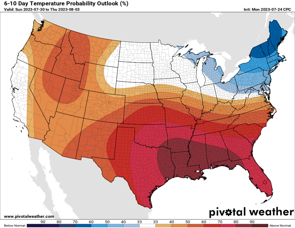
This weekend and the early part of next week, truth be told, look pretty hot. I expect we may see another 100-degree day, or two. However, if I squint into the future I can see perhaps a return to slightly more moderate conditions by the middle of next week, with perhaps some healthier rain chances. That is part hope, and part science, however, as we’re talking about a forecast 7 to 10 days from now. As noted in the headline, don’t break out that sweater just yet.


If anything good can come out of the last 16 days is these next few days look to feel relatively cool. That wet bulb forecast for Thursday looks fantastic!
Thank you! I am very grateful for the WBGT that you have been reporting. An important indicator and consideration for anyone working outdoors or engaged in vigorous outdoor exercise.
Thank you for providing Unbiased information. Those who get upset with you using certain terms need to take a chill pill. EVERYTHING is cyclical. Either warmer or cooler. My Family has lived in Conroe since 1985 and I have a handwritten log back to from then to 2013 when my father passed.
During some of that I lived in Phoenix for 18 years so I have a perspective from there too during that time and Pepperidge Farm Remembers LOL when it hit 127 and routinely hit the high one teens to low 120’s for days on end. Looking back at my personal history I just SMH at people not having some perspective!
No matter how many capital letters you use, this is not cyclical weather, the heat is not going to come down if we don’t pay attention.
Yes, Phoenix it has nothing to do with the massive increase in paved acreage that acts like a heat trap Plus all of those 100s or 1,000s of pools dumping moisture into the air in the valley surrounded by mountains has absolutely nothing to do with it.
SCW has mentioned that Houston is also having some of the same effects that the heat island of the urban sprawl expands. Driving from Conroe into the woodlands I normally see a minimum of a 5 degree increase and by the time hit the 610 it’s 10 degrees. Some of that is progression of the day but the rest of it is the heat island effect that any major metro area is experiencing
The real Paul Atreides knew that people are capable of altering the climate.
The great news about scientific data capture is that it keeps us from having to rely on personal anecdotes to describe historical events and establish patterns. It’s great you have a handwritten log but it’s also telling that you reference 127 degrees in Phoenix when the highest recorded temperature on record is 122 (26 Jun 1990). You also mention “120’s for days on end” which would be inaccurate given that Phoenix has only hit the 120’s 3 times in the past 100+ years.
I get it. Weather is something we feel so we tend to harken back to our perceived experiences, but they are no substitute for looking at the numbers and the science behind those numbers.
You are correct. One thing that is tricky is in some instances when there is an agenda to be promoted for anything in life the data gets reframed to fit the narrative. Back in 1990 when Phoenix hit their high the official temp at the airport was 122. The reports from all over the metro area were from that as a low to the 127. I remember they had to curtail flights because out on the runways the Density altitude charts wouldn’t work and the aircraft were experiencing higher temps on the Tarmac
That’s why I like SCW as it is very factual. Once and a wile they may use the latest phraseology and I just take it with a grain of salt.
In some cases, not with the SCW blog, organizations are switching from air temperature measured from a given point of elevation for many years to using surface temperature. To me that’s like saying Oh the Temp today is that of the dashboard of my car vs the actual temperature at a fixed point for numerous years.
Our lifespans are too short to have a meaningful recollection and without consistent data and before there were people in a given place it is only subjective to your particular location and experiences. The way I look at it is that in 5 billion years we’re gonna fry anyway. In the meantime we do what we do best and that is adapt.
Just regular today?! Happy Birthday to me! (it is legit my birthday)
*regular heat
I keep telling myself that one day (not really soon) I will be stopping on the page to read about the first cold front. We will get there!
only like 3 1/2 to 4 more months of miserable heat to go!
I guess dragging hoses yesterday wasn’t too much of a waste. Please just a moderate amount of rain.
You know my extended family has pictures going back decades. Pictures of freezes, thermometers etc. Lot of the folks in my area who have been here for generations have the same thing. I can truthfully say that the official records don’t always reflect records of locals. Not sure what it means. Not even sure why I mention it. Everyone was hunting, fishing and growing their own produce so they were very aware and tracked these things. Seems to be mostly prior to 1980 according to previous generations that the records don’t jibe. I am in Galveston County.
Hey! My county is only in the yikes! red heat blob as opposed to the yowza! dark red blob of pain next week. Probably still awful but I will take what I can get.
The rain gods were pleased with us at 3:30 this afternoon near Westchase, dropping 1/2″ of lovey nectar.