Today, we’ll walk you through the forecast once more. Toward the end, I have tried to ask and answer the most common questions folks would have about the upcoming rain event this weekend. I think you’ll find most of your answers there.
Today through Friday
No changes to the forecast the next few days. Expect more partly to mostly sunny conditions. High temperatures will peak in the low- to mid-90s. Yes, a few showers or a thunderstorm will be possible on each day, but consider yourself lucky if you receive one. Most of us should remain dry.
Saturday
One of the changes today is that Saturday now looks like our transition day instead of Friday. Precipitable water values, which measure the availability of moisture in the atmosphere, go from about 1.5 inches on Friday to 1.9 inches on Saturday. What does this mean in layman’s terms? It means rain chances should go up a notch. As of right now, Saturday’s rain and storm coverage shouldn’t be terribly significant, but it will be more than we’ve seen lately. Locally heavy downpours could occur Saturday as well. With more clouds and rain, temperatures will ease back a bit, and we may not even hit 90 degrees for a change on Saturday.

Sunday and beyond: Tropics
So, we’re one day closer with this tropical disturbance, so we should have this all figured out now, right? Yeah– not entirely. So for those that have been following along, here’s what’s new this morning:
- Chance for development remain very, very low. The National Hurricane Center continues to hold only a 20% chance over the next 5 days.
- The rainfall forecast has held steady or increased just a little bit.
- Timing for the heaviest rain has narrowed to maybe Saturday afternoon through Tuesday, but primarily Sunday and Monday, before much of the rain likely shifts into interior Texas.
Let’s analyze what we’ve got going on here this morning. Satellite shows a very poorly disorganized disturbance off the coast of Central America. Thunderstorm activity has looked more impressive the previous two mornings than today.
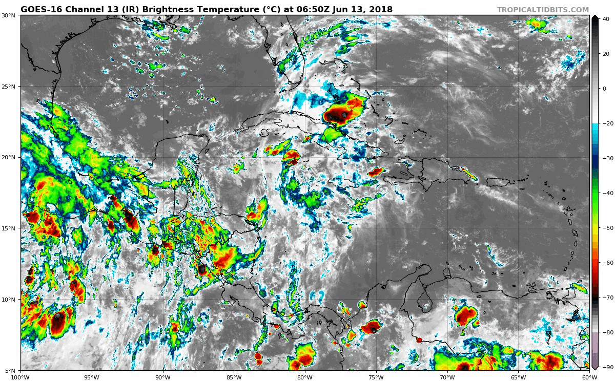
The National Hurricane Center still shows very low risk of development over the next five days (20%). At this point, while I’m not ready to say there’s zero chance this thing will organize, the final impacts to our area will not be very dependent on whether or not it gets assigned a technical label. So I’m no longer worried about whatever it will be called when it gets here. The impacts are likely to be the same.
So with that in mind, let’s talk impacts.
Wind? Not a big issue. It’ll be breezy at the coast over the weekend and into next week, with 15-25 mph winds, perhaps up to 30-35 mph at times. With any thunderstorms, we could see some stronger gusts, but widespread strong winds won’t be an issue in Texas.
Coastal flooding? Minor run-up and higher than usual tides should be expected along the Gulf coastline but this will be primarily nuisance stuff. Still, if your weekend plans take you to Bolivar or elsewhere on the Texas or Louisiana coasts, just be advised you may run into some minor inconveniences.
Rough seas and rip currents? Yes. It will be choppy on the water from Friday or Saturday into early next week. Rip currents are likely to be quite strong, so if the weather cooperates for swimming this weekend, use extreme caution.
Sunday and beyond: Rainfall Q&A
Let’s tackle this rainfall issue. No one in the Houston area wants to talk about heavy rain, but it’s Houston so it’s going to happen eventually. I’m going to do a Q&A here to try and answer most questions. Consider this basically a user’s guide to the weekend rainfall.
How much rain do we expect? We still need to be general with this. I think a safe starting point remains a widespread 2-4″, with smaller pockets of higher amounts, perhaps as much as 5-9″ over the period between Saturday and Tuesday.
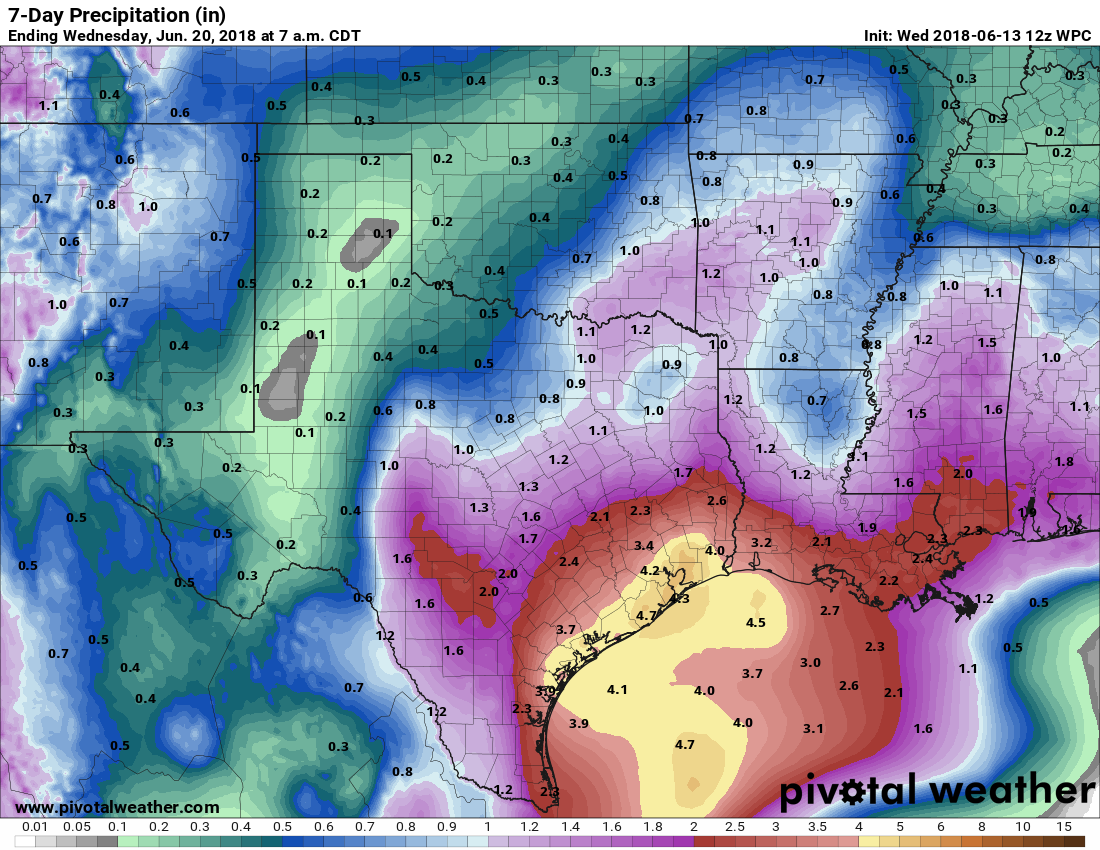
Above is the official NWS rainfall forecast right now for the next seven days. It shows a widespread 2-5″ in our area.
So why do I say “isolated pockets of five to nine inches?” Rain events like this are exceptionally difficult to forecast. Weather modeling cannot resolve where more persistent rains will setup or linger until we get within 24-48 hours of an event. They may show a “blob” of heavier rain forecast for Monday in Louisiana on today’s runs that verifies as a narrow axis of heavier rain in Texas. That’s just the nature of weather modeling. Doing that math, we’re not going to have a good handle on anything specific here until at least Friday. But it is implied from the modeling and experience with rain events here that we could see that much rain in localized areas. We just can’t tell you where at this point.
Who will see the most rain? Again, it’s too early to say. Initial indications from modeling has been pointing to the immediate coast seeing the heaviest rains. So Freeport to Galveston to Port Arthur. I do think some of the models are underdoing how far inland the rain can penetrate, so I think we’ll see everyone get into heavy rains at some point or another. But I think it’s safe to say that the greatest likelihood of the heaviest rain at this point will initially be south and east of US-59.
What about timing? The best chance for on and off heavier rain begins on Saturday night and lingers until Monday night. There will be higher than usual rain chances both on Saturday and Tuesday, but the focus, to me, looks to be Sunday and Monday. Rain should then spread south toward Corpus and the Rio Grande Valley and west into interior parts of Texas.
So, perhaps as much as 5-9 inches? Will there be flooding? Again, we simply can’t say. I fully appreciate that this isn’t the answer anyone wants, but we can only work within the boundaries of what science allows. And it’s too soon to tell you with any specificity. I will say, that, given the signals on the models, I do think we will see isolated (not widespread) areas of flash flooding by Monday or Tuesday. Remember, most areas are probably going to see less than that amount of rain.
But I thought we were heading into a drought? Yes, it has been dry lately.
The ground can absorb a healthy amount of rainfall initially. Bayous and creeks are low. Over a period of one to six hours, we can absorb anywhere between four and six inches of rain before flash flooding would commence in most cases. But, if we do see repeated rounds of storms Saturday, Sunday, and Monday, we may start to see the ground become saturated and flash flooding will become more of an issue in some spots.
So if it’s not a tropical storm or hurricane, why are we going to see such a heavy rain risk? While the system itself probably won’t develop in any meaningful capacity, the moisture coming with it is abundant. In fact, weather modeling is forecasting near record June precipitable water values for Monday in the area. In other words, about as much moisture as the atmosphere can hold this time of year. This means that as long as we can get thunderstorms going, which shouldn’t be too difficult, we’ll likely see some very heavy rainfall in spots. It should keep moving and not stay stuck in one place for too terribly long at any one time, but again, repeated rounds of storms will add up and probably eventually lead to some flash flooding somewhere in the area.
Does Hurricane Bud in the Pacific have anything to do with this? We haven’t talked much about Bud, but it’s possible that some of the dynamics associated with the storm could help to indirectly enhance rainfall over East Texas. This isn’t a scenario I’m particularly hung up on though, and while it could enhance rain in some capacity, it will be a significant rain event for us without that involved. Rainfall directly associated with Bud itself will move into the Southwest and Rockies.
I remember Harvey forecasts started relatively small and then just kept going up, up, up. Could that happen again with this? I know people here are on edge (we live here too, so we know the feeling ourselves!), but this is not Harvey. We get heavy rainfall events here in Houston more often than we’d like, but that’s what we have to accept. Events like the one we’ll likely see here Sunday through Tuesday, I would spitball, happen once every year or two. Could we see rainfall forecasts escalate a bit from here? Absolutely. But Harvey had an almost limitless ceiling it seemed. This appears to have a ceiling. Weather models aren’t getting progressively worse as they run like they did in Harvey; they’re really just moving the axis of heaviest rains around.
We’re giving you our honest best guess on rainfall above. It would be irresponsible of us to do otherwise. We believe in no-hype, but we also believe in honesty, so if this looked like a 20-30″ rain event, we’d tell you. And right now, this is not even remotely that. But, that said, you have to realize that our standards may have changed post-Harvey. Five to nine inches of rain is still a lot of rain and can cause some problems if you’re in one of the areas seeing that much rain. But in most cases they’re more nuisance and inconvenience than anything and any serious problems would be localized, not widespread. Still, we’ll continue watching and let you know if things change.
Eric will take over the helm tomorrow and have the latest. I’ll try and answer what I can when I get a few free moments on Facebook, Twitter, or in the comments.
Thanks Matt. Great job. You covered everything.
Keep up the great work guys!
I’m flying back home from Europe Saturday, supposed to land around 6PM. What is the likelihood we are going to be delayed or diverted? I really want to get home 🙂
I can’t make promises obviously, but I think you’ll get in.
Thanks Matt, yall are the best and I appreciate your honestly! It looked like the forecast was trending in the positive for me so I’m hoping it continues on that path.
Would you reschedule a noon flight to Cabo on Sunday? Hopefully Bud won’t be an issue anymore.
Personally? I probably wouldn’t. But that’s a tough call. I would anticipate some possible delays though.
I think Harvey has given the Houston area the Katrina/Rita effect. Harvey was a generational storm. Extremely rare to have something like it to hit an area frequently. We need to power down in our thoughts about tropical disturbances a little bit. I’m not advocating to not be informed or “keep an eye to the sky” but local news outlets seems to get people in the hypnotic hype panic with the marathons of endless looping. Thanks again Matt and Eric. I’ve turned quite a few of my friends on to the website with no hype.
Harvey was, simply, unprecedented in US history. And, for better or worse, it reset what constitutes heavy rain. Since then, I’ve seen places forecast to receive 5, 6, 7 inches of rain over the course of a week, and only slightly jokingly referred to it on Twitter as not even being a good overnight shower here. I’ve also discussed with Matt and other Houston weather tweeps about the very real heavy rain PTSD here. I am hoping to see that discussed at some point, if not in Harvey’s service assessment, then in something else.
The “PTSD” comment is a good point. People who were flooded out will not deal well emotionally if we get prolonged heavy rain for a day or two. Heck, at our house all we had was rainwater seeping in from the back yard–more of a hassle than anything else–yet these days the sound of heavy rain on the roof makes me anxious.
Consider a backup generator.
I cried the first time it rained after Harvey. The PTSD is real.
I somewhat agree
Was there any damage from last nights storms???
I cant seem to find any reporting on that
Do you have any idea about what time the rains will roll in? My daughter’s birthday party is on Saturday from 11-1. It’s a pool party, so I need to know if I should come up with a plan B.
Thanks for all you guys do to keep Houston informed!
I would have a backup plan in mind, just to be safe, but I think you might be able to get it in. Fingers crossed!
Interior question here. We have a cabin on the Sabinal River in Utopia starting Monday. Is our week, literally, going to be a wash?? 🤷♀️
Entire week? No. But Mon-Tue and perhaps Wed would see decent rain chances there. Not raining the whole time I don’t think though.
Thanks, Matt. We are there Monday through Thursday nights. Hopefully we won’t get cabin fever!
Thank you Matt for the details! My dear Fulgenio and I are prepared for the floods but hopefully we won’t be in the 8-9 inch range as that causes us issues. Bless all and enjoy the rains.
This is refreshing! I was worried about Fulgenio during the heavy rain in late May! Please keep us posted if we have a weather event on how you two are doing please!
I wish I had someone that care about me as you do Fulgenio!!!
(We’re having some minor issues with SCW’s caching, which is affecting the comment system—it might take several minutes for a submitted comment to show up. I want to wait until the morning rush dies down before I start monkeying with the server to fix, so please be patient and don’t submit the same comment more than once. I promise it will show up—it just might take 10-15 minutes.)
Thanks, Lee!
I know your level of detail is probably unnecessary for a storm of this size, but THANK YOU. We need this and I’m so grateful.
Have they lowered Lake Houston levels in anticipation of the heavy rain?
Any thoughts on impact over Lake Charles area for Sunday?
Great report. Thanks!
I noticed that there was a “rain event” a year ago yesterday that was “tropical” in nature. Seems that we have some sort of a pattern here.
Thank you so much for that detailed report!
How bad will it be in the Heights on Saturday night…specifically around Yale and 19th street at 6:45? Big family dinner plans depend on this forecast.
Thanks for your continued no hype reporting on the weather! I am heading to Dallas on Monday morning. Debating driving vs. flying due to weather – based on your recommendations here, I will likely take the bus or drive to avoid weather delays.
Hello,
I have a family member considering driving in to League City from Ft Hood this weekend for Father’s Day. Do you think that would be a safe drive to make? It would be one adult and two toddlers.
Thanks,
Travis
Heading to Lake Charles for the weekend. Is it going to be a total washout? Thoughts as far as the safety of driving back on Sunday?
We’ve got an early morning flight out of Hobby on Monday morning, like 5:30am. We’ve got to drive up from Galveston.
How crappy is that drive going to be? As in, dangerous? Should we figure out a way to stay closer to the airport?
As always, thanks guys for being straight shooters.
Going camping Sunday – Thursday down at Jamaica Beach RV Park. Wondering if I should delay arrival to Monday??
Matt, thanks as always, after Harvey I have checked your posts regularly. I live in the Cypress Creek area (little Cypress Creek is literally in my backyard), and much like the comments above I probably do have rain PTSD to some degree. Would it be premature to start flood prepping? The creek is at its absolute low, however given past experiences it fills up fast. Thanks as always.
Matt: No, I don’t at all think you need to go that far. Just keep tabs on the forecast, but I don’t think you’ll be getting to that point, personally.
Also Harvey PTSD here. Any idea if the dams (specifically Barker) will be closed ahead of the storm?
I don’t know if they will be closed, but I know they are empty (and they should be able to handle the rains as currently forecast). I know it’s easier said than done given recent experiences, but at this point, we don’t see much of anything to worry over. Just stay aware and informed.
The NWS map has shifted the yellow blob to the south, heading more directly into Mexico. What is the significance of that change?
Good afternoon. I have flight out of Houston early on Tuesday morning. Do you foresee any conditions that could affect departure? I know it’s a little too far out to know for sure.
My daughter is flying out from IAH Sunday at 6pm.
Must return to WA state Sunday night.
Should she try to get and earlier noon flight out.
Thanks
In response to the lion, I think historically that June has had some ballywonkered rain events. Matt, were either Alvin’s – previously the record – 41” of rain and/or the only Astrodome rain out in June also? I remember both vividly, being in teens at the time.
For the Astrodome rain out, we were coming home from yet another family vacation to Galveston – oy, that’s all my pops wanted to do in those days – and the rain on 45 south just kept getting worse and worse. Car stalled out due to high water, but at least we made it home. And for the few folks who were already at dome when game was called? A quickly arranged table set dinner on the field!
The then-record rainfall in Alvin was in July 1979, curtesy of TS Claudette.
Can you tell me precisely (to +/- .001″) how much rain will fall on the NE 1/16th corner of my lot between the hours of 12:55 PM Saturday and 01:30:45 AM on Sunday morning? Or should I delay applying bug spray until later?
And Blackhawks Fan for the win! Now to address that potential looter situation….
I’m considering moving to Katy so I can evacuate.
You forgot to ask about the driving rain trajectory and the expected psi. You’ll want to make sure your rainwear will be up to the task while you apply that bug spray.
Thank you, truly, for all your efforts and no-hype reporting here. I’m sure I’m not the only one who’s now a nervous wreck every time it looks like it’s going to rain, and it’s so incredibly helpful to have a reliable & realistic source to turn to. Thank you for taking all the time to explain everything so well. Y’all were my anchor through Harvey and I just really appreciate you.
Port Aransas this weekend…total washout or some pockets of beach and pool time?
Such a great/detailed report. Thanks for taking the time to give your Houston homies the facts!
Tks Matt. Very well written and understood. Tks for taking the time and patience in writing for us ‘oldies but goodies’.
The best in the business…. Thanks Matt
The best in the business… Thank you
When you say 2-5”, What does that truly mean? Is that a total through the entire rain event, an hourly estimate, per day? I see this and I want to understand. Thanks guys.
Thanks for your informative post! We are going to Galveston this weekend…so we will make the best of what is to come!