A lot going on in weather, so let’s hop to it.
Today through Thursday
Pretty status quo weather the next few days. Expect partly to, at times, mostly sunny skies, with highs in the low- to mid-90s. Rain chances will tick up each day just a little bit. Expect maybe just one or two showers today, then perhaps three or four showers tomorrow. You get the idea. Thursday will be the best rain chances of the next three days, but even that should only result in isolated to scattered thunderstorms in the afternoon as it stands right now.
Friday
Friday appears to be our transition day from the pattern we’ve had most of summer so far to the higher moisture and rain chance pattern, influenced heavily by what happens in the Gulf. Expect highs in the upper 80s to around 90 degrees with a smattering of afternoon thunderstorms in spots, though still very hit or miss.

Weekend and Beyond
Here’s what you need to know about the tropical wave/rain chances from the weekend into next week:
- Organized tropical development, while possible, is unlikely in any significant capacity.
- The story of this disturbance for our area and what you should be focused on will be rainfall, with several rounds of locally heavy rain possible from Saturday through Tuesday.
- We will likely need to watch for localized flash flooding issues beginning Sunday or Monday.
- Even if this system doesn’t become a technical tropical depression or storm, rough surf and strong rip currents, as well as some minor tidal flooding/overwash issues will be possible along the coast; this weekend at the beach may be less than ideal.
Yesterday we discussed a bit about why it’s not one model versus another and why what we’re seeing in the models, trend-wise, isn’t terribly surprising. That’s held up since yesterday. Now we can start focusing more on impacts. It’s still very early though. And I must warn you: In these types of scenarios, trying to forecast specifics in terms of coverage, locations, and amounts of rain is difficult to impossible more than 12-24 hours in advance. We can make a good deal of broad assumptions though today.
The National Hurricane Center has outlined our disturbance this morning with a 20 percent chance of some development late this week when it enters the southwest Gulf of Mexico.
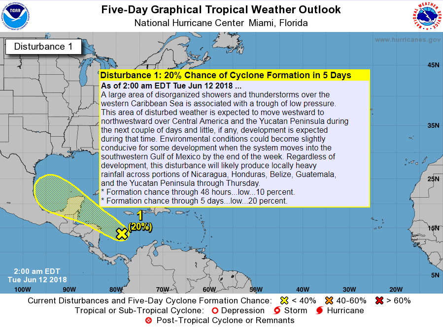
While we will keep an eye on any development risks in the coming days, we remain mostly unconcerned about anything substantial wind-wise.
Frankly, weather modeling is now in pretty good agreement on the overarching situation for this weekend: A tropical disturbance approaches the South Texas coast, and flings substantial amounts of atmospheric moisture at both the Texas and Mexico coasts, increasing daily rain chances this weekend and early next week.
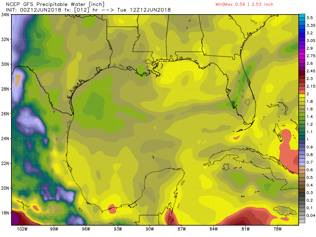
The animation above shows precipitable water, or a basic measurement of how much moisture is available in the atmosphere. The higher the value, the better chance for heavy rain. You can see the red and purple colors on that animation approach Texas on Saturday and linger to some degree through Tuesday.
So what does that mean? It means if you have outdoor plans for Father’s Day weekend, you may want to start prepping a backup plan. It also means that we are likely going to see multiple days with scattered thunderstorms. In any normal scenario, this means at some point, we might have to watch for flash flooding potential.
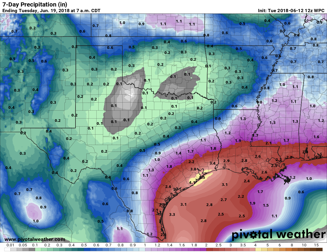
The current rainfall forecast from the NWS shows a pretty widespread 2-4″ of rain, roughly along and south of US-59 in Southeast Texas. It can be assumed from this that locally higher amounts will be possible. And this forecast will likely continue to change and evolve in the days ahead.
So, to be clear, yes, we will need to monitor things this weekend and especially early next week for potential flash flooding. We live in a place where heavy rainfall happens fairly frequently. We’ve been pretty fortunate since Harvey to not have to deal with too many instances of it. And we may get through this setup fine too. But, when I start to see these rain totals, I perk up a little. To be clear: This isn’t even remotely like a Harvey, Allison, or Tax Day type setup. But this is a setup that would favor pockets of excessive rainfall, potentially leading to a localized flash flooding risk in parts of the area. We can’t tell you where. We can’t tell you when, besides saying that the best odds would be from Monday onward, assuming we should be able to handle the initial rains without much trouble due to recent dryness. But we can tell you the setup does look favorable for potentially having to deal with some of that heading into early next week.
Again, we may be just fine, see some rain, and the heavier rain risks may trend more toward Corpus Christi, interior Texas, or Mexico. But, as of this morning, this is where we’re at, and model agreement on the big picture is pretty good right now.
So, to summarize once more:
- Very, very low risk of tropical development and likely that whatever were to develop would stay low-end from a wind perspective.
- What you should be focused on: Increasing risk of a multi-day on again/off again rainfall event.
- Rain totals in excess of 2-4″ over the 4 days between Saturday and Tuesday are becoming more likely.
- No one can tell you exactly who will see the most rain, when the most rain will fall, and exactly how much that will be; those details won’t be able to be ironed out until late this week and during the event.
- Yes, pockets of flash flooding will be possible. We’ll get a better read on that by Thursday or Friday.
More on Wednesday morning.
Thanks for the forecast. I followed you guys over Harvey and you were always spot on. We will continue to listen, watch and prepare. Bob, radioKair
Flash flooding, does that mean street flooding, or are we talking intrusion into people’s homes again???? Just want to be clear on terminology…
Good question and tough to answer with any certainty. You just never know around here. Probably mostly street flooding. But I don’t want to make any promises I can’t keep. We just have to wait and see. Again, this doesn’t look even remotely anything like an Allison or Harvey or Tax Day, so just so you know it’s not a super-high ceiling rain event.
What are your qualifications for declaring such an event?
Looting? That escalated quickly.
Clearly he’s joking. Bring on the scare-icane.
It’s good to see someone promote weather facts opposed to weather hype..it’s a water event so please don’t go to your grocer and wipe out the water supply.(You all know what I’m saying)
We need whatever rain we get. Hooray!!
Thanks for the un-hyped info about what is likely to happen this weekend. Your site is my “go to” site for honest and accurate as can be weather forecasting. I greatly appreciate it.
I enjoyed the “weeds” explanation of both the GFS and Euro models.
From your comments it seems like the “sweet spot” for forecasting these types of events lies in blending both the GFS and Euro models so that their biases may cancel each other out.
Is it possible to tweak each model to reduce the known biases or does that introduce additional errors?
A blend of the two models is helpful, but not always ideal. They do try and improve the models by fixing biases, but as you’d expect when you’re trying to model the whole atmosphere, it can get a little tricky. And sometimes, fixing one problem can lead to unintended consequences of creating new ones. So the best answer is that they try…but it doesn’t always work. Hope this is helpful!
Thank you Eric for clear headed forcasting. I was very upset Friday when I saw a local weatherman post on Facebook a warning that we might see a Cat2 storm in the Gulf this weekend, based on one model. Thank you again, you are the best and most reliable weather service for Houston.
Who was that? I know tropical activity and maybe a Hurricane was mentioned, but a CAT 2?
Headed to the beach for The weekend in Port Aransas. In between the rain storms I expect gulf will be rough. Does this type of system being any storm surge with it? We will still have a great family get together with games and visiting.
Usually not surge, but down that way, persistent onshore flow can cause some beach erosion & run-up issues. You’ll have to consult local sources to that area to see if it’d be any worse, but I doubt it’ll be anything beyond minor.
We are supposed to drive to Florida on Monday. Should we delay it a few days?
You’ll have to play that by ear unfortunately. Can’t really decide for you and certainly not right now, but there will be heavy downpours between Houston and central Louisiana at least.
Thank you so much! And thank you for being a consistently reliable source for weather.
Thank you so much for letting us know exactly what we need to know without any craziness. This is my go-to spot daily for weather information.
Should we evacuate Katy?
We are getting married Saturday evening in West Houston. I guess this means no outdoor pictures around dusk? I’m glad the venue has an indoor area..
Lisa, congratulations on your upcoming wedding. As one who was married forty years ago in October in Louisiana when it is supposed to be cool, well we had a late heat wave and the temps were in the high 90s with corresponding humidity. What I learned from that and looking back now from life experience, what really mattered in the end was being married to the one I loved with family and friends. Though I was upset that the humidity frizzed my hair and it was too hot to be outside, we still got great photos and had a wonderful time. I hope it does not rain on your wedding day, though. But if it does, I hope my words help.
Time to head to Spec’s. (This has nothing to do with the forecast.)
Do they serve free lunches there?
I’m flying out of IAH on Sunday at noon…
Any insight appreciated. I know you would just be speculating, but likely there will be a delay? Will I be able to get out at all?
Is there any way we could talk you into doing a San Antonio/ south Texas forecast? You guys always give the best information!
That would be Alamocityweather.com. Ha, ha. Although, I like your idea as I am potentially headed that way this weekend.
Any chance the remains of Hurricane Bud would affect our weather?