The forecast remains virtually the same, day by day, for the next week as high pressure dominates our weather. So this post will also take a look at expectations for the rest of the Atlantic hurricane season, which began about seven weeks ago.
Wednesday
Hot, mostly sunny, with highs in the upper 90s. Afternoon heat index values will be 105 degrees or higher, so please take care outside.
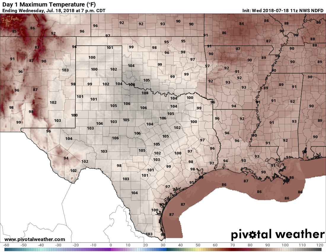
Thursday, Friday, Saturday, and Sunday
More of the same. I expect high temperatures at one point this weekend will reach 100 degrees. Forecast conditions just won’t change much day by day: Heat, sunshine, no rain, high humidity. This is the Houston we know and love. Right?
Next week
The high heat continues for the first half of next week, but there is a chance the high pressure system will break down during the Wednesday through Friday period, allowing for some decent rain chances to return, and for temperatures to fall back into a slightly more reasonable range. It’s something to hope for.

The tropics
The Atlantic tropics are quiet, and no new storms are anticipated over the next five days. Truth be told, this is normal for mid- to late-July, as hurricane season typically does not really fire up until August.
However, there are some hopeful signs out there that would buttress the idea that this year will see near-normal activity overall, or even less tropical activity than normal in the Atlantic—so fewer tropical storms and hurricanes that could potentially threaten the Gulf of Mexico. In a recent update on this season, Phil Klotzbach of Colorado State University noted that:
- The tropical and subtropical Atlantic is currently much colder than normal.
- Odds of a weak El Niño developing in the next several months have increased.
Both of these factors would contribute to reduced activity during the August, September, and October periods.
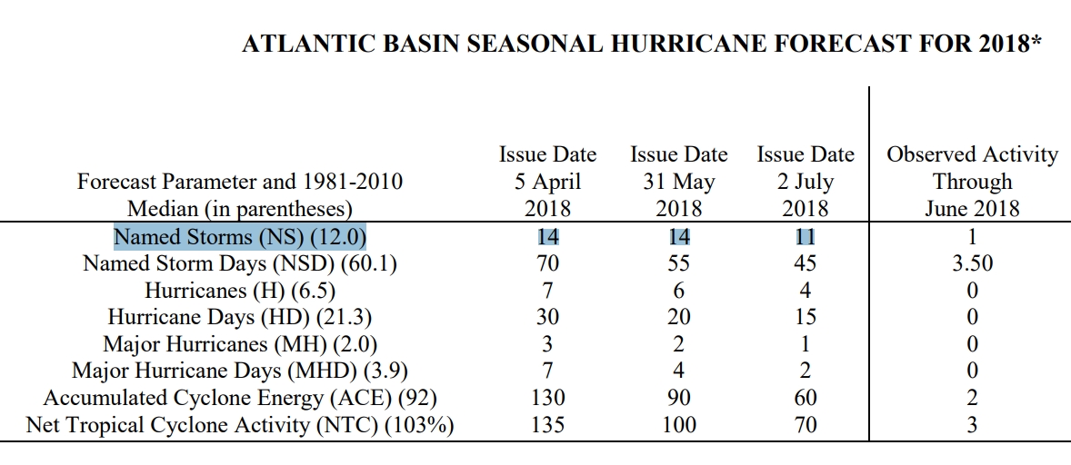
Accordingly, Klotzbach lowered his official forecast from 14 named storms this year to 11, and from 6 hurricanes to 4. It only takes one storm, of course, but we welcome the prospects of a quieter Atlantic hurricane season.
Keeping with the positive, I will note that I was out watering the lawn this morning as the sun came up and it was…. actually kind of pleasant? The humidity didn’t seem so bad and there was a light breeze.
I noticed the same thing today and yesterday, with yesterday being slightly cooler than today even was.
I didn’t notice it yesterday but I definitely noticed it this morning, around 6:30. It was kinda breezy and almost cool, I was shocked.
I agree. As I began walking the first dog at 6:30, it was steamy and then a cool breeze came for the remaining 20 minutes I was out. I was grateful for the blessing it was. But later in the day?… youch!
Pleasant? I think you are suffering from heat-related delirium. 😉
I appreciate your optimism. However, the relative humidity from 3am to 7:30am this morning in Houston was 100 percent.
https://www.wrh.noaa.gov/zoa/getobext.php?sid=KHOU
In contrast to the weather at 10am, it certainly was pleasant. Truth be told, Houston is not that bad at sunrise, or during the twilight hours, even during the dead of summer. It’s just the day part that is pretty brutal.
Do you know the altitude the official humidity is measured?
At my house in Cypress this morning humidity was only 80%, temp around 76 with a slight breeze and it felt very nice.
Please. Please. Please.
Eric – what are the chances for another wonderful cold winter??? Pretty please???
Anyone who can say what conditions will be like this winter, at this point, is lying.
I’d love another cold winter, although a little more sun would be welcome.
Any chance of that big blob of unsettled weather over the Mississippi Delta drifting our way?
“So you’re saying there’s a chance …”
No, I’m not.
Go El Nino! Go wind shear! (to tear up any storms that do form)
Eric, I had a dream the other night that I was reading your daily updates about our first cool front approaching. A dream, indeed.
The mornings (in Conroe) have all seemed hazy this week. Is that the Saharan dust? Is it keeping it a little cooler first thing in the morning?
I understand that an El Nino is probably going to form, however wouldn’t the rapidly warming warm sea surface temperatures in the main development region slow an El Nino’s formation?