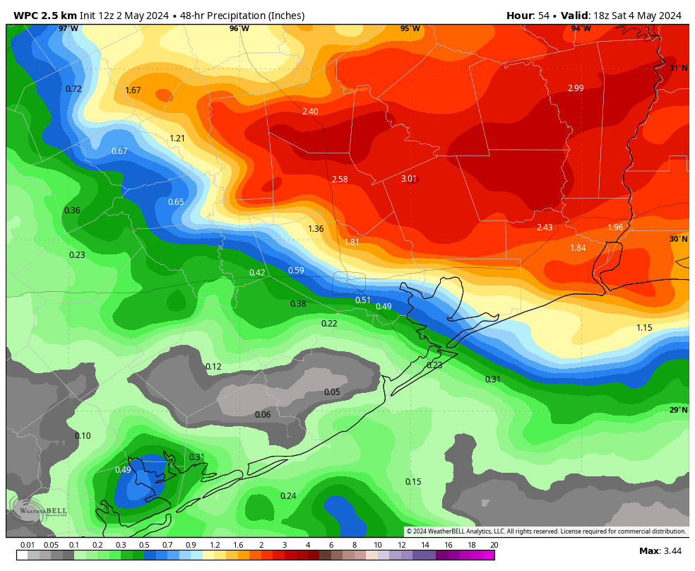
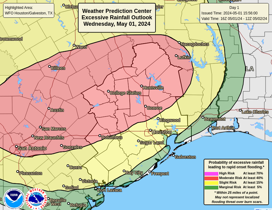
In brief: The heavy rainfall has exited the Houston area, for now at least. The thunderstorms dropped 1 to 3 inches of rain across the southern half of the region, but some whopping totals of up to 8 inches near locations such as Spring and Kingwood during a few hours today. We may see some additional rains tonight and on Friday, but we are confident that the worst is over.
As of about 4:30 pm this afternoon, the mass of showers and thunderstorms that brought widespread rain to Houston today has exited to the east. The atmosphere is now pretty worked over, so we should see fairly calm conditions for the rest of this afternoon and evening. And after that? There is the possibility of scattered showers and thunderstorms returning after midnight, especially for areas south of Interstate 10. Overall these areas have not been particularly hard hit, so I’m not particularly concerned about these storms in terms of flooding. Because the worst is likely over, we are stepping back our flood alert to Stage 1.
We may see another round of showers develop during the morning hours on Friday and persist into the afternoon. Given the messy forecast today, I’m not particularly confident in anything tomorrow. However I don’t anticipate it being nearly so potent as the system we saw today. Matt will have all the details first thing on Friday morning, when we should have the forecast better in hand.
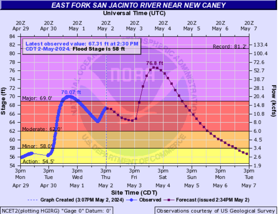
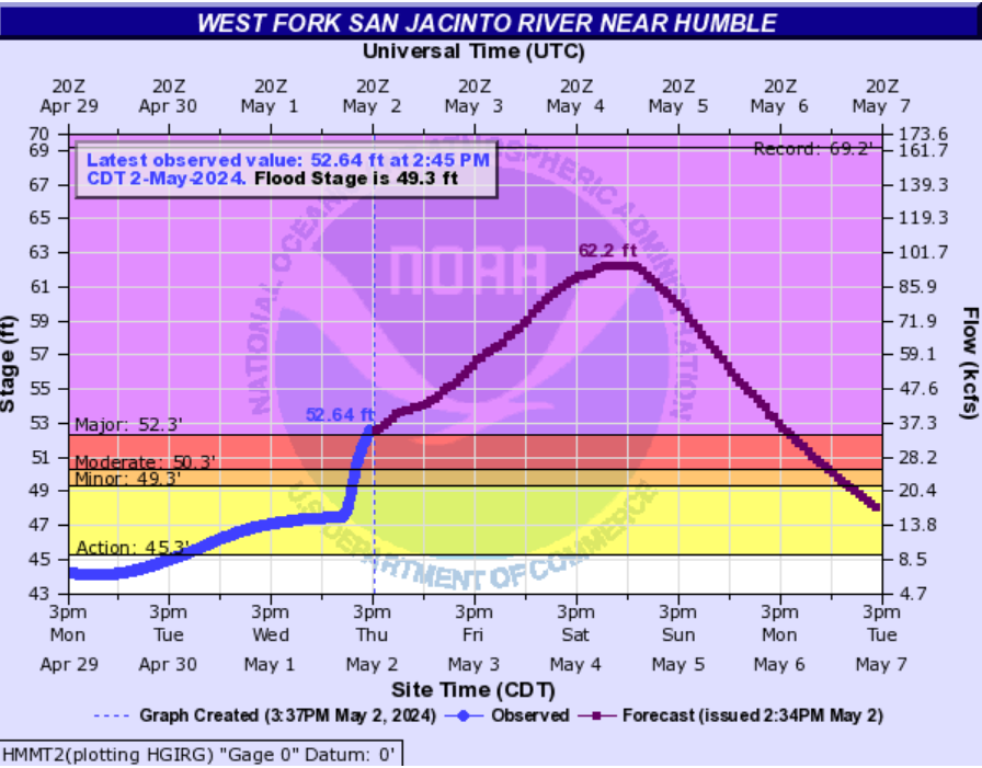
The big story now is river flooding due to the incredible amounts of rain that fell north of Houston this week, including Wednesday night. Lakes Conroe and Livingston were particularly inundated. The National Weather Service has a map where you can find detailed flooding forecasts for various rivers in the greater Southeast Texas area here.
River flooding
Among the biggest concerns are the East and West Forks of the San Jacinto River. Already a mandatory evacuation is in effect for the eastern side of the river, from FM 1485 to Lake Houston. According to Jeff Lindner of the Harris County Flood Control District, forecasted water levels on the East Fork will rise 7 to 8 feet higher than earlier this week. Structures on the ground will be flooded to rooftops levels. Elevated structures will be flooded. For reference, the forecasted water level is only 3 feet below those of Hurricane Harvey.
Conditions are also serious along the West Fork of the river. Lindner says the river is rapidly rising from upstream inflows, and will rise to near 62 feet on Saturday. Widespread low land flooding will occur impacting the following subdivisions: Belleau Woods, Rivercrest, Northshore, Forest Cove, Kings Point, and Atascocita Shores. Flooding of streets in Kingwood, as well as lower structures near the river will also be possible.
If you live in flood-affected areas please do not drive into high water.