In brief: Although considerable uncertainty remains, the potential definitely exists for heavy rainfall across the Houston metro area beginning this evening, and persisting through Thursday. The greatest risk for strong storms is north of Interstate 10, but heavy rain could still develop further south.
We’re continuing to watch for a potential flash flooding event in the Houston metro area later this evening, overnight, and Thursday. This will be driven by a fairly potent atmospheric disturbance that will drive one or more rounds of showers during the next 24 hours. The heaviest rain is likely to fall between midnight tonight and noon on Thursday, so definitely plan to check conditions before venturing out tomorrow morning.
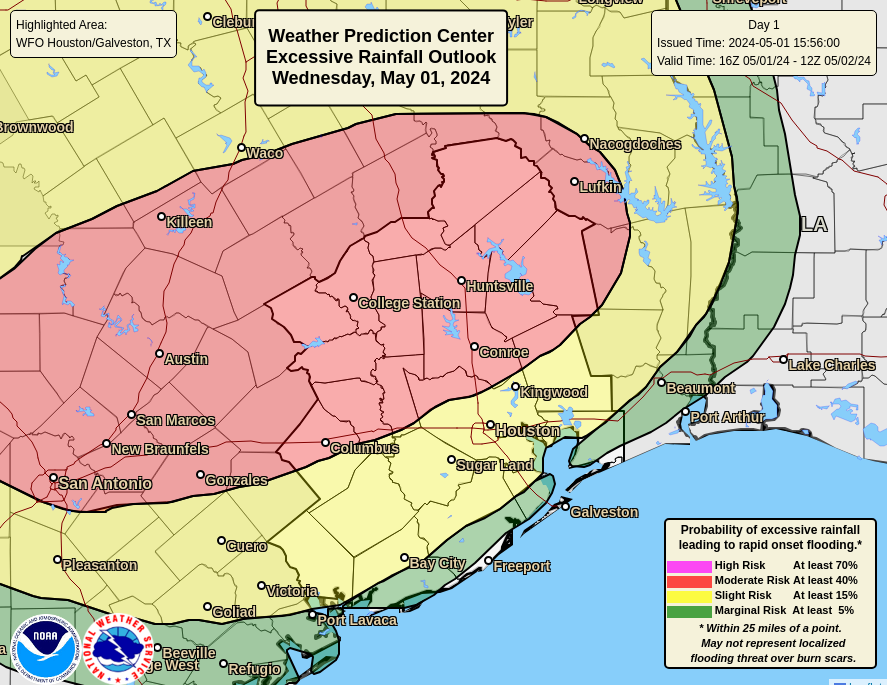
Some of these storms could be severe, with the threat of damaging winds. But primarily, the main concern is heavy rainfall. This is particularly acute for areas north of Houston, some of which already received 5 to 10 inches of rainfall earlier this week. Soils are wet and rivers and creeks are already high. Major reservoirs are full. So these showers will not be particularly welcome.
Generally, I think areas north of Interstate 10 can expect 2 to 4 inches of rainfall through Thursday night, but what concerns me is the potential for higher bullseyes of 6 or more inches. These accumulations will depend upon the speed at which these lines of storms move through, and that’s just not clear right now. For areas south of Interstate 10 the risk is not zero, but it is lower. I’d expect between 0.5 and 2 inches of rain for locations closer to the coast.

This is a difficult forecast because we’re getting mixed signals. On one hand, there is the potential for a pretty heavy rainfall event, especially north of Houston. Yet there are some scenarios in which things don’t fully pan out. So we’re going with a Stage 1 flood alert to raise awareness about the potential for flooding tonight and on Thursday. Things could get worse than that up north, however.
We’ll be back with an update early on Thursday morning.

Is this what you’re calling a May Day?!
We’ve had a seven-year reprieve from serious flooding in Houston since Harvey in 2017. I also remember the Memorial Day flood of 2015 and the Tax Day flood of 2016. Harvey made it three consecutive years of major flooding. Have we started a new cycle where we can expect flooding for the next several years? And, if so, is that due to the pending La Nina due to arrive this summer?
Theres been flooding after 2017 in areas around Houston that are prone to flooding
TS Imelda raising her hand.
You’re right about Imelda in 2019. I had forgotten about that one because it didn’t affect me or my neighborhood in SW Houston (Meyerland area). We had been inundated by the storms in 2015, 2016 and 2017 when Brays Bayou overflowed into our streets. The bayou has since been widened by Harris County FCD and several new bridges built that don’t impede water flow. I don’t wish that kind of flooding on anyone. Wherever you are, stay safe.
Thank you guys for keeping us informed about what to expect and what to not expect. Hope this night is not as noisy as earlier in the week. Grandbabies need a good night sleep before school tomorrow. 🤗
Always appreciate your narrative and sometimes comedic style in your forecasts. You are my go to weather source and I’ve recommended your site to many friends. Keep the good work going…we need Spacecity and you have a lot of fans!
agreed 😊
Eric, can’t resist. Should Katy evacuate?
Houston won’t get much if anything at all it looks like. Perpetually capped
I’ve been watching future radar on TWC app and it’s like there’s a force field around Houston. At first I thought it was just a glitch in the radar because it didn’t look like the storms were going around us so much as they being truncated.
It is a glitch. Now it has a big line of storms about to hit us at 5 AM.