In brief: Houston has largely been spared by heavy rainfall during the last two days, but the story has been different to the north of our region, especially along and north of Highway 105. This could change beginning late Thursday night, when the city of Houston will see the potential for heavy rainfall. Next week still looks rather hot.
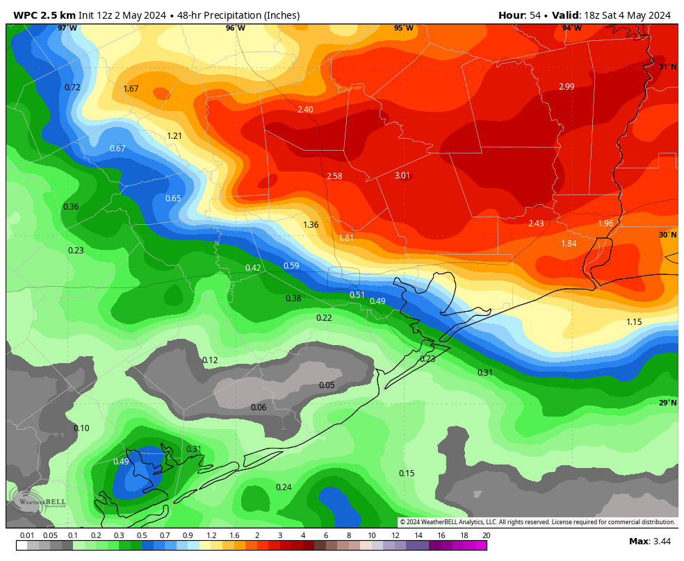
It has been a wet and stormy night for areas north of Houston, including locations such as College Station, Huntsville, and Livingston. Since Wednesday evening, accumulations for areas north of Lake Conroe and around Lake Livingston have reached 7 to 10 inches, leading to flash flooding. This is certain to lead to additional, significant downstream flooding along the San Jacinto and Trinity rivers during the coming days.

So far Harris and surrounding counties have been spared by the latest round of showers. Although the atmospheric conditions supporting heavy rain remain most favorable for locations north of the Houston metro area in the coming days, some of this activity will push southward. At this time, the most likely period for heavy rainfall across the Houston metro area will now come early on Friday.
To that end we are maintaining a Stage 1 flood alert for the Houston area today and Friday. For the northern locations described above, the regions around the lakes Conroe and Livingston, we are definitely approaching Stage 3 conditions on our flood scale. But I want to be clear that, for now, we don’t expect that kind of flash flooding conditions in the Houston metro area. It really has been a sharp gradient in rainfall. For example, during the last two days The Woodlands has recorded less than one-quarter of an inch of rain. Less than 30 miles to the north, New Waverly has received nearly 8 inches.
Thursday
I expect the band of heavy rainfall to the north of the Houston metro area to persist through the morning hours before there is some weakening. It will likely move slightly south, covering much of Montgomery County, but it should be diminishing in intensity through the morning hours. Later this afternoon I expect to see some scattered showers and thunderstorms pop up across Houston, but at this time they don’t look too terribly organized. For the most part, in the city of Houston and points south, we should see partly to mostly cloudy skies with muggy air and highs in the mid-80s. There likely will be a bit of a break from showers this evening for the area.
Thursday night into Friday morning
While there is the usual uncertainty, it does appear as though another round of showers and thunderstorms will develop later on Thursday night, likely after midnight. At this time there is a greater likelihood of rainfall across most of the Houston area, including locations south of Interstate 10. Roughly speaking, there is the potential for an additional 1 to 4 inches of rainfall accumulations, with the risk for higher totals running from the wee hours of Friday morning into the middle of the day.
There could be some higher bullseyes. I don’t feel overly confident in the details of this forecast, so expect an update on this website later this afternoon as we get better data. The bottom line is that it could be a wet night for Houston, but I’m not guaranteeing it. Because of this potential for additional rain tonight into Friday, we’re holding on to the Stage 1 flood alert for the entire Houston area.
Friday
We probably will see the heavy rainfall threat ending later on Friday, so expect partially clearing skies to go along with highs in the low- to mid-80s during the afternoon hours.
Saturday and Sunday
The weekend, for the most part, should bring partly sunny skies and modestly warm weather to Houston. Look for highs in the mid-80s. While rain chances overall in Houston are quite low, they are not zero. Unfortunately, chances appear to be a bit higher for locations north of the city, including the hard hit areas north of Highway 105 described above. To be clear we’re not talking about inches and inches more of rain, but there will be the potential for additional showers and thunderstorms this weekend.
Next week
We’re still looking at the warmest weather we’ve seen so far in 2024 next week. Expect highs in the low-90s by mid-week, with plenty of humidity to make it feel rather warm out. It’s not full on summer, but it will definitely feel hot since it’s been half a year since we’ve felt heat like this. There is a chance, but only a chance, that we may see a final, weak-ish front trail into the area some time next weekend to bring us some drier air. A man can hope …

as I predicted our never-ending CAP kept everything away from Houston including areas “north of I-10” — should have known better as I didn’t water the plants thinking we’d get at least some rainfall.
I just watered my plants hopefully some rain will fall soon.
…,,so you’re saying there’s a chance??? (weakish cool front)
How in the world did the hi-rez models get the forecast so incredibly wrong yesterday and last night for areas west of Houston??
You just answered your own question. It is a forecast model. It won’t always be correct.
Just got really, really dark in Klein and now the thunder is starting to boom!
It’s been pouring here for about the last 45 minutes or so. Crazy!
Must be nice
The storms are always “north of I10” which really means Huntsville, College Station and The Woodlands these days. Anyone else notice this? I fail to understand why Houston weather people can’t say “north of the beltway” instead of “north of I10” but I guess that doesn’t garner as many clicks.
Probably because the beltway runs north, south, east and west – it is a circle – whereas I10 runs east and west, hence, referring to areas north or south of I10 makes perfect sense.
I am both North and South of the Beltway. Unfortunately it would be too confusing with the phrasing.
Howling screaming circular winds, hail on the porch and sheets of rain – another lovely morning spent in the closet in N Hou. I hope it eases up.
“So far Harris and surrounding counties have been spared by the latest round of showers”
This is said as if we don’t want the rain??? Who writes this?
Someone who doesn’t think 8 inches of rain in less than 24 hours is a good thing?
No rain here, old chap.
Exactly
The warm air aloft is still blowing in from the plateau. The upper level ridging at 19000 ft is arriving next week and it may become persistent. Any rain now is welcome. But my sympathies are with NoFH up there.
Are the storms (at 10:15 AM Thurs) at Brenham and La Grange the stuff Metro Hou gets overnight Thursday into Friday?