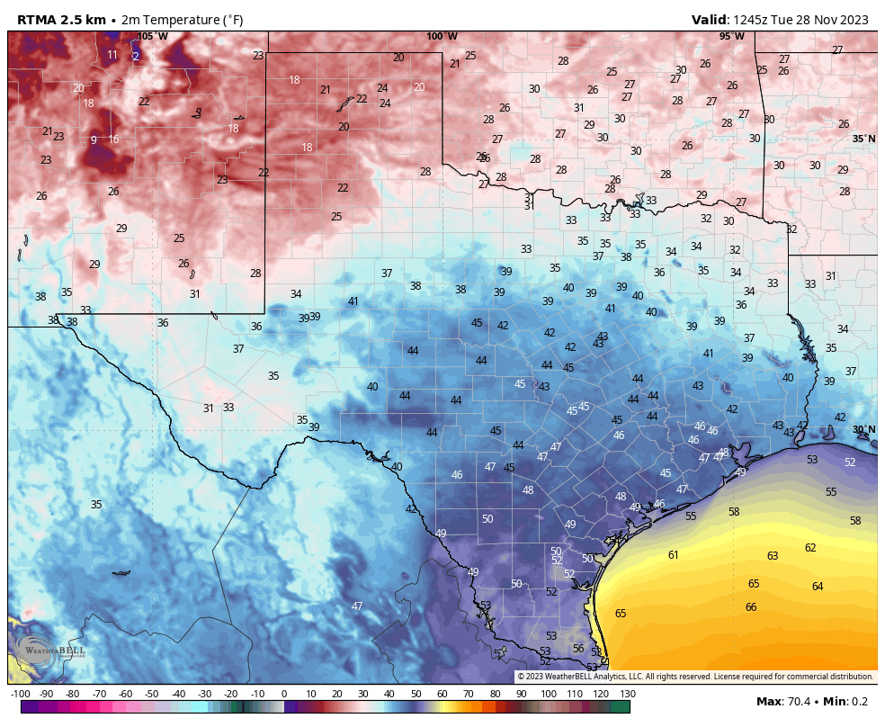
On a chilly morning like this, it is not difficult to imagine that winter will begin soon. But could spend this entire post discussing when winter begins. Is it Dec. 1? Is it the winter solstice, Dec. 21 this year? Is it the region’s first freeze? For the sake of simplicity, since this is a weather website, we’re going to use “meteorological winter,” which encompasses the months of December, January, and February. That works well for Houston because that is, invariably, when the region’s coldest weather visits us.
The big driver for our weather this winter will be a robust El Niño in the equatorial Pacific Ocean. This warming of the equatorial Pacific Ocean will almost certainly persist throughout winter. When El Niño is present during the winter months, it generally has a pronounced effect on the Pacific jet stream. Instead of being variable in its track, often entering North America near the state of Washington and southern British Columbia, it more consistently tracks into California and Mexico’s Baja peninsula. This brings a more southerly storm track, including over Texas.
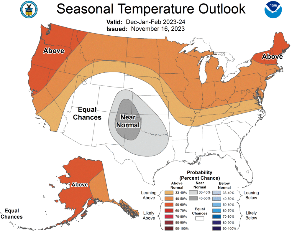
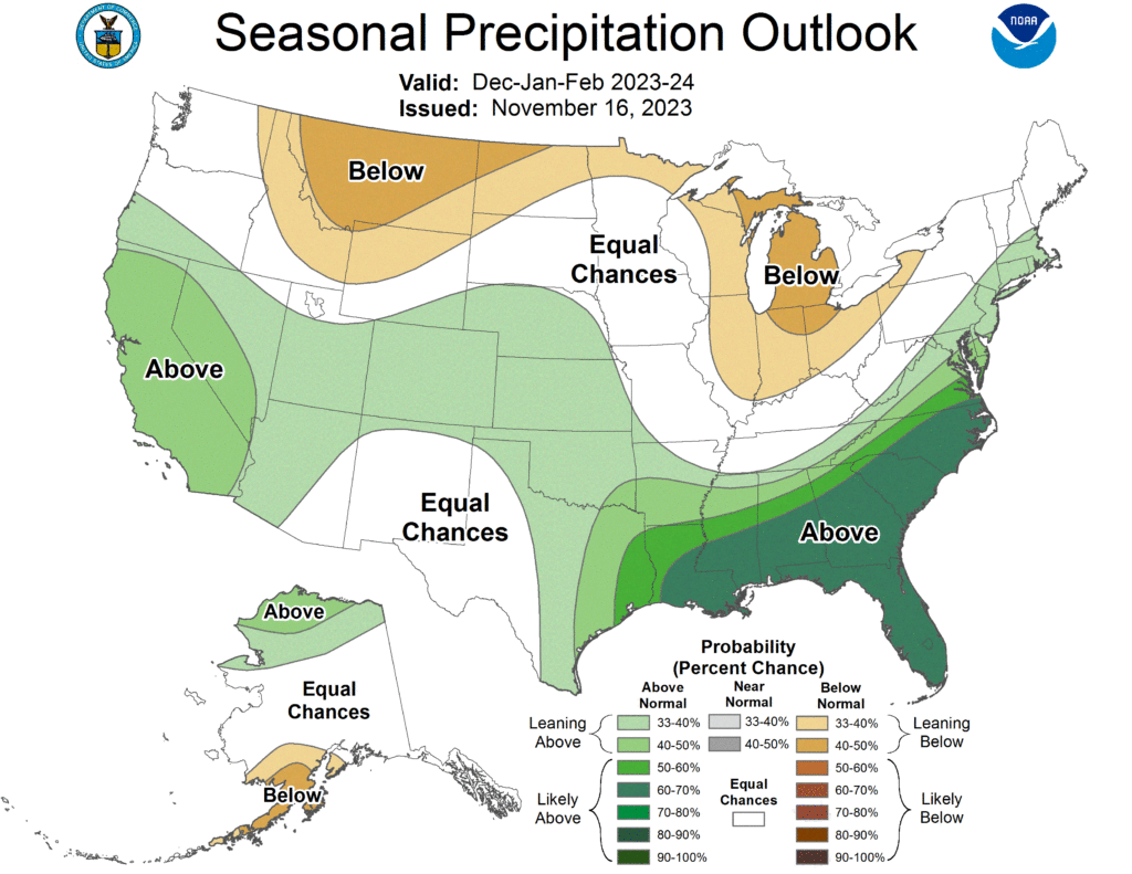
This should make for a fairly straightforward forecast for Texas, including the Houston area, during the winter time months. There is, however, one risk that I’ll discuss below. But first, the outlook. According to NOAA (and historical trends during El Niño), we can expect near-normal temperatures this winter in Texas.
Additionally, given the more southerly storm track, we can expect more precipitation this winter. Note I said precipitation, as during the winter months we can see rain as well as the potential for sleet, snow, and even freezing rain. In any case, since the atmosphere overhead is likely to be more disturbed, this should make for a fairly wet winter. That should help take care of our lingering drought, especially along the Sabine River area.
So that’s what we can expect during a typical El Niño winter. But there is a wild card at play, and that is the lingering effect of very warm temperatures this year (driven largely, but not exclusively, by climate change). As long-time readers will know, the interaction between land and sea temperatures is a crucial part of weather forecasting, and the sea surface temperatures are out of whack right now.
A non-nominal El Niño
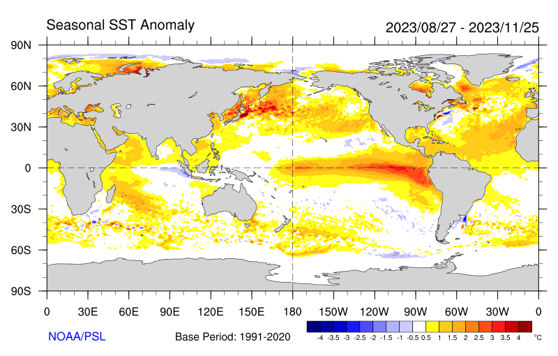
Here’s what I mean by that. The map below shows the sea surface temperature anomaly this fall. Clearly we can see the warmth in the equatorial Pacific Ocean due to El Niño. But much of the northern Pacific and Atlantic Oceans are also very warm, which is not normal leading into an El Niño winter.
Now let’s compare that to what sea surface temperature anomalies were like during the last four strong El Niño events, 1982-83, 1997-98, 2009-10, 2015-16, during the period of November to March. This is what sea surface temperatures have looked like during the last four winters, so it is basically what we should expect to happen this winter if all else were equal.
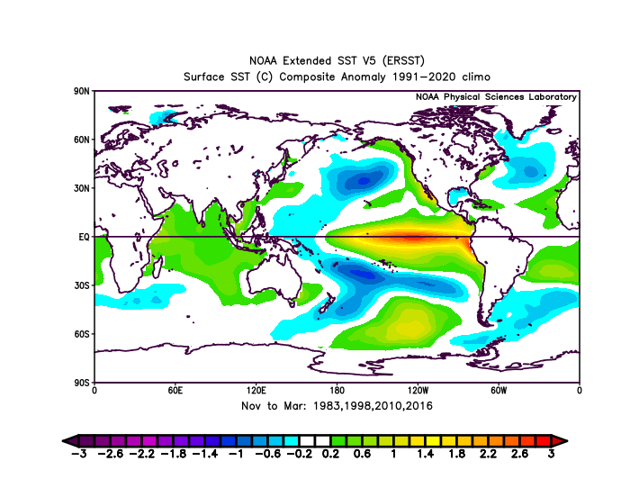
But all else is not equal. I realize we’re doing a bit of comparing apples to oranges here, but the basic takeaway should be clear: Northern Hemisphere sea surface temperatures heading into this winter look almost nothing like they would during a typical El Niño winter—they’re much warmer. Therefore I would rate this winter forecast as low-confidence, with a high amount of risk.
A message from our sponsor, Reliant
We’re always grateful to Eric and Matt for keeping us informed on the forecast! On this Giving Tuesday, we’re showing our gratitude by supporting local nonprofits and helping our customers do the same! The holiday season can be wildly busy and sometimes that giving spirit gets inadvertently pushed down a never-ending to-do list. But now, Reliant customers can spread cheer to those in need by simply cooking dinner or turning on their holiday lights! How?
After enrolling in one of Reliant’s two new Choose to Give plans and selecting a nonprofit, customers don’t have to lift another finger to ensure a steady stream of support is headed to their favorite charity. For every customer, Reliant will donate an initial $100 contribution plus 5 percent of the customer’s monthly energy charges will be contributed annually to provide continuous support. The program launched with two plans benefiting the American Heart Association and March of Dimes. Additional nonprofits are expected in 2024 and customers will have the opportunity to recommend organizations to join the Choose to Give program. Learn more at reliant.com/choosetogive.