Houston’s early 2023 humidity will break today with the passage of a front

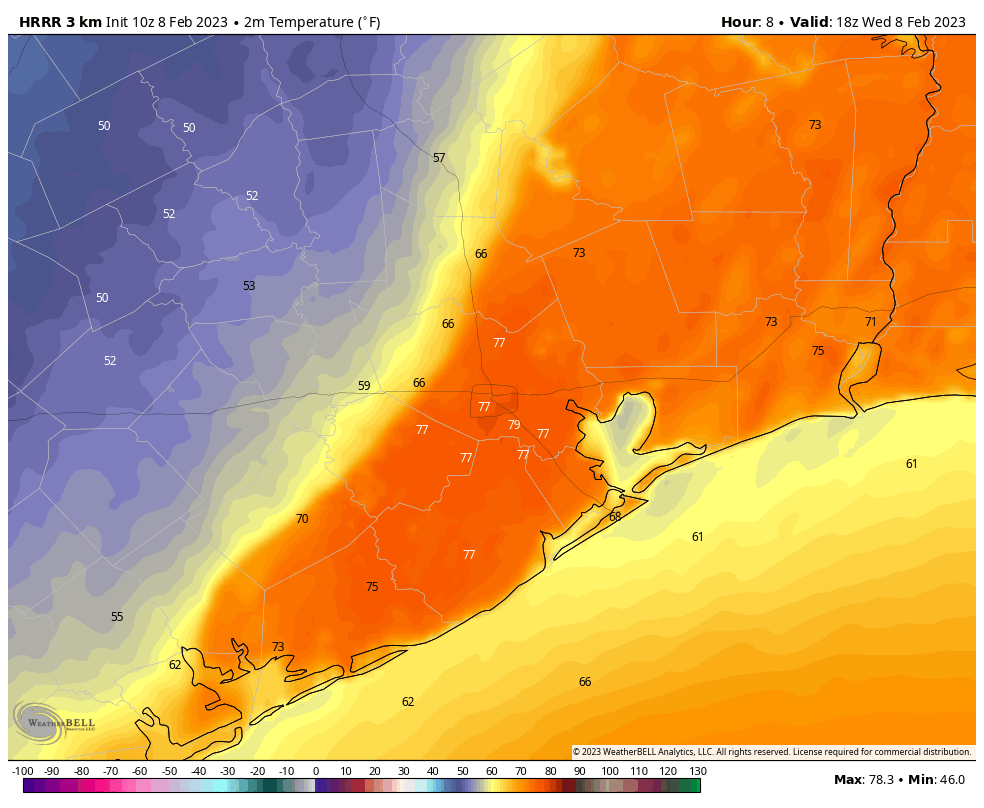
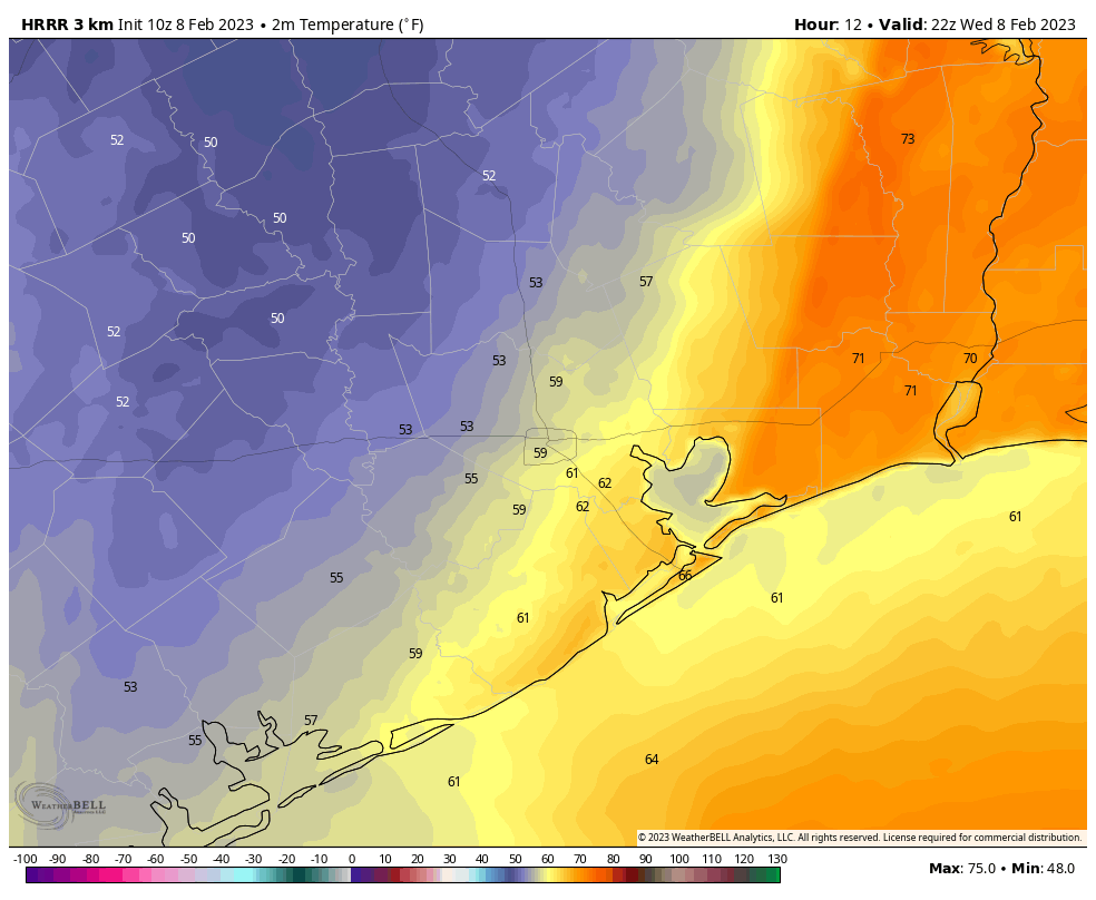
Good morning. A cold front is moving into Houston this morning, which will knock down the very sticky humidity the region has experienced for the last several days. Some storms will persist south of Interstate 10 this morning, but by mid- to late-morning drier air will be replacing this moisture, and bringing an end to rain chances. We’ll then be rain-free until the weekend, when the forecast turns more complex as another front slogs into the area.

Tuesday

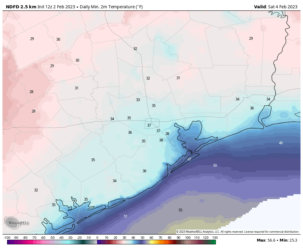
Skies will clear out later this morning, and we’ll see a pleasant, sunny day with temperatures around 70 degrees. Winds will be out of the north or northwest at 10 mph, with slightly higher gusts, so this won’t be a howling front in that sense. Lows tonight will drop down to around 50 degrees in Houston, with colder conditions in outlying areas.

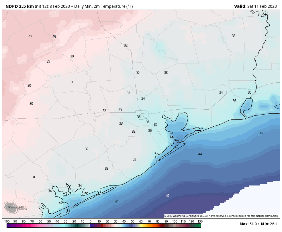
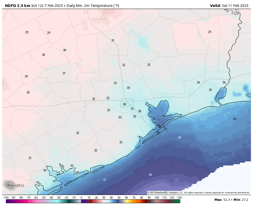
Low temperatures on Wednesday morning will be quite different from 24 hours earlier. (Weather Bell)

Wednesday and Thursday

These will be fine January days, with highs in the upper 60s to 70 degrees, and lows in the upper 40s. Days will be sunny, and nights clear. Winds, generally, will be light.

Friday

As high pressure moves away from the area, the onshore flow will resume. Nevertheless, for most of Friday we should see sunny skies, with highs in the low 70s. Clouds will start to build Friday night, with lows dropping only to around 60 degrees, or slightly below that, in Houston.

Saturday and Sunday

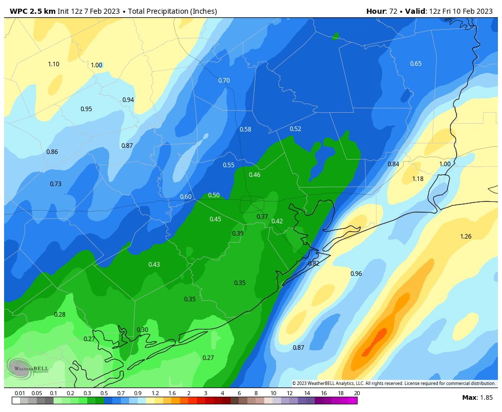
The forecast for the weekend is starting to come into better focus. What we’re likely to see is a slow-moving front push into the Houston and generate widespread rain showers. At this point I think skies will be mostly cloudy on Saturday, with perhaps a 30 percent chance of rain. The better chances will come into the forecast on Saturday night and Sunday. High temperatures on both days will likely be in the 60s, with lows in the 50s. I don’t think these will be flooding rains, but more likely showers and a few thunderstorms of the light- to moderate variety. Most areas should see on the order of 0.75 to 1.5 inch of rain, give or take, spread out over one to two days.

NOAA rain accumulation forecast for the period from Saturday morning through Monday morning. (Weather Bell)

Next week

As the aforementioned front continues to linger over or near Houston, rain chances will likely persist into Monday morning before we finally clear out some behind the front. Most of next week looks pleasant for January, with highs in the 60s or low 70s, with lows in the 40s and 50s.

Storms are possible late tonight ahead of a decently strong front

Happy New Year! The year 2023 has started out warm, but a front will arrive on Tuesday morning to bring more seasonal conditions back into the forecast. Ahead of the front, we have some concerns about the potential for thunderstorms and severe weather later today and tonight, but overall the dynamics are not too supportive for this.

Monday

With very warm conditions this morning, and lows only in the low 70s, we are seeing some sea fog developing again. This should burn off by mid-morning, leaving us with a cloudy day and highs in the upper 70s. Two things we’ll be watching for today: strong southerly winds and the potential for thunderstorms. The winds are pretty much a certainty, as the onshore flow responds to high pressure over the central United States. We’re going to see gusts up to 30 or 35 mph this afternoon. As for the storms, I’m guessing a capping inversion in the atmosphere will limit activity, but you should be aware that there is the potential for some storms to break through the cap later this morning and early afternoon. The potential for rain lingers tonight as lows drop into the upper 60s.

The potential for severe storms today and tonight is greater to the northeast of Houston. (NOAA)

Tuesday

Our second chance for storms will come late tonight and Tuesday morning ahead of the actual cold front. A (broken?) line of showers and thunderstorms should push into areas northwest of Houston around 3 to 5 am, the metro area around 5 to 7 am, and off the coast by around 10 am. For some people, this will be the first day commuting back to the office for awhile, so be aware you may need some extra time due to the potential for storms if this timing is accurate. The skies will clear pretty quickly after the storms, so we can expect clear skies and highs in the low 70s on Tuesday afternoon with notably drier air. Lows drop to around 50 degrees on Tuesday night, with colder conditions further inland.

Wednesday, Thursday, and Friday

Our weather settles down for the rest of the week, with mostly sunny skies and highs in the mid-60s to 70 degrees. Lows will generally be in the mid-40s through Thursday night before a warm-up heading into the weekend.

Saturday and Sunday

The high pressure system that will bring sunny weather during the second half of the work week will slide eastward by Friday, setting up a warmer and potentially wetter weekend. At this point I think Saturday will be mostly rain-free, with partly sunny skies and highs in the mid-70s. Sunday has a better chance of rain, perhaps 30 percent, and at this point I’d guess we’ll see mostly cloudy skies and highs of around 70 degrees.

Conditions will cool down to more seasonable temperatures by mid-week. (Weather Bell)

Next week

I’m afraid there is not a whole lot of certainty in the forecast by around Sunday and beyond. I think the most likely scenario is that a cold front moves into Houston and essentially stalls, setting up a pattern of a few colder, and rainy days. But do I feel highly confident about such a scenario? I do not.

Looking ahead to the weekend of January 14 to 15, a few people have asked me about conditions for the Houston Marathon. At this point there is a decent signal in the global models for a slightly stronger front toward the end of next week, so I’m thinking we’ll see start line temperatures in the 40s. The good news is that right now it does not look too warm or too muggy. The bad news is that a forecast for 13 days from now is about as helpful as cramps at mile 20.

Much warmer this morning, with storms possible tonight ahead of a mild New Year’s holiday

Good morning! It is remarkably warmer this morning across Texas and Louisiana, in some cases more than 30 degrees above lows from just 24 hours earlier. Aside from this dramatic warm-up, the big story for the next couple of days is our rain chances later today and tonight, and then mild conditions for the New Year’s holiday.

24-hour temperature change as of Thursday morning at 6:30 am CT. (Weather Bell)

Thursday

Starting with lows around 60 degrees, we’ll warm up into the upper 70s today with mostly cloudy skies. With ample moisture in the atmosphere and an inbound disturbance, there will be a chance of showers and thunderstorms today, perhaps around 50 percent. But the greater chance of storms will come late this afternoon, evening, and during the overnight hours. These storms will be hit or miss, I think, with some areas picking up just 0.25 and inch of rain, but nearby areas seeing 2 or even 3 inches. Areas that see the heaviest rainfall may experience minor street flooding.

Likelihood of excessive rainfall on Thursday and Thursday night. (Weather Bell)

Friday

Rain chances likely end during the pre-dawn hours. A weak front will the slide into the region on Friday, so we likely will see partially clearing skies during the afternoon with highs in the low-70s. Winds will be light, shifting to come from the north. Lows on Friday night will drop into the low 50s.

New Year’s Eve

The final day of 2022 will be a fine one, with mostly sunny skies, moderately dry air, and highs in the mid-70s. Temperatures at midnight will be mild, about 60 degrees, with perhaps a few clouds in the air. Celebrate the new year outside, and safely!

Temperatures as you celebrate the start of the new year. (Weather Bell)

New Year’s Day

The first day of 2023 will be a bit warmer, with highs in the upper 70s to 80 degrees, and partly sunny skies. Lows on Sunday night will only drop into the upper 60s, and perhaps only briefly.

Monday

This will be a wet, and potentially stormy day ahead of another cold front. Details are to be determined, but we’re likely to see 1 to 2 inches of widespread rainfall. The question is whether all of the dynamics in the atmosphere line up to favor severe storms, and for now I think the answer is that such conditions are more likely to the northeast of Houston, rather than over the city itself. We shall see. Otherwise expect highs in the upper 70s.

Rest of next week

Most of next week will probably see highs in the 60s, with lows in the 40s and 50s. There looks to be a fair amount of sunshine as well. So overall, the first week of 2023 looks to be fairly nice. Hopefully one might be able to say that about the whole year.

Holiday lights

We’re in the final days of being able to enjoy the holiday light shows at Space Center Houston and the Houston Botanic Garden. Here’s a review we wrote of these attractions earlier this year. You can find more information about each there, along with a discount code to save you $5 on each ticket.

Get ready to be jacket-free to start 2023

Although it remains chilly this morning across the Houston metro area, with lows in the upper 30s and lower 40s, by this afternoon the last 10 to 12 days of frigid weather will be but a memory. Looking ahead, it probably will be at least a week before we see lows in the 40s again, and there is no likelihood of a return to the 30s any time soon.

Wednesday

Winds have shifted to come from the south, and they’ll pick up in intensity later today, gusting as high as 25 mph. This influx of warmer and more moist air will allow for a mostly sunny and warmer day, with highs in the mid-70s. Low temperatures tonight will only drop into the mid-60s.

Low temperature forecast for Thursday morning. (Weather Bell)

Thursday and Thursday night

Building upon this moist air, an upper level disturbance will move into the region, bringing a chance of widespread showers and thunderstorms. I don’t have great confidence in how this will all play out, to be honest. I expect mostly cloudy skies on Thursday, with highs in the mid-70s. There will be a chance of scattered showers during the day time, but it looks like the more organized activity, if it develops, will do so overnight. There is a slight risk of heavy rainfall for the region, especially for areas east of Interstate 45, and for places like Beaumont and Port Arthur. Although we cannot rule out some isolated street flooding where such heavy rain falls, I don’t expect much of that. Note that these storms could be hit or miss, with some areas picking up less than 0.25 of an inch—particularly the western half of the metro area—and other areas 2 or more inches.

Friday

This should be a mostly cloudy day, with a high in the mid-70s. At some point a weak front will push into the metro area, and this will help to drop temperatures into the mid-50s on Friday night.

New Year’s Eve

This looks like a fine, mostly sunny day with highs in the mid-70s. The front will knock some of the humid air away. Conditions on New Year’s Eve look pleasant, with temperatures around 60 degrees by midnight, and at least partially clear skies. Rain is not a concern for any holiday celebrations. The start of the new year will be, dare I say, mild?

An early look at the temperature forecast for midnight, at the start of New Year’s Day. (Weather Bell)

New Year’s Day

The first day of 2023 will be warm, with highs in the upper 70s to possibly 80 degrees, and mostly sunny skies. Overnight lows will only drop into the mid-60s.

Next week

The combination of more moist air and the next front will produce widespread showers on Monday, which will be another warm day. After that, look for pleasant conditions, with partly to mostly sunny skies, highs of around 70 degrees, and lows of around 50, for much of the week.