Houston will continue to see splendid winter weather for awhile, with no major temperature or precipitation concerns. Instead, we’ll see a sustained stretch of sunny days, with moderate days and cool nights. Enjoy!
Tuesday
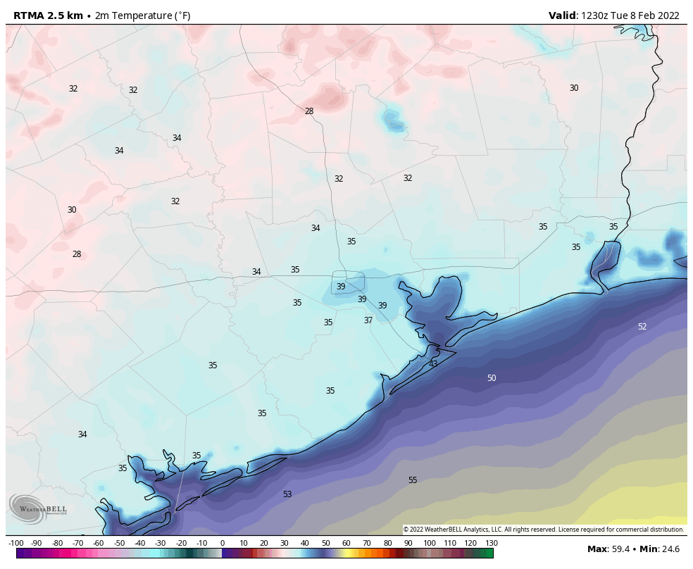
It’s cold out there this morning, but as light winds shift to come from the south later today, we’ll see high temperatures nudge up to the mid-60s beneath sunny skies. This should also help to moderate low temperatures a bit tonight, probably keeping most of the metro area at 40 degrees, or above.
Tuesday’s low temperatures, shown above just before sunrise, should be the coldest morning for the rest of this week. (Weather Bell)
Wednesday, Thursday, and Friday
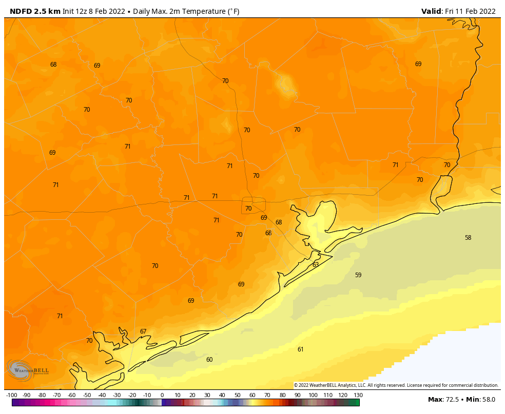
Overall, a fairly cool and dry air mass should remain in place over South Texas. Highs will generally be in the upper 60s on these days, with light southerly and southwesterly winds. Overnight lows will generally be in the 40s, although by Friday night they may only drop to around 50 degrees in Houston. Dewpoints will remain comfortably dry. Skies will be sunny, with nary a chance of rain. This is great weather for picnics, field trips, outdoor classrooms, or anything else out of doors.
Much of the area may see highs of 70 degrees by Friday. (Weather Bell)
Saturday and Sunday
The weekend forecast is coming a little bit better into focus, although there are still some questions about the details. In the big picture, a fairly strong cold front is likely to move through Houston during the daytime, perhaps after noon. So it’s likely that most parts of the region will see a moderately warm morning, and then have things cool off with the frontal passage. Some brief, light rain is possible during Saturday along with the front’s passage, but I think that’s still very much an open question. Winds will probably be breezy on Saturday night, perhaps gusting to around 20 mph, with temperatures dropping to around 40 degrees in Houston. Highs on Sunday should be in the 50s, with mostly sunny skies and a northerly breeze.
Next week
After a chilly start, I think we’ll see a more robust warm up next week with highs returning to the 70s. Widespread rain chances return to the forecast sometime after Monday as well.
Good morning. After a dynamic week of weather, with widespread rain showers Monday, a smidgen of freezing rain on Thursday, and then very cold weather through the weekend, conditions will moderate this week. However, it’s still going to feel winter-like out there, for Houston at least. Normal temperatures for this time of year are highs in the mid-60s, and low in the mid-40s, and that is more or less what we’re going to see.
Monday
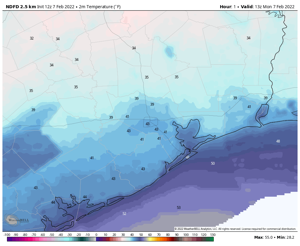
Just as temperatures are beginning to warm, we’ll see another shot of cold air today. This will be more of a reinforcing front rather than a blustery affair, so while winds will shift to come from the north I’m not anticipating anything too gusty. High temperatures should reach about 60 degrees this afternoon, especially after clouds clear out this this morning and leave us with sunny skies. Monday night should be the coldest of the week, with lows dropping into the 30s for the metro area.
Low temperatures on Monday night across Houston. (Weather Bell)
Tuesday
A pleasant, sunny day with light winds. Highs will generally be in the low 60s. Overnight lows will be a few degrees warmer than Monday night.
Wednesday, Thursday, Friday
The upper air pattern will support continued calm weather at the surface for Houston. High temperatures on each of these days should slot somewhere in the upper 60s, with mostly sunny skies, and overnight lows ranging from the upper 30s inland, to low 40s in the city, and upper 40s along the coast. This will be a splendid stretch of winter-like weather.
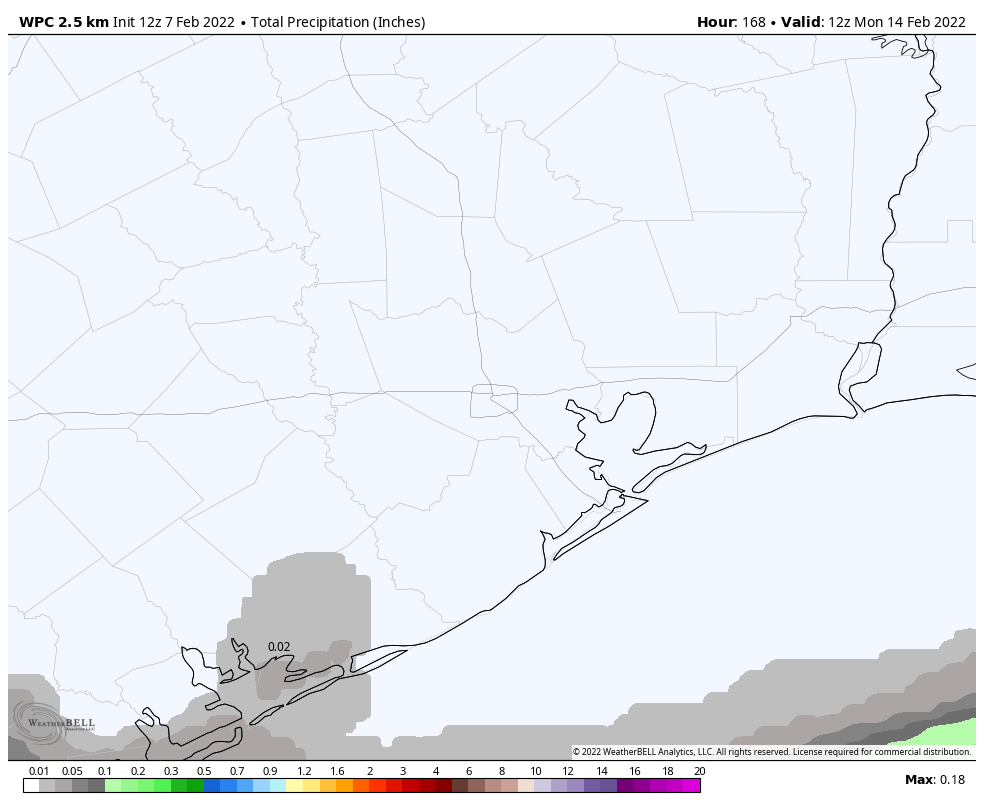
Is it going to rain this week? Not likely, brother. Here’s the rain accumulation forecast. (Weather Bell)
Saturday and Sunday
The forecast for the weekend is somewhat in question due to the uncertain timing of the next cold front. The most likely scenario is that the front comes through some time between Saturday evening and Sunday morning, and for now rain chances do not look terribly high with its passage. But timing and rainfall are both subject to change. Anyway, for now, I’d anticipate partly sunny skies on Saturday with highs of around 70 degrees. Sunday could be quite a bit colder, but for now I’ll go with sunny skies and highs of around 60 degrees. A light freeze may be possible on Monday morning, but I’m not sure this front will go that cold. We’ll see!
It’s cold, wet, and windy outside today, and conditions aren’t going to improve as skies darken tonight. So let’s jump into the forecast for our region.
As of 3 pm CT, temperatures in the metro area have remained above freezing in Harris and surrounding counties. But they are falling, and for places like Katy and The Woodlands the mercury could reach freezing by around sunset. As roads will remain above freezing for a little while, even if these areas start to see some freezing rain, I think conditions should be generally fine for the evening commute as long as you’re not driving further north than Conroe, northwest of Hockley, or west of Katy. Beyond those locations there may start to be some ice accumulations. You can keep up with highway conditions at DriveTexas.
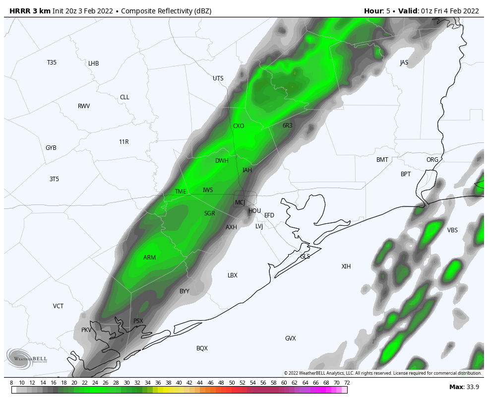
HRRR model forecast for Houston’s radar at 7 pm CT Thursday. (Weather Bell)
As for tonight, a light band of precipitation should move through the region from northwest of Houston to the coast between sunset and midnight. This may turn over to freezing rain at some locations where temperatures reach freezing. My sense right now is that the precipitation will be light enough, and the roads warm enough, that the primary concern will be patchy ice on bridges, ramps, and elevated roadways. We should have a much better sense of this threat later this evening, and Matt will have an update by or before 9 pm. The good news is that, after this point, the precipitation is probably over for areas inland of Highway 59/Interstate 69. So by late this evening we should have a sense of whether ice is going to pose problems for that portion of the Houston metro area tonight and into Friday morning.
Coastal areas
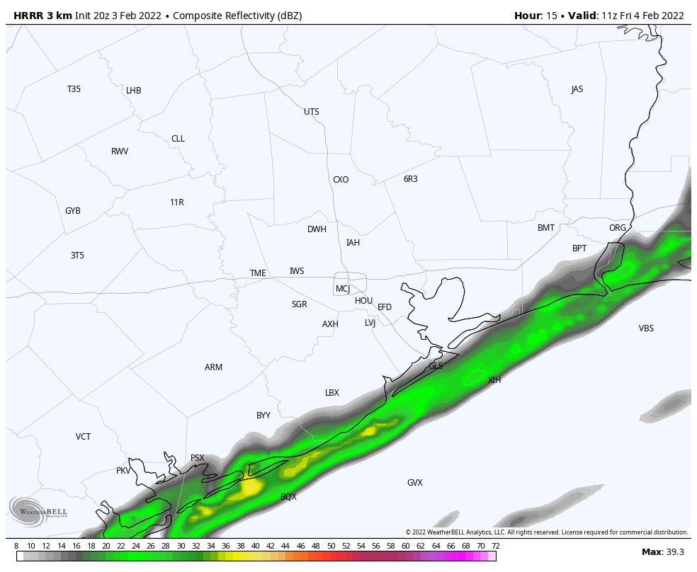
That leaves us with coastal areas. Temperatures should be warmer during the initial rain band, moving through before midnight. So we don’t think there’s much potential for icing then. However forecast models are showing the potential for the redevelopment of some light precipitation by around sunrise on Friday morning in the coastal tier of counties—Matagorda, Brazoria, Galveston, and Chambers. Frankly I don’t have great confidence in whether these showers will develop onshore or offshore; nor if they are over land whether the atmosphere will be cold enough to produce freezing rain. For now, I would say the chance of roadway impacts is considerably less than 50 percent on Friday morning, and probably less than 10 percent, but as of now it is not zero. Hopefully we’ll get a little better handle on this by the time Matt posts later this evening.
HRRR model depiction for radar activity at 5 am CT Friday. Will these showers be onshore or offshore? Cold rain or freezing rain? Stay tuned. (Weather Bell)
As for temperatures, they still look cold but manageable tonight, with lows likely dropping to around 25 degrees west and north of metro Houston, into the upper 20s to 30 degrees in the city, and to around freezing right along the coast. The state’s electricity grid seems to be holding up fairly well, too, but the acid test will come overnight and into Friday morning.
Good morning. The cold front has pushed off the coast, and temperatures have fallen into the upper 30s to low 40s for most of the region. Our primary concern remains the potential for rainfall to turn into wintry precipitation this evening, and during the overnight hours. Secondarily, we are worried about cold temperatures on Thursday night falling below freezing, with wind chills in the low teens. Please protect your pets, and check on neighbors.
Thursday
Today will be cold, wet, and windy, with light to moderate precipitation winding down through the morning hours. Expect high temperatures to remain at about 40 degrees or slightly higher this afternoon, with northerly winds gusting to 25 or 30 mph. Rain remains possible this afternoon, although showers should be very light. There are two main forecast questions that we’re struggling with, and they’re both important to determine impacts from later today into Friday morning. First of all, how quickly will a freezing line advance from northwest of the Houston metro area down toward the coast? And secondarily, when will the precipitation end altogether?
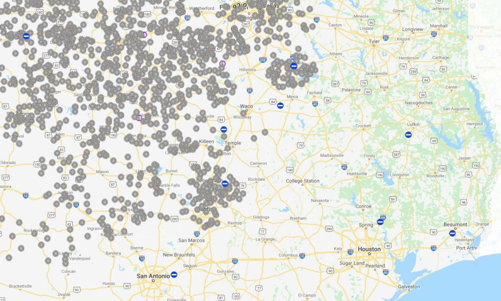
Most likely, the freezing line will reach western parts of the metro area, including Katy; and northern parts, including The Woodlands; sometime this afternoon or shortly after sunset. This means that travel through Houston should be fine today and likely through the evening commute unless you’re going north of Conroe or to places northwest, beyond Hempstead. For more inland parts of the state, including Austin and Dallas, there are fairly serious icing problems today. You can check highway ice conditions at the Texas Department of Transportation’s Drive Texas website.
Icy conditions have already developed in central and northern Texas this morning. (DriveTexas.org)
As the freezing line moves in, it looks as though very light precipitation may still be falling this afternoon, evening, and overnight. Our primary concern is that this will leave a thin glaze of ice on elevated roads and bridges into Friday morning. Within the Houston metro area, my sense right now is that essential travel will still be possible if you go slow and use caution. However, it does not take too much freezing rain to make a mess of things. The latest models have trended a bit drier in terms of overnight precipitation, which gives me some hope that ice accumulation is not going to be a significant problem in Harris County and most of the immediate area surrounding Houston. But again we’re walking a pretty fine line here. Matt and I will update the site a couple of more times today to bring you the latest data we have on this.
It looks like overnight temperatures will drop into the mid- to upper-20s for much of the Houston area, with the coast remaining near or just above freezing. Combined with winds, this will make for extremely cold conditions out of doors, but we don’t think it will cause widespread issues with pipes. So far the state’s power grid is holding up well, with electricity capacity far exceeding demand. We think that will continue to be the case tonight and into Friday, but can offer no guarantees.
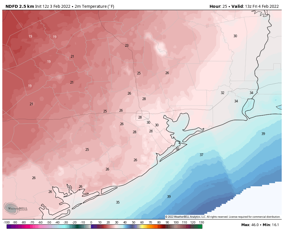
Low temperature forecast for Friday morning. (Weather Bell)
Friday
So what can we expect roadways to look like Friday morning? This will depend on precipitation overnight, and right now our expectation is that there may be a light glaze on elevated roads and bridges. There is a chance for more significant ice accumulations, but as I look at the data right now that seems unlikely. Temperatures should rise above freezing during the mid- to late-morning hours, after which the threat of any ice on the roads will quickly abate. A winter weather advisory from the National Weather Service is in effect through noon Friday. High temperatures on Friday won’t go far—perhaps only to 40 or 42 degrees—but they’ll go far enough. With partly cloudy skies we can expect another cold night, with a light freeze possible in Houston.
Saturday
The first day of the weekend will be sunny and cold, with highs in the upper 40s. Winds should finally die down some, but this in turn will yield ideal conditions for cooling overnight, so a light freeze will again be possible for much of the metro area.
Sunday
Sunny with highs in the mid-50s. Lows Sunday night should finally remain above freezing for all but some areas in Montgomery County and points north.
Next week
For the most part we should see sunny weather next week, with highs in the 60s and lows in the 30s and 40s. Rain chances are low for the most part. So cold, but not extremely cold.