Tropics Update: Fred in the Gulf, Grace headed there

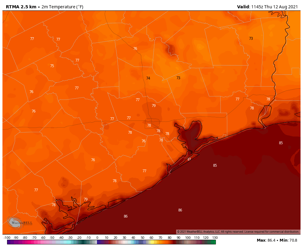
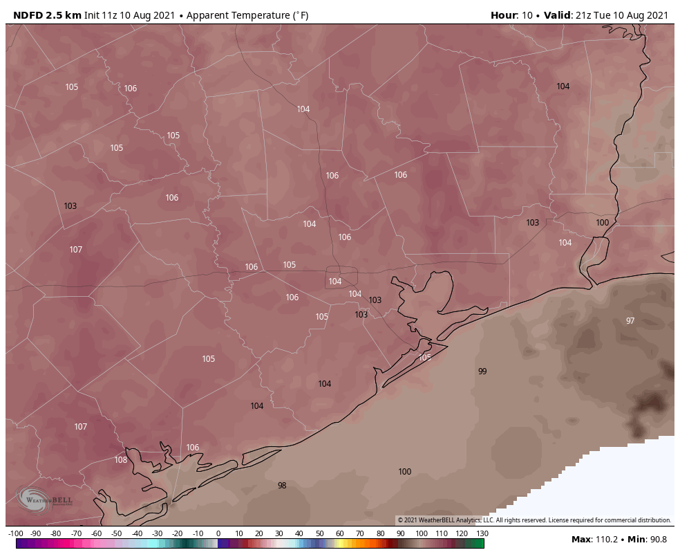
Good morning. A “cool” front has essentially stalled across the metro area, and this will lead to partly sunny conditions today and Monday, with about a 50 percent chance to rain to go along with temperatures in the low- to mid-90s. Some rains today could briefly pulse up into strong thunderstorms, so be weather aware if you are outdoors.

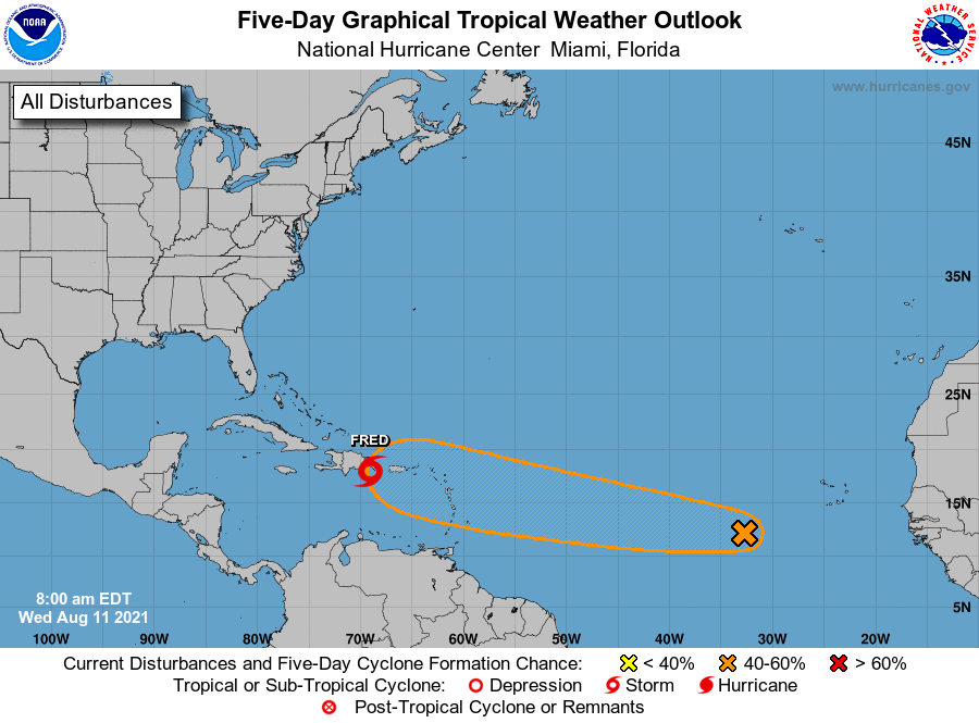
The main purpose of this post, however, is to discuss the tropics and impacts to the Gulf of Mexico. We have had lots of questions over the last day because a single model run of the GFS on Saturday appeared to bring “Hurricane Grace” toward Texas late this week. We cannot emphasize this enough: a single model run, especially an outlier, should always be looked up with a high amount of skepticism. Anyway, herein is what we know as of Sunday morning about Fred and Grace.
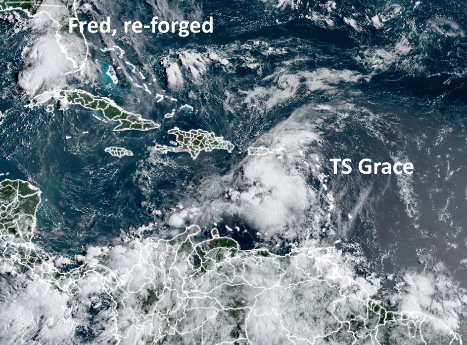
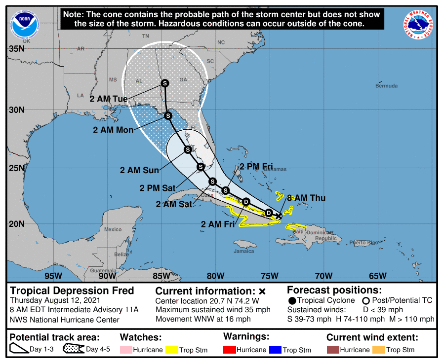
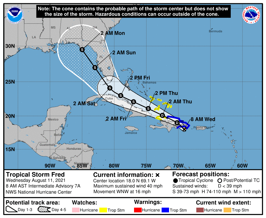
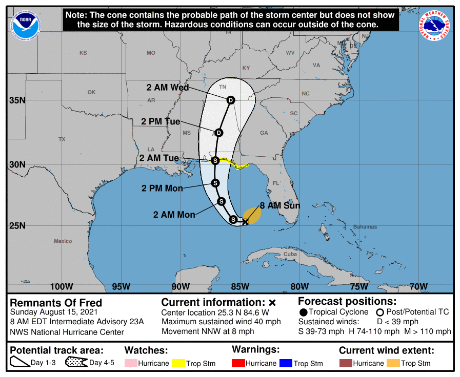
Satellite image showing tropical storms Fred and Grace on Sunday morning. (NOAA)

Tropical Storm Fred

Fred has re-formed in the southeastern Gulf of Mexico, and confidence is fairly high that it will get pulled north later today, and head toward Alabama and the Florida Panhandle. Fred could become a strong tropical storm before landfall, so there may be some wind impacts in the Panhandle to go along with several inches of rainfall. By Tuesday afternoon it should be moving well inland and weakening quickly.

Track forecast for Tropical Storm Fred. (National Hurricane Center)

Tropical Storm Grace

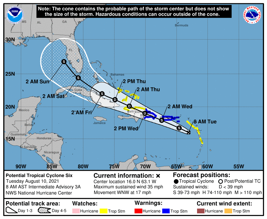
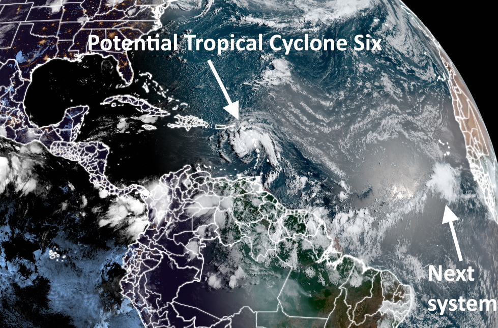
For our purposes, Grace is the storm of more interest, although the forecast is highly uncertain. As of 8am CT on Sunday morning, Grace is rather disorganized and barely a tropical storm. Its center is south of Puerto Rico and likely to move onshore Hispaniola (which is two countries, the Dominican Republic and Haiti) during the next 24 hours. After a devastating earthquake on Saturday the last thing Haiti needs is a tropical storm, but that is nonetheless what is coming on Monday.

Forecast track for Tropical Storm Grace. (National Hurricane Center)

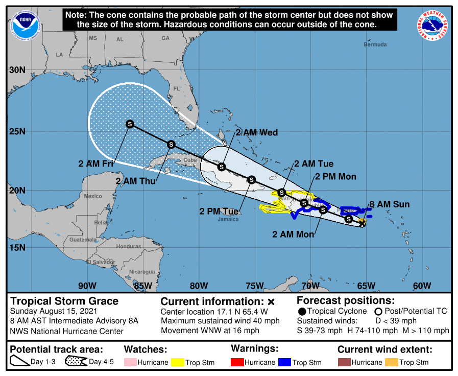
The first real question is whether Grace survives its interactions with Hispaniola and Cuba from Monday through Wednesday. I think there is probably at least a 50 percent chance the tropical system gets shredded by the terrain of these two large Caribbean islands.

However, if some low-pressure center emerges into the Gulf of Mexico around Wednesday, what happens then? The environment in the Gulf of Mexico, in terms of dry air and shear, will be OK but not ideal for intensification. I would put the chance of Grace ultimately becoming a hurricane in the Gulf of Mexico at about 10 to 20 percent. That is a rough estimate based upon ensemble forecasts, and is only to help you calibrate your own expectations right now.

In terms of track, Grace is really hard to pin down because a) its center is ill defined, b) this center will likely to jump around as it interacts with land and/or re-forms in a new location, and c) where it would ultimately make landfall in the Gulf of Mexico is a forecast still 6 to 8 days from now. However, should a center survive interactions with the Caribbean Islands and emerge into the Gulf next week, I expect it would move more generally westerly, toward Texas or Mexico, with impacts perhaps next weekend.

European model ensemble forecast for Tropical Storm Grace. (Weather Bell)

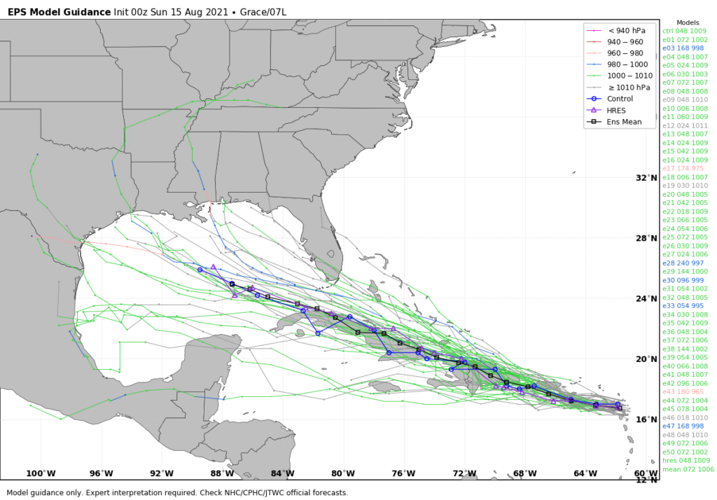
However I can’t stress enough the uncertainty with all of this, and that there will probably be some wild swings in model forecasts in the coming days.

The bottom line is that we’re in the middle of August, and this is a time of year when we are always watching the tropics keenly. Any time there is the possibility of a low-pressure center entering the Gulf of Mexico during August we need to monitor it. And we will. But for now the overall chance that Grace becomes a serious and direct threat to Texas remains fairly low.

We’ll have a full update on Houston’s weather and the tropics on Monday morning.

Hot as usual, with a continued chance of scattered showers

Houston will continue to see hot summertime weather, but with the absence of dominant high pressure the region will also see scattered rain chances each day. The pattern changes slightly on Sunday, as a weak “cool” front pushes into the area. This may spark heavier rainfall in some areas, but the details remain sketchy.

Sunrise temperatures in Houston on Thursday. Just another morning in paradise. (Weather Bell)

Thursday

Some fairly sporty showers popped up over parts of the Houston region on Wednesday, and we could see that again today with fairly high atmospheric moisture levels. I think coverage will probably be about 30 percent, with areas east of Interstate 45 having a better chance of seeing a shower or thunderstorm. Highs, otherwise, will be in the mid-90s with partly sunny skies. Any showers should end as the Sun sets. Winds will be light, out of the south.

Friday

This should be another hot day, with mostly sunny skies, highs in the mid-90s, and rain chances in the 20 to 30 percent range.

Saturday

More of the same, with a chance of an afternoon shower, sunny skies and highs in the mid-90s.

Sunday

The aforementioned cold front will not be particularly noticeable on Sunday. High temperatures may be a couple of degrees cooler, and dewpoints slightly lower. But it’s still going to feel like summer out there with partly to mostly sunny skies. What the front may do is induce a rising motion in the atmosphere, which would increase rain chances and at least bring the potential for heavy rain into play. I don’t think this rain will be particularly widespread, but a few areas may pick up some stronger showers on Sunday. Hopefully Matt can better pin down the details of this in tomorrow’s forecast.

Next week

We’ll see more August-like heat next week with highs generally in the mid-90s. The main question remains whether the upper-level pattern will spin a few disturbances toward Houston, and thus some reasonably healthy rain chances, or keep us mostly dry. The jury is still out on this, I’m afraid, although I’d welcome a somewhat wetter pattern as things have really dried out this month.

Tropics

Not a whole lot has changed. Fred has weakened into a tropical depression overnight, but its main threat was always going to be rain anyway so that’s not really a big deal. It still should regain tropical storm status as it moves away from Cuba, and should bring 2 to 8 inches of rain to parts of Florida this weekend.

Forecast track for Tropical Depression Fred. (National Hurricane Center)

Invest 95L is the tropical system further out in the Atlantic. This system most likely will follow a track similar to Fred, although we can’t entirely rule out a more westerly path into the Caribbean Sea. Either way, the atmosphere isn’t overly favorable, so it seems likely that 95L may struggle to intensify much as Fred has.

All in all, for Texas in mid-August, things look pretty good in the tropics right now. We have about six weeks left in the “prime time” of tropics season for our state.

Heat continues, Fred forms, and clear skies for Perseid meteor shower

Good morning. Our overall forecast remains more or less the same, with hot August weather on tap for days and days and days. Some relief may be found in scattered to isolated storms, but overall rain chances for most parts of the region remain about 20 percent each day. I’ll say more about the tropics below, but for now I wanted to mention the Perseid meteor shower. This celestial event, often the best of the year, peaks Wednesday night and Thursday morning.

The best time to see the show will be during the pre-dawn hours of Thursday. The forecast is favorable, with clear skies likely. For those of us in Houston, the biggest problem is always finding a wide-open dark sky. Our metro area is simply bright with all of its development. I’ve included a map of the region, at night, taken about five years ago from space to help guide you toward some darker skies.

Be prepared to find dark skies at night near Houston. (NASA)

Wednesday

The National Weather Service has posted a heat advisory for today in Houston, but if you’ve lived in the region for any period of time, conditions will not surprise you. Highs will be in the mid- to upper-90s with lots of humidity and mostly sunny skies. The heat index will peak during the afternoon hours, so limit your exposure at that time. Winds will be light, out of the southeast. As with recent days there will be a few scattered showers this afternoon, but your overall chances of seeing rain are probably about 20 percent.

Thursday and Friday

Not much changes toward the end of the work week, with continuing highs in the mid-90s and lots of sunshine.

Saturday and Sunday

The weekend will bring more of the same, in terms of heat and humidity. A “cool” front will push into the region and reach the coast later on Saturday, but you won’t really notice its effect. Mainly, it could serve to increase rain chances later on Saturday and Sunday to perhaps about 30 percent. Skies should remain mostly sunny and I think any showers will be fleeting.

Next week

There’s a chance we may see some better rain chances over the region next week in the Tuesday or Wednesday period, but that’s predicated on an upper-level low sliding south into Texas. I’m not sure that will actually happen, so most likely we’re just going to continue to see hot and sunny weather.

Tropics

Tropical Storm Fred formed on Tuesday evening, and for the most part it’s behaving as expected. The storm will move across the Caribbean Islands this week before reaching the Florida Keys this weekend. After that time it should turn to the northwest and then north. The main impact from Fred, which most likely will remain a tropical storm, should be rainfall. Parts of Florida could see 2 to 10 inches of rain this weekend.

(National Hurricane Center)

Behind Fred there’s another tropical disturbance we mentioned yesterday. The National Hurricane Center now gives this system a 40 percent chance of becoming a tropical depression or storm. Most likely it will follow a track similar to that of Fred, which would preclude it from having any effect on Texas or the Western Gulf of Mexico. But it’s too early to have any definitive comment on that.

Another system follows Fred. (National Hurricane Center)

Our August weather continues with hot but not ultra-hot conditions

Good morning. Houston’s typical weather for August will continue on schedule. That means heat, humidity, and for a lucky, very few, perhaps an afternoon shower. Otherwise we’re going to see highs in the mid-90s for days, and plenty of sunshine. We’re also monitoring the tropics, where “Fred” is likely to form later today.

Tuesday

Torrid Tuesday will see mostly sunny skies, with highs in the mid-90s. Rain chances are probably only about 10 percent this afternoon, Winds will be moderate, at about 10 mph out of the south with slightly higher gusts. Overnight lows will struggle to fall below 80 degrees for much of the area, so it will definitely be sticky.

The heat index will peak at around 4pm CT today. Please take care outside. (Weather Bell)

Wednesday

Wickedly warm Wednesday may see rain chances a little bit higher south of Interstate 10, but otherwise be a lot like Tuesday.

Thursday and Friday

Turned up Thursday and Fiery Friday will see more of the same, with approximately a 20 percent chance of a brief afternoon shower and otherwise hot and mostly sunny conditions.

Saturday and Sunday

Sultry Saturday and Sweltering Sunday—OK, I’ll stop that—should see more of the same. However, rain chances may increase slightly on Saturday and Saturday night as a weak front approaches the region. This front should not change our temperatures much, but may induce enough lift in the atmosphere to bring a 30 percent chance, or so, of rain. Otherwise expect highs in the mid-90s. This hot, August-like pattern should continue into next week.

Tropics

The National Hurricane Center started tracking “Potential Tropical Cyclone 6” on Monday. Why the weird name? This is a relatively new product forecasters use when they expect a storm to form, and want to give residents some warning before the storm is directly upon them. In this case, people living in Puerto Rico, Hispaniola, and Cuba are more aware that a tropical storm is likely to form today. If and when it forms, the storm will be named “Fred.”

Forecast track for Potential Tropical Cyclone 6. (National Hurricane Center)

There is a fair amount of confidence in the forecast track for Fred across the Caribbean Islands, and approaching southern Florida late Friday or early Saturday. After that it probably will go into the eastern Gulf of Mexico, and track toward the Florida panhandle. It’s a little too far out to have high confidence, but the coming weekend does look wet in Florida. Fortunately, due to wind shear, chances are Fred remains a tropical storm rather than becoming a hurricane. But again, time will tell. There is no threat to Texas.

Satellite image from Tuesday morning. (NOAA)

One other system of note is in the far eastern Atlantic, having only recently moved off of Africa into the ocean. Forecast models are fairly bullish on this system eventually developing as it tracks westward across the Atlantic Ocean. A lot of models, including the European, bring this system along a track much like that of Fred, across the Caribbean Islands and toward Florida. However, it is possible that this system follows a more due westerly track, reaching the Caribbean Sea about a week from now. In that case it would become something we would have to monitor more closely in Texas. But that is a long, long, long way off and not worth worrying about at all.