Houston made an abrupt transition from “winter” to “spring” in the middle of February, and the second half of the month was abnormally warm. (Note: On the morning of Feb. 15, we published a blog entry titled, “And just like that, winter is pretty much over in Houston.” Just sayin’). Overall, the month of February ended up being 6 degrees (in Houston) to 8 degrees (Galveston) above normal.
Winter ended on Valentine’s Day. (NWS)
As we get deeper into the spring, we’re going to see fewer cold nights. This week a strong front will push overnight low temperatures back into the 40s for the first time since Feb. 13. If you like the colder weather, enjoy this, because we may only get one or two fronts this strong for the rest of the spring season—before we get into summer proper.
After another humid night across the Houston region, a cold front is sweeping through the city just before sunrise. Only a very broken line of showers is accompanying the front, so most people probably won’t see much, if any rain with the front’s passage. This will set the stage for a few nice days.
Thursday and Friday
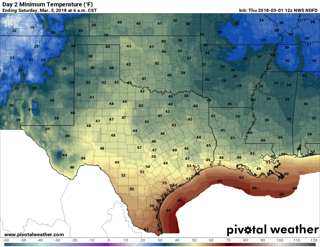
Skies should clear out today, leading to partly or mostly sunny skies in the wake to the cold front. Highs should still climb into the mid- to upper-70s, and it should be a really nice day. We can expect a cool night Thursday night, and very pleasant, mostly sunny conditions again on Friday. Friday night should see our coolest weather of the week, with lows dropping into the mid-40s for areas well inland on Saturday morning.
Low temperature forecast for Saturday morning. (Pivotal Weather)
Saturday
This should be our nicest weekend day in quite some time. We’ll still be partly under the influence of high pressure, which means there should be a fair amount of sunshine as temperatures climb to about 70 degrees. We’ll probably see some clouds move in later in the day, and some slight rain chances enter the forecast later on Saturday night, as moisture levels rise.
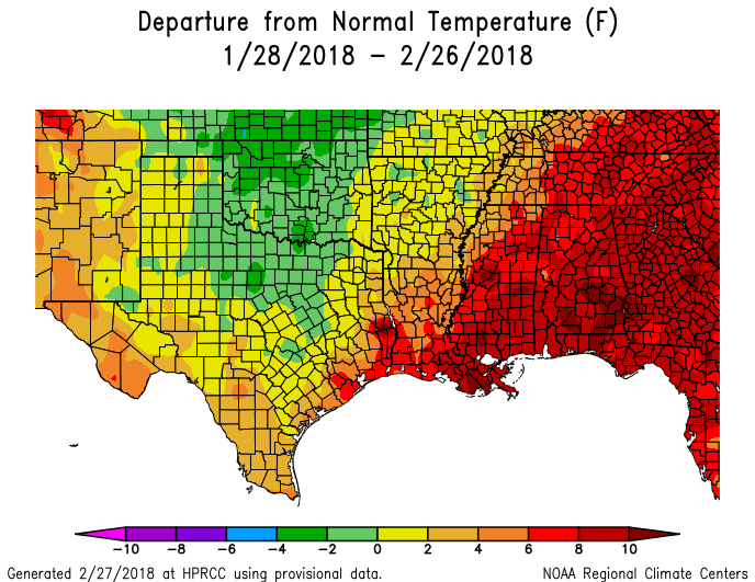
It feels like early June across the city of Houston this morning, with low temperatures only having fallen into the low 70s. Indeed, February has been quite a warm month after the cold start to 2018, and most areas are going to end up between 5 and 6 degrees above normal temperatures for the month. We will probably end up close to, if not among, the top 10 warmest Februaries in the city’s history. The map below shows the departure from normal temperature map for the last 30 days, through Monday.
Departure from normal temperatures map for the last 30 days. (HPRCC)
Wednesday
Highs will reach the low 80s under mostly cloudy skies. We’ll see some brisk southerly winds as warm, humid air continues to move into the area. There’s a slight chance of showers for the northern half of Houston today, but for the most part I think the rain will hold off until a front moves through Wednesday night. The front, with a broken line of showers and storms, should sweep through the area between midnight and sunrise on Thursday, perhaps bringing a tenth of an inch of rain, or two. As spring fronts go, this one should be fairly mild.
Well, that was nice while it lasted. Sunshine broke out across much of the area Monday, making for a beautiful afternoon and sunset. Unfortunately we are already seeing some light rain showers off to the southwest of Houston, and we’ll see more on-and-off rain chances through Thursday morning before we get another outbreak of pleasant weather.
Clear skies to end the day on Monday. (Amanda Berger)
Tuesday
A warm front is moving back onshore, bringing with it humidity and moisture into the Houston area. As this warm front moves inland today, it will generate some scattered showers, which mostly will be light. Under mostly cloudy skies we can expect highs in the upper 70s, with a warm night. Some areas along the coast might not fall below 70 degrees (this will flirt with record high minimum temperatures for Galveston, for this time of year, that were set in 2017).
Wednesday
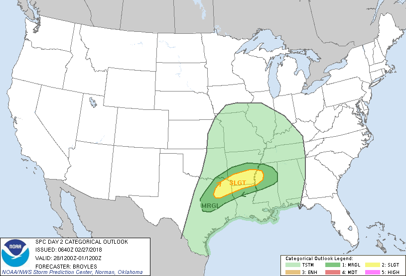
This should be a warm, mostly cloudy day. Despite the absence of sunshine for most of the day, I think we’ll still see temperatures pushing into the lower 80s. A few scattered showers are possible, but I think that rain will hold off for most people until a front approaches the area Wednesday night. There is the potential for severe weather with this system as it moves southward through Texas, Arkansas, and Louisiana, but it appears these storms will remain to the north of Houston, as the air becomes more stable closer to the coast.
NOAA severe weather outlook for Wednesday and Wednesday night. (NOAA)
For Houston, we can expect to see a line of showers and thunderstorms as the front moves through during the overnight hours on Wednesday, and pushes off the coast Thursday morning. Overall rain accumulations should be about one-quarter of an inch, or less, for most people. This is a good thing, as the San Jacinto and Trinity river basins are facing some moderate flood stages.


