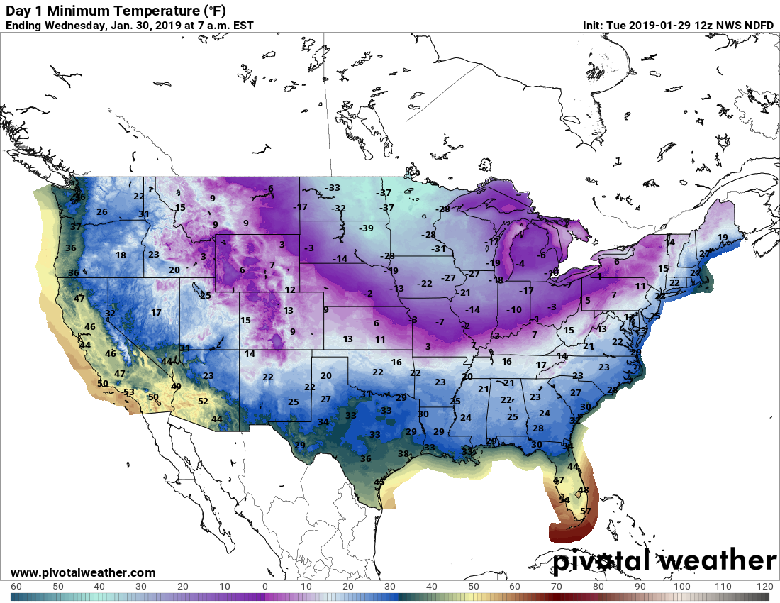
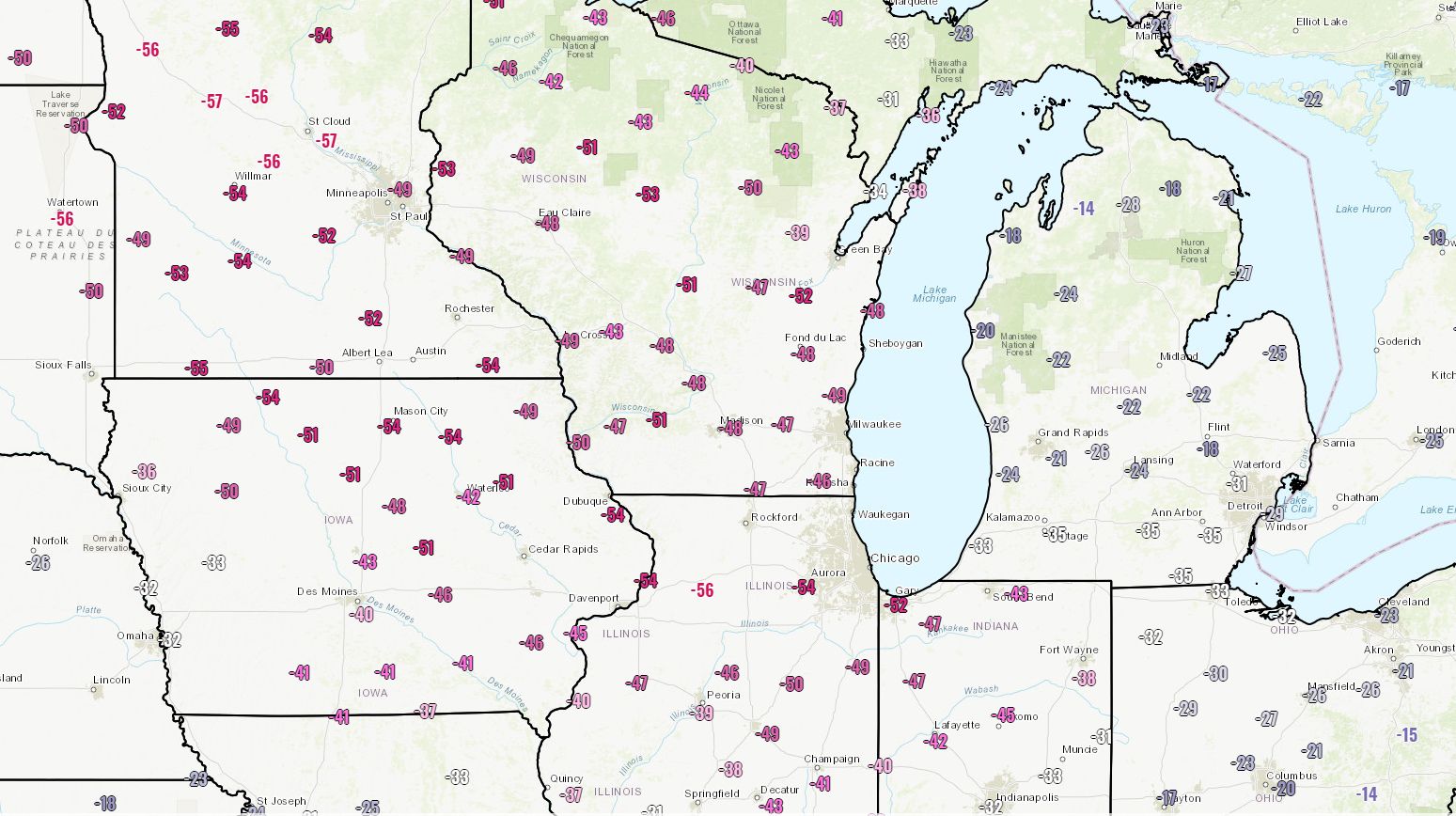
Rain returns this weekend, and Christmas still looks chilly

Temperatures have fallen to freezing levels for some areas north and west of Houston this morning, although most of the city and coastal areas have remained a few degrees above this threshold. It is nonetheless a cold winter morning out there, so don’t forget to bundle up yourself and your loved ones this morning.

Much of Texas is seeing freezing temperatures this morning. (Weather Bell)

Wednesday and Thursday

Sunny skies this morning will help warm things up across the region, with high temperatures today reaching the mid-60s. Lows tonight will probably be 5 to 10 degrees warmer than Tuesday night, so we shouldn’t see any freezes. Another pleasant, partly sunny day is on tap for Thursday with highs in the mid-60s. However, before the weather can warm up too much, another cool front will move into the region on Thursday. There is a slight chance of some rain on Thursday night and into Friday morning along the coast, but as of now I expect the region to remain mostly dry.

Friday

In the wake of Thursday’s front, Friday morning will start out cold, but not freezing for Houston. Temperatures probably will warm only into the 50s under partly sunny skies, and with a cool northerly breeze. Chilly.

(Space City Weather is brought to you this month by the Law Office of Murray Newman)

See full post

Cool and pleasant this week, with a healthy chance of rain Sunday

A cold front quietly moved through Houston during the overnight hours, and this will set the stage for calm, cool weather for the rest of the week. Winter is here, and it will feel like it.

Tuesday through Thursday

Not much to say about these days. We’ll see sunny conditions, with high temperatures in the mid-60s, and chilly nights. Look for lows in the upper 30s to 40 degrees for inland areas, and around 50 degrees right along the coast. We’ll also see some modest northerly breezes on Tuesday in the wake of the front.

Friday

Another front will arrive on Thursday night, probably after midnight, which will lead to a chilly day on Friday. I’d expect high temperatures of around 60 degrees.

(Space City Weather is brought to you this month by the Law Office of Murray Newman)

See full post

Sunny, cool weather this week for Houston. But what of Christmas?

After a cold, winter-like weekend in Houston, temperatures will moderate some. But we’re not going back up to warm, 80-degree weather any time soon, and in reality the overall pattern looks really pleasant for at least the next week or so. At this end of today’s post we’ll also take a preliminary look ahead at weather for the Christmas holiday.

Monday

After a chilly start with lows in the 30s for inland areas and 40s close to the coast, southerly winds and sunshine will allow for highs to warm into the low 70s. The return of a southerly flow will be brief, however, as a cold front pushes into the region—likely sometime between midnight on Monday night and sunrise on Tuesday morning. There won’t be enough moisture ahead of the front to produce any precipitation.

Sure, it’s cold out there on Monday morning. But it definitely could be colder. (Weather Bell)

Tuesday through Friday

Truth be told, there won’t be much change in our weather this week thanks to a front early on Tuesday, and an additional front Thursday. We’re going to see mostly sunny skies, mostly clear nights, highs in the low- to mid-60s, and overnight lows generally around 40 degrees for inland areas, and upper 40s to 50 degrees right along the coast. This is pretty typical weather for mid-winter in Houston.

(Space City Weather is brought to you this month by the Law Office of Murray Newman)

See full post

SNOW WATCH 2017: It’s happening, Houston

Just so we’re all on the same page for this crazy weather, I want you to recall that on Monday—just three days ago—the high temperature in Houston was 81 degrees. And now we are talking about snow. And speaking of snow, here is the scene in College Station on Thursday evening, shortly after sunset.

A winter weather advisory is in effect for northern counties in the Houston metro area (i.e. Waller, Montgomery, and Grimes) where moderate snowfall may stick to some bridges this evening as surface temperatures fall to below freezing. Up to 2 or even 3 inches of snow is possible for some areas in the Brazos Valley area, as the snow continues to fall.

Here’s a look at the radar, showing (in blue) areas of snow as of 8pm.

It’s snowing in Texas. In early December. Radar at 8pm CT Thursday. (Intellicast)

This system is slowly moving to the east-southeast. Short-term models suggest the band of moderate to heavy snowfall that stretches from Austin to College Station to Huntsville in the map above will weaken as it moves into the Houston area later tonight. This perhaps means the central part of Houston will see only flurries, or no snowfall at all. We’re not entirely sure.

(Space City Weather is brought to you this month by the Law Office of Murray Newman)

See full post