The front that pushed into Houston on Monday brought some very dry air with it. The relative humidity level at Bush Intercontinental Airport dropped to 15 percent during the afternoon hours, and Hobby Airport reached 12 percent. These are Arizona levels of dryness, and we can look forward to a few more days which are nearly as dry.
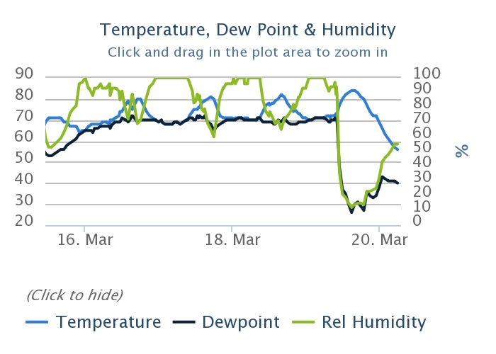
Relative humidity levels (green line) are shown at Hobby Airport for Saturday, Sunday, and Monday. (National Weather Service)
Tuesday and Wednesday
We’re going to have a couple of great, mostly sunny days as the region remains under the influence of northwesterly winds and high pressure. Expect high temperatures in the 70s, for the most part, and lows in the upper 40s for areas well inland (i.e. Montgomery County) and in the 50s for central and southern parts of the region. These will be fine, low-humidity days.
Good morning. I just wanted to say a quick thank you to Matt for covering the site last week while I was on vacation—it felt good to fully unplug for awhile. I am sorry to have missed some great weather last week, however. Now I’m back, and ready for the spring storm season (some northern areas, such as Montgomery County, got a taste of severe thunderstorms on Sunday evening), and summer is lurking around the corner as well.
Monday
The radar is clear this morning across the Houston area, but that should change shortly after sunrise as a cool front approaches the area. I expect a broken line of showers, and possibly a thunderstorm or two, to develop along the front as it reaches Houston during the morning hours, and moves well off the coast by noon. Over the areas they develop, these storms should not produce significant accumulations as they will be fast moving. I was actually hoping for a bit more widespread showers today, because that might help shake some of the extremely heavy tree pollen levels out of the air.
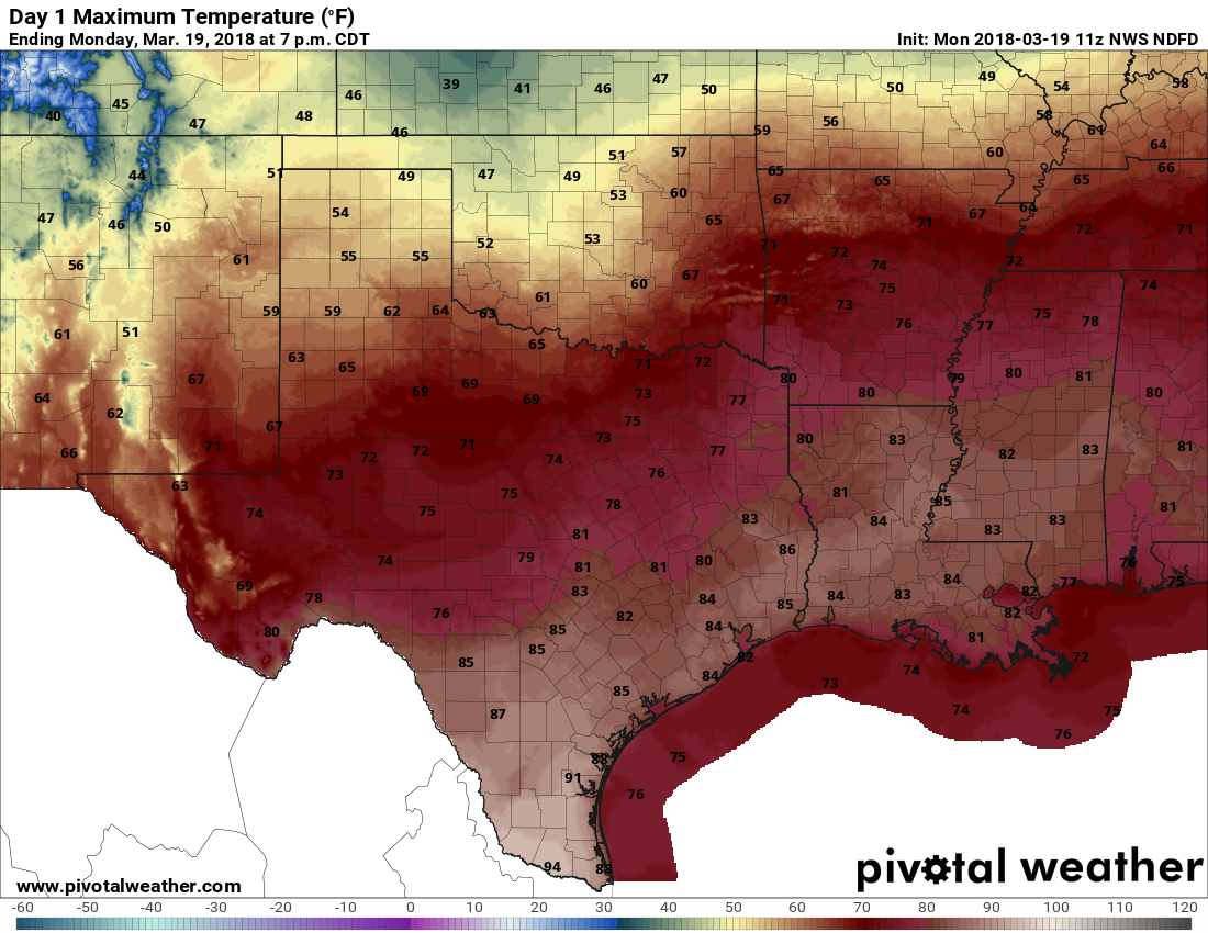
It will be a warm day Monday, but humidity levels will be extremely low. (Pivotal Weather)
With sunny skies today, and very dry air moving in behind the cool front, we should see highs climbing into the low to mid-80s across the area. Given the very dry air mass—humidities could be in the teens across the area—please take care if handling fire as it won’t take much to start a wildfire, and for it to spread. With the drier air, temperatures will drop off pretty quickly tonight as the sun sets.
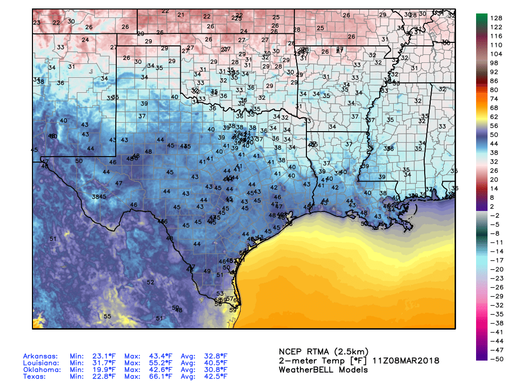
Chilly temperatures have descended across the greater Houston area this morning, with lows generally in the 40s and 50s. This drier air will begin to exit the region as a more moist flow replaces it. This will lead to a general warming trend through Saturday, before the next cold front arrives on Sunday. As discussed on Wednesday, the week of Spring Break still looks pretty fine.
It’s cold in Texas this morning, but not freezing like in some neighboring states. (Weather Bell)
Thursday
The region will see partly sunny skies today, with high temperatures likely in the upper 60s. Some clouds are mixing into our skies, too, and this trend should persist later today as the onshore flow reestablishes itself. Low temperatures tonight will probably be in the 50s for most of Houston, and warmer along the coast.
It’s a cool morning across the Houston region, with temperatures ranging from the mid-40s up north to the upper-50s on Galveston Island and right along the coast. Wednesday night should be even chillier across the region before a warm-up heading into the weekend. We’ll also take a look at the Spring Break forecast for Houston.
Wednesday
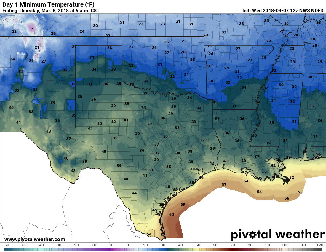
Clear, cool, and sunny with a high in the upper 60s. As additional dry and cool air works its way into Houston today, we’ll have a colder night, and I expect low temperatures to fall into the upper 30s for inland areas, and mid-40s in most of the city. Definitely a fireplace night!
Low temperature forecast for Wednesday night/Thursday morning. (Pivotal Weather)
Thursday
Another nice, mostly sunny day with highs in the upper 60s. We can’t rule out a few clouds as the onshore flow likely resumes sometime later in the day. Nighttime temperatures will probably be about 10 degrees warmer than on Wednesday—so cool, but not cold.