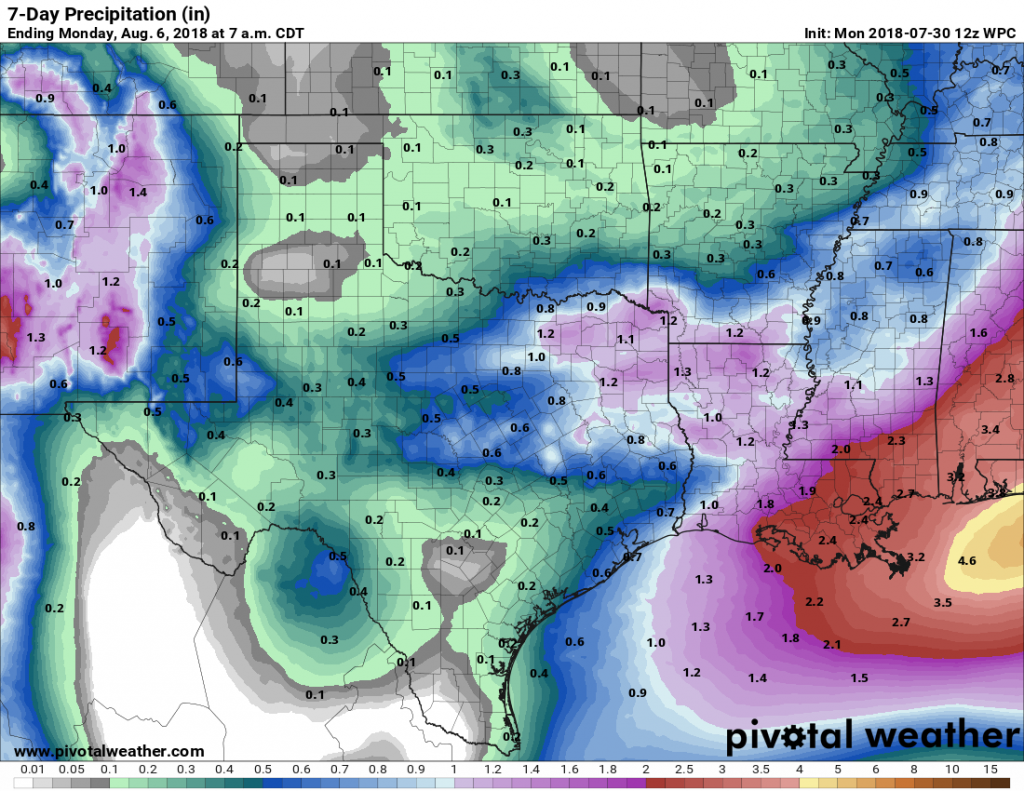
Sunny to start the week in Houston, with an uncertain weekend

Houston had less than an ideal weekend, with storms Friday night and into Saturday morning, a gray day Saturday, and with skies only beginning to clear on Sunday afternoon. I’m sorry to say that next weekend doesn’t look ideal for outdoor activities either—although I wouldn’t bet on a total washout just yet.

Monday

It’s chilly out this morning, with lows ranging from the upper 30s up north to around 50 degrees right along the coast. A reinforcing cold front will move into Houston today, likely before noon, and along with this we’ll see noticeably stronger northerly winds. This will bring drier, cooler air into the region. Expect highs in the mid-60s and sunny skies, with overnight lows tonight in the upper 30s to lower 40s for most of the Houston region. A freeze is possible for far northern Houston.

Tuesday morning will probably be the coldest one of the week. (National Weather Service)

Tuesday

A cool winter day with a high only of about 60 degrees under sunny skies. Overnight lows Tuesday night will be a few degrees warmer than Monday as winds shift from the northeast to the southeast.

Wednesday

A pretty nice day. Moisture levels begin to return, but we’ll still see mostly sunny skies, and highs should climb to about 70 degrees for most of the area.

See full post

A hiccup before more great conditions next week in Houston

We’ll have one more day of sunny, really nice weather before a bit of a hiccup heading into the weekend.

Thursday

Houston will have another great day today, with high temperatures climbing into the mid-60s after a cool start in the morning. With sunny skies and light winds, this afternoon and evening should be a real winner for any outdoor activities. Later today the winds will make a subtle shift from northeast to southeast, and this will start us on a warming trend—especially during the overnight hours—into the weekend. Lows Thursday night will probably be 10 to 15 degrees warmer than the night before.

Friday and Saturday

The forecast turns a bit messier as Houston heads toward the weekend. Moisture will stream inland on Friday, and later Friday night an atmospheric disturbance will move up the coast. At this time the best chances for rainfall will occur near the coast, where perhaps there is a 70 percent chance of rain on Friday night through Saturday, with a lesser chance for inland areas. As the onshore flow picks up there could be a brief spike in moisture levels on Saturday morning that will fuel some isolated, heavy rain showers, but I think most of the area will see rain measurements in the tenths of inches.

Moisture levels, shown here in precipitable water, spike to about 200 percent of normal levels on Saturday morning. (Weather Bell)

Highs will be in the upper 60s on both days under mostly cloudy skies. A cold front will push through later on Saturday, or during the overnight hours, which will bring an end to the rain chances.

Sunday and beyond

After the front, Houston will dry out and see some more pretty great winter-time weather. Generally, for the first half of next week, the region should see highs in the mid-60s, with nights in the upper 40s to low 50s. So it will be chilly—but not cold.

Some rain chances return by Thursday or Friday of next week, when the region’s next front seems likely to move through. At this time I don’t expect a freeze for most parts of Houston, but we’ll be watching it for you.

Mostly superb winter weather to prevail for the next week or so

Houston experienced fabulous January weather on Tuesday, and we’ll have a couple of more splendid days before conditions are mixed up a bit this weekend. This is the winter most of us in Houston know and love.

Wednesday and Thursday

Not much changes for the next couple of days, as we see pleasant, sunny days with high temperatures in the low 60s, and overnight lows on Wednesday around 40 degrees—warmer closer to the coast and cooler inland. Thursday night will be milder, as the onshore flow resumes, and moisture levels begin to rise.

After a series of colder nights, Friday morning’s lows will be more moderate. (Pivotal Weather)

Friday

Those rising moisture levels will generate some clouds on Friday, and possibly some light, scattered rain. Even so, the better rain chances probably don’t come until Friday night, when an upper atmospheric disturbance appears likely to move into the region from lower Texas. Highs Friday will probably reach into the mid-60s and you’ll begin to feel the humidity.

See full post

Dry now, a bit soupy to end the week in Houston

The first three weeks of January saw an average temperature about 7 degrees below normal across Houston, but the last week of the month should see weather more typical for this time of year—which is to say not too hot and not too cold.

Tuesday, Wednesday, and Thursday

After a chilly start this morning generally in the 30s across Houston, pleasant winter weather awaits. Under the influence of high pressure, we’re going to see mostly sunny days with high temperatures in the low 60s, dry air, and cool nights with lows in the low 40s—warmer at night along the coast and cooler for inland areas. Clear skies should make for really nice sunrises and sunsets.

Thursday night, Friday and Saturday

By later on Thursday, an onshore flow should resume, and this will increase cloud cover and return some rain chances to the area. Basically, the combination of warm, and moist air will generate some light, probably mostly misty rainfall later on Friday, Friday night, and Saturday across the area. In terms of accumulation, we’re probably talking at most a tenth of an inch of rain, or two.

NOAA’s rain accumulation forecast through Saturday night shows only modest amounts for Houston. (Pivotal Weather)

Despite the mostly cloudy skies, due to warm air moving back in from the coast we’ll see highs near 70 on Friday, and probably at or above 70 on Saturday. The rain won’t be continuous, and some areas probably won’t get wet, but it won’t be the best start to the weekend.

Sunday

A cold front will push into Houston this weekend, and right now the most likely time seems to be between midnight and sunrise on Sunday, although this timing remains subject to some change. Most likely we’ll see a fast-moving, broken line of showers with the front. Conditions don’t look too blustery in the wake of the front’s passage, with perhaps 10- to 15-mph winds on Sunday as cooler air moves in to limit highs into the 60s. Sunny skies should return quickly, too. There’s some question about the strength of the front, but I suspect there will be enough cooler air to keep us in the 60s (highs) and 40s (lows) regime for the first half of next week. Rain chances fall off with the front’s passage, too.