Houston will remain under the influence of a moist air mass during the next couple of days, which will lead to intermittent moderate to heavy rain showers, and cooler-than-normal temperatures. Frankly, this is very un-August-like weather, with widespread rainfall occuring across much of the eastern half of Texas, and highs of around 90 degrees. And for me, that’s a perfectly fine way to get through the dog days of summer.
Monday
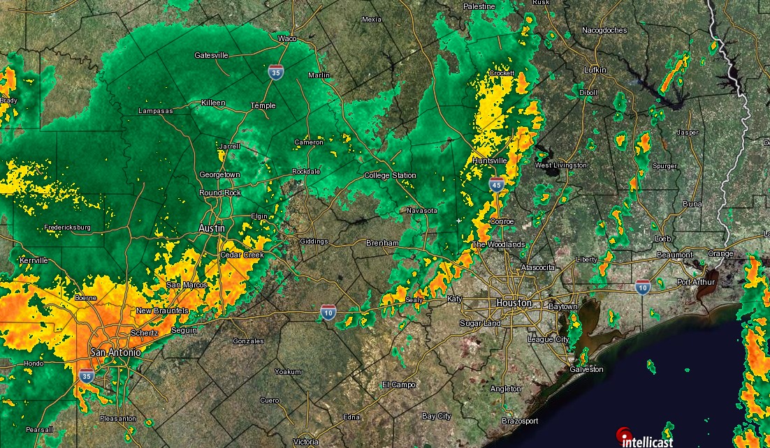
A large complex of storms dropped as much as six inches of rain over central Texas on Sunday night, and this morning the system is moving from the west into the Houston region. It has lost some of its potency, but still could produce 2 to 4 inches of rain over some parts of Houston today as it runs into the moist Gulf of Mexico air mass. Other areas should see less rain, but most of Houston should at least see some showers. Mostly cloudy skies should keep highs in the low 90s. A healthy chance of storms will remain during the overnight hours.
Tuesday
With low pressure (yet another advancing cold front that will stall over the area) and high moisture levels hanging around, I expect another day of widespread showers, with some thunderstorms producing heavy rainfall. For most people accumulations should be under 1 inch on Tuesday, but again there could be some localized street flooding issues under the heaviest storms. Highs around 90 degrees.

Wednesday, Thursday, and Friday
As the surface low pressure retreats back north, rain chances will diminish during the second half of the work week. We will probably fall back into a more summer-like pattern, with scattered afternoon showers and thunderstorms. For some areas this may mean some intense, albeit fairly brief storms. For most of Houston it probably won’t rain. Partly cloudy skies should allow highs to rise into the low to possibly mid-90s.
Saturday and Sunday
Our weather for this weekend will depend upon the strength of a building ridge of high pressure. Right now it doesn’t appear to get too strong over Houston, which would leave us open the chance of some scattered showers. Temperatures probably will be warm, with highs in the mid-90s. But at this point I don’t have a whole lot of confidence in the weekend forecast.
Tropics
You may have seen that Tropical Storm Franklin formed Sunday night in the Western Caribbean Sea. Forecast models are now in tight agreement that the storm will move across the Yucatan Peninsula and that high pressure pushes the storm due westward, into the Mexican coast for a final landfall.
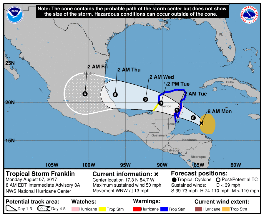
The storm should be compact enough such that Houston (and Texas) sees no significant effects from it. Beyond Franklin the Atlantic tropics are fairly quiet—always a good thing in August.
Posted Monday at 7am CT by Eric
Really hoping this ULD dives South into IAH. We’ve picked up 0.56″ so far. We could use a lot more. Thanks guys for keeping us updated!!
Gents – Do you have a sense about the timing for the heaviest rains? Is this an all day thing, or successive lines of storms? Thanks!
Sorry, not a whole lot of confidence in timing. Kind of an off-and-on thing all day with successive lines of storms.
I don’t think so.
Well with this mess, at first I though I overdid the “promise” to “bring back cooler weather from the Pac NW.”
But we had thunderstorms, and the coastal area where I was rarely gets them. There were no thunderstorms in the Olympia area between July 21 and 31, when I was there.
🙂 So I’ll continue to take credit for the un-August-like cooler temps, but the flash flooding must be due to someone who returned from monsoon season in Africa! 🙂 I’ve been back for over a week, so don’t blame me when it gets hot again.
So looking at the historical weather charts at https://weatherspark.com/y/9247/Average-Weather-in-Houston-Texas-United-States , it looks like today is, on-average, just about the worst day of the year in terms of heat and humidity.
Average high of 95F, humidity averaging 35% of the day in “miserable” range, 50% “oppressive”, 12% “muggy”.
I say this as a positive thing. From a seasonal average standpoint, the weather should only be getting better from here.
We have about four more weeks of guaranteed steamy summer weather, and then we can start to look for meaningful relief.
Why does KTRK have the rain chance up to 80% and NOAA’s forecast only has a 50% chance for Tuesday, Eric?
“Beyond Franklin the Atlantic tropics are fairly quiet—always a good thing in August.”
And let’s keep it that way! I believe the National Hurricane Center’s stats show that the middle weeks of Sept have the highest incidence of damaging tropical systems hitting the Gulf Coast. But Katrina was Aug 28-30.