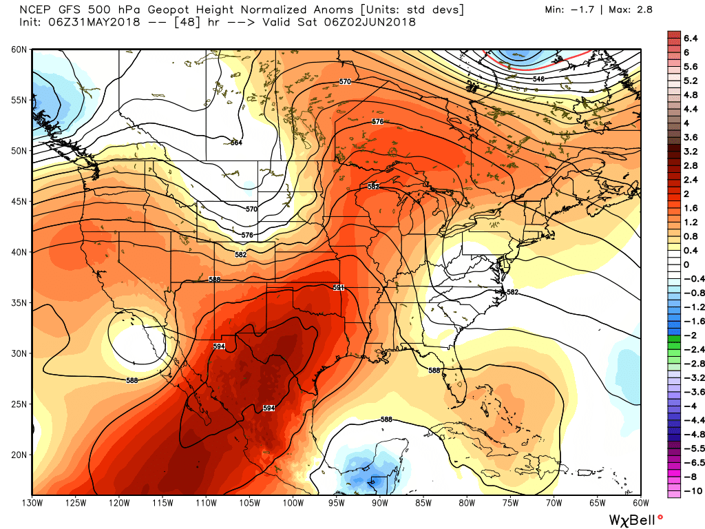
The heat will continue as high pressure remains more or less in control of Houston’s weather. Why? High pressure occurs when air above sinks downward—this increasing the pressure of the atmosphere at the surface. This descending air generally inhibits the formation of clouds, and very often prevents moist air at the surface from rising, and returning as precipitation. So hot, and sunny.
High pressure (deeper reds) will dominate our weather through Saturday. (Weather Bell)
Thursday, Friday, and Saturday
And this is just what we’re going to get for awhile—hot and mostly sunny, with highs in the mid-90s for the most part. Warm nights in the mid- to upper-70s. Not much more to say as high pressure dominates our weather.
The month of May is about to draw to a close, and it has been a warm one for Houston. Through Tuesday, the average temperature for the month at the city’s official weather station, Bush Intercontinental Airport, is 79.6 degrees Fahrenheit, which is 3.0 degrees above normal. (We’ve had just two days this month with below normal temperatures). It appears as though this May will end up as the third warmest May on record in Houston, ranking behind only 1996 and 2010. That may or may not be significant—the summer of 1996 did not end up being abnormally warm, but 2010 certainly did.
Wednesday and Thursday
Our July-in-May weather will continue to wrap up the month, with high pressure building over the region and keeping daytime highs in the low- to mid-90s. Some scattered afternoon clouds may help with temperatures just a wee bit, but it’s still going to be extremely warm out there so please take precautions.
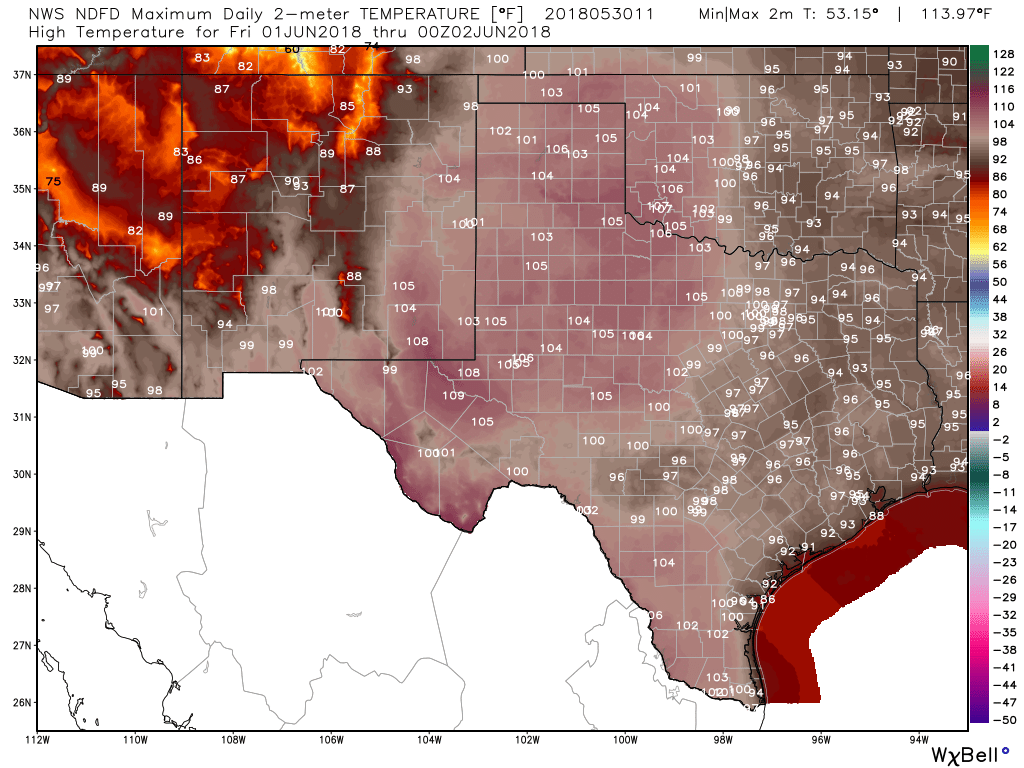
NDFD high temperature forecast for Friday. (Weather Bell)
Friday and Saturday
As high pressure dominates, the story across Texas will be heat. The National Weather Service gridded forecasts are absolutely brutal on Friday, with highs of up to 110 degrees in some parts of the state. This is deep summer weather for Texas to start the month of June—and typically summer doesn’t peak until late July or August.
Hurricane season officially begins later this week, but as we’ve seen with Subtropical Storm Alberto, Mother Nature doesn’t care overly much about arbitrary dates. Nevertheless, it is the time of year to begin thinking about the tropics, and so we’re going to help you get ready with some questions and answers.
Why does hurricane season occur now?
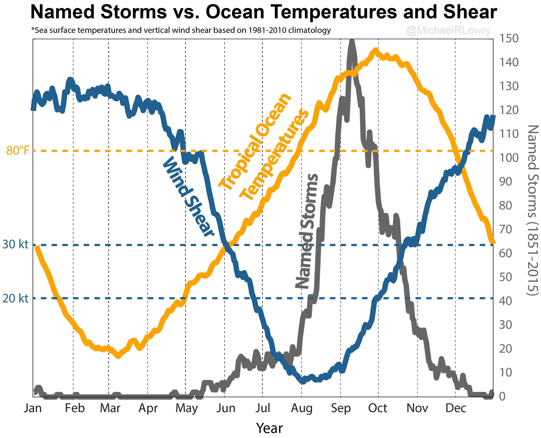
The easy answer is “warmer water,” and it is true that sea surface temperatures above 80 degrees Fahrenheit are generally needed for tropical storms to form, and strengthen into hurricanes. However, seas in the tropics are generally warmest in October, when hurricane season often begins to wind down. There is another factor, wind shear, that is critical. When winds are rough, and blowing as cross directions at different altitudes, storms simply cannot form. Typically, tropical storms will thrive only when wind shear values near the center are below 20 knots. The following graphic, from FEMA’s Michael Lowry, shows why the hurricane season lasts from June through November, but typically peaks during early September.
(Michael Lowry/FEMA)
Help! I’ve seen a really scary forecast on Facebook
Already this season we’ve seen some hyperbolic forecasts on Facebook. In March, a post forecasting doom and gloom for the 2018 Atlantic season went viral, and more recently a post showing a major hurricane hitting Texas in June got passed around. Such “social mediarology” plays on the fears of people, and therefore tends to get shared widely. If you’ll promise to not fall for these kinds of fear-mongering posts, we’ll make a pledge to you: If we believe there is a credible threat to Houston, we will report that immediately. And if we haven’t written about it, the post you’ve seen on Facebook is probably garbage.
Memorial Day weekend has come and gone, Houston’s basketball season has unfortunately ended, and the first named storm has already graced the tropics—I guess we must acknowledge that summer has really and truly come to Houston. This means two things for the upper Texas coast: high pressure, and when there’s not high pressure it means the region is open to tropical moisture. To that end, with the onset of hurricane season, we’ll have some additional content this week. Later today, in fact, I’ll answer some commonly asked questions about Houston and hurricanes. Later this week Matt will talk about how Hurricane Harvey changed the way local meteorologists were challenged and changed by the storm.
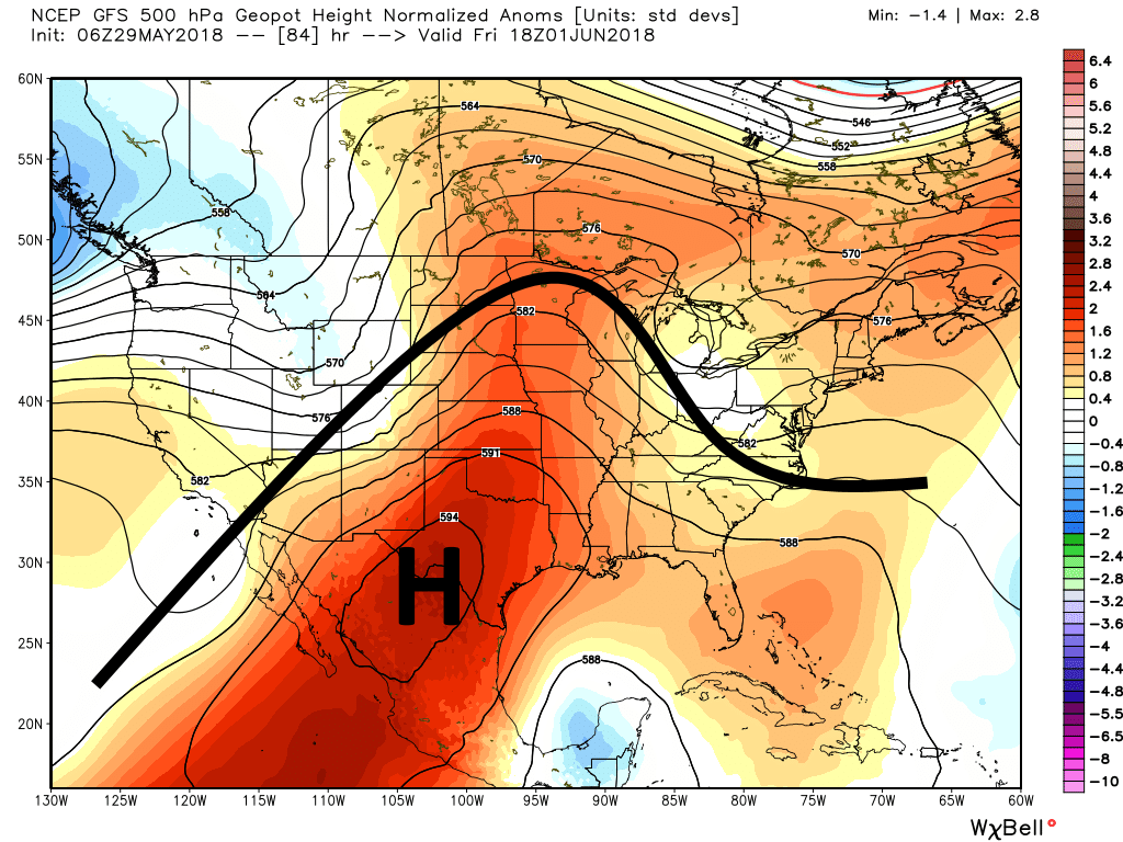
Texas is going to sit under a big, fat ridge of high pressure this week. (Weather Bell)
Tuesday
For now, high pressure ridging will remain dominant. There really is not a whole lot to say as we settle into a familiar pattern of warm, sunny days, with high temperatures in the low- to mid-90s, and warm nights in the mid- to upper-70s.