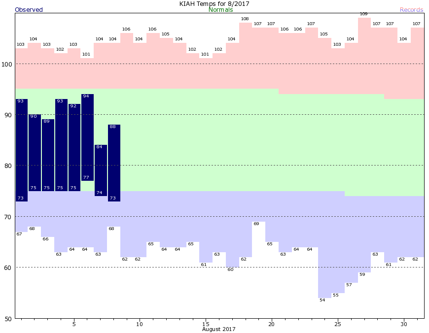
As expected the rains have moved out of the greater Houston region, and the heaviest storms are now over central Louisiana. Although a flood warning is in effect for Cypress Creek today in Harris County, only minor flooding is expected for portions of Sharp Road and Katy Hockley, which will may become inundated and possibly impassable later today or tonight.
The story is different to our east. Take a look at the total rainfall received in the Texas-Arkansas-Louisiana area during the last 48 hours. Note the very large area of 12 to 15 inches of rainfall in the Barney-colored purples.
Well, some heavy rain finally came overnight, with 1 to 4 inches generally falling across the Houston area. We were lucky. A region along the Texas-Louisiana border north of Beaumont received 6 to 10 inches overnight, and there are major flooding problems.
Here’s a look at the overnight rain totals in Houston.
According to the Harris County Flood Control District, here are a list of watersheds affected by the rains:
Little Cypress Creek:
Creek is overbanks at Becker Rd with minor flooding in progress. Subdivision on the south side of the creek west of Becker Rd may experience some flooding of the streets as water backs up into the underground system. Creek continues to rise slowly, but looks like it is close to crest.
Upper Spring Creek:
Creek is overbanks from the headwaters to below Hegar Rd. Field Store Rd and Hegar Rd have flooding over the roadways. The creek is continuing a very slow rise.
South Mayde Creek:
Creek is overbanks at Greenhouse Rd. Creek has crested and is starting to fall. Greenhouse Rd is passable.
Upper Cypress Creek:
Creek is nearing bankfull at Sharp and Katy Hockley and will likely exceed banks later this morning. Current RFC forecast brings the creek to near 158.5 ft tomorrow morning. Minor flooding is likely along the channel from the headwaters to upstream of US 290. Portions of Sharp Rd and Katy Hockley will likely become inundated and possibly impassable.
Little Mound Creek:
Creek is overbanks and continuing to rise and may be close to impacting Mathis Rd.
West Fork San Jacinto River:
River began a rapid rise overnight. It is forecast to crest at 51.3 feet Friday morning.
The National Weather Service has extended a flash flood watch for the greater Houston area through 6 a.m., and it does appear a fairly broad line of storms is moving in from the south.
These storms could provide heavy rain showers across parts of the Houston area, especially along the coast and to the east of Interstate 45, during the evening hours.
Houston so far today has missed out on heavy rain as the showers have developed mostly to our west and north. Here’s a look at rainfall totals, through 11 a.m. CT, for the last 24 hours.