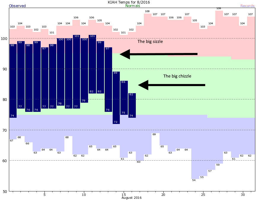
Through the first 12 days of this month Houston had an average high temperature of 99 degrees, including five consecutive days with highs of 100 degrees or above. Overnight lows were sticky, too. We all felt the sizzle. But as high pressure moved out, and clouds and rain moved in, daytime temperatures have plummeted. During the last three days Houston has enjoyed high temperatures averaging 85.5 degrees, and morning lows of 75 degrees.
Of course the counterpart to these delightfully “cool” temperatures for August has been the potential for flooding, and it’s not going away quite yet I’m afraid. Houston remains under a flash flood watch through at least 7pm Wednesday evening.
Today and Thursday
With that said the forecast isn’t particularly intimidating. While tropical moisture levels remain high, storms that do form have been moving along fairly quickly from south to north, meaning that even the stronger thunderstorms are only dropping 2 to 3 inches over hardest hit areas. While this may cause some localized street flooding, but so far we’ve not seen the kinds of sustained rains that can back up Houston’s bayou system.
While we can’t entirely rule that out today or Thursday, I’m feeling pretty confident that we’re going to avoid widespread flooding from this event. So for the next couple of days we can expect mostly cloudy days, intermittent moderate to heavy showers, and high temperatures in the mid- to upper-80s.
Friday through Monday
As we’ve been suggesting for several days, moisture levels should fall back a little bit by the end of the work week, meaning we’re going to see fewer widespread showers, and more scattered storms. The most likely time for rain will be during the afternoon hours, and I’m not expecting any kind of a washout.
Fewer showers should also mean we’re going to see more sunshine, and accordingly I’d expect high temperatures to rebound into the upper 80s to about 90 degrees this weekend, with correspondingly high humidity.
Looking further ahead, I don’t expect high temperatures to get back into the mid, or especially upper 90s later next week. This week’s rains should help limit highs a bit for awhile.
Tropics
Tropical Depression Six has formed in the deep Atlantic, but this system looks to remain well out to sea and not threaten any landmasses over its lifetime. As we get into the peak of hurricane season, expect more storms to follow this one over the next few days and weeks.
Posted at 7:20am CT on Wednesday by Eric
An actual coolness in he breeze as we left the Juice Box Ballpark. After an Astros loss and the price of beer, the coolness was a real treat.
…”expect more storms to follow this one over the next few days and weeks.” Eric, I wish “follow” meant same path as TD 6 but that would be askin’ for too much I guess…in the meantime thanks for introducing “chizzle” into the weather terms…we’ll take more of that!
After 7:00, are we going to be able to say good-bye to that pesky Flash Flood Warning for a while ?
It was my understanding that these rains would slowly taper off the closer we got to Friday. Yet, it’s been raining every day and the rain chances stay high, with very little sign of change. Why?