After two consecutive 100-degree days are you ready for a bit of a reprieve? I thought so. And fortunately, cooler and especially wetter weather is at hand. Change is coming.
Today and Tuesday
Much of the area is likely to see rain showers today, Tuesday—or both. We’re seeing increased atmospheric moisture levels in combination with some lower pressure that should lead to much-needed rain. The most likely time for showers is after about 1pm through the late afternoon hours.
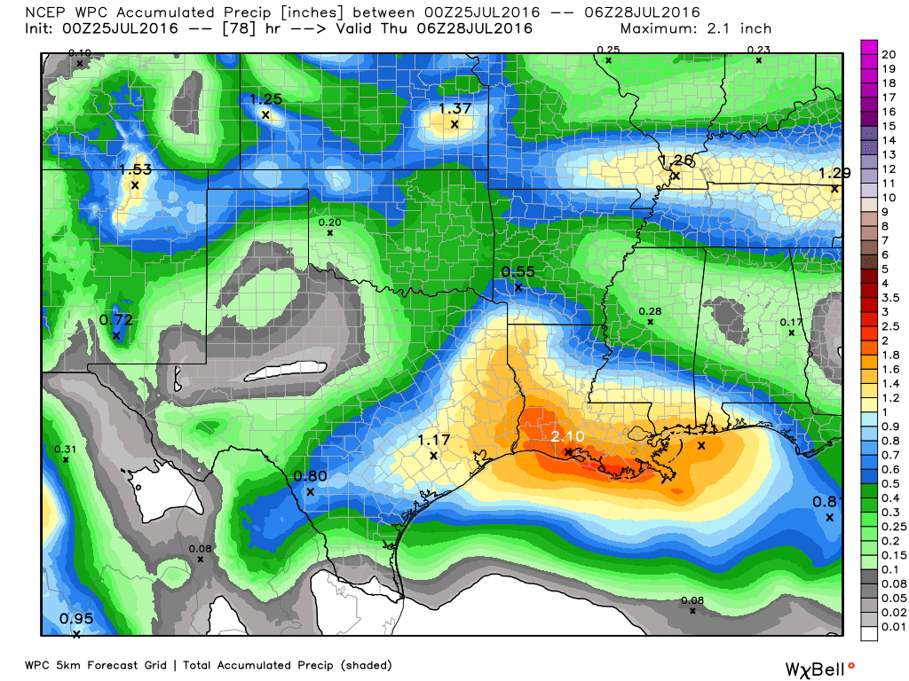
NOAA rain accumulation forecast for now through Wednesday. (Weather Bell)
Although with these moisture levels we can’t rule out some locally heavy rainfall, with rates of 2-3 inches per hour, conditions aren’t going to be ideal for these kinds of deluges. As a guess I’d say most of the area will receive about 1 inch of rain, plus or minus, over the next two days. High temperatures, accordingly, should only rise into the low 90s.
I’m back—and I bring some good news. First of all I want to thank Matt for holding down the fort while I grabbed some vacation. It was nice to unplug for awhile. But now I’ve returned, and I’ve come with much more promising rain chances and relief from the heat.
Yes, some areas of Houston received a very good dousing last week, particularly central Houston. But most of the area has seen 1.0 inch of rain or less during the month of July, at a time when temperatures have consistently been in the mid- to upper-90s. (This leads to a very high pan evaporation rate, meaning soils dry out very quickly). So some rain is welcome, both for our trees and green spaces, but also to moderate daytime temperatures. And some is coming.
This weekend
The sprawling high pressure system that’s been anchored over the south-central United States, including much of Texas, is moving off to the west. But there’s likely going to be a modest capping inversion today and Sunday, and moisture levels aren’t the highest, so I think we’re only going to see some scattered rain showers this weekend, primarily during the afternoon hours. Rain chances are best to the east of Interstate 45. Lacking widespread rain, most areas will likely see highs in the mid-90s.
Monday and Tuesday
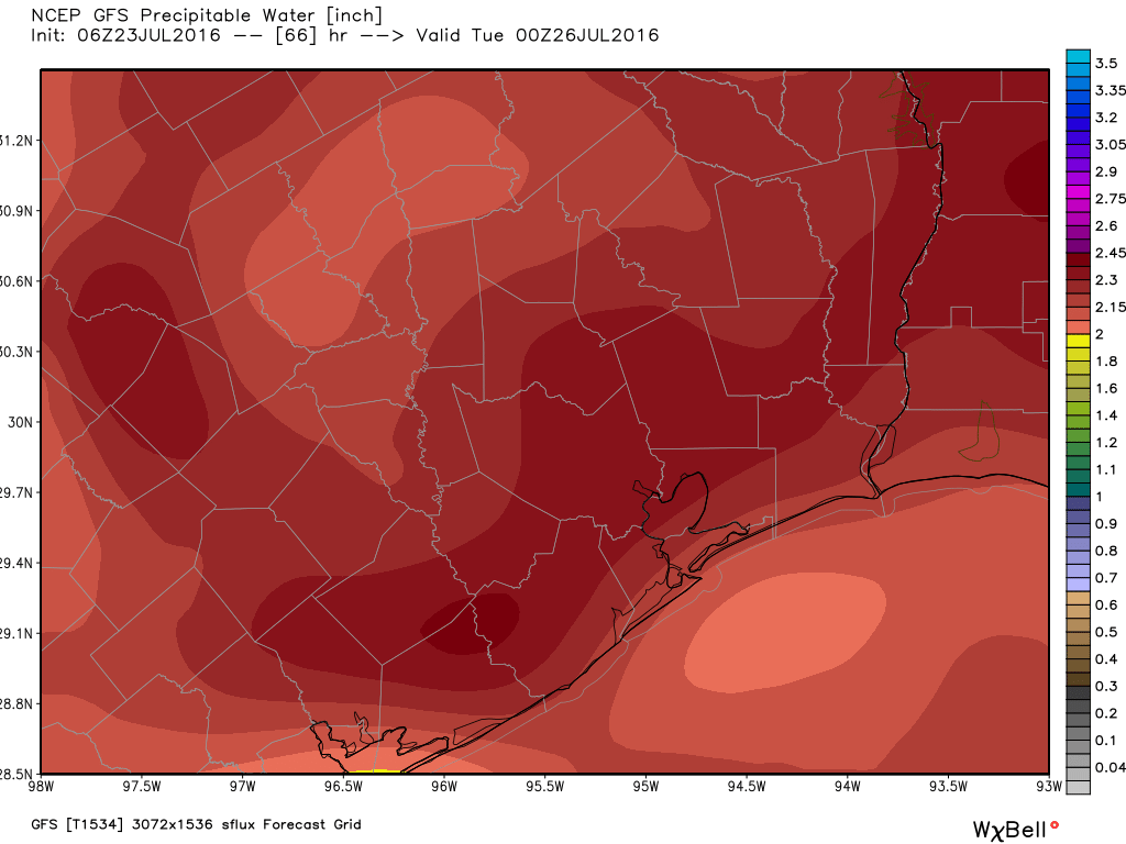
By Monday we’re likely to see atmospheric moisture levels climb above 2.3 inches of precipitable water—which is very good for rain chances.
Precipitable water levels are likely to surge on Monday and Monday evening in Houston. (Weather Bell)
This, along with some low pressure moving into the area from the Gulf of Mexico should be enough to bring some fairly widespread rain showers into the metro area. I think much of Houston can probably hope for 0.5 to 1.0 inch of rain, and there’s the potential for heavier, more localized rain showers. Clouds and intermittent rain should hold high temperatures for both of these days to the low 90s, if not 90 degrees.
Wednesday and beyond
Pressures appear to rise beginning Wednesday, but it doesn’t look as though we’re going to see dominant high pressure. This should hopefully keep daytime temperatures in the low 90s, with at least some scattered rain showers most days.
One of my favorite Led Zeppelin songs is titled The Song Remains the Same, and that’s an apt tune for our weather. Houston’s weather forecast remains the same. Which is to say we’re going to be hot, with slight rain chances, for days and days and days to come.
Today through Monday
High pressure is off to the west, but that doesn’t mean conditions are overly favorable for rainfall, with only modestly high levels of moisture in the atmosphere. One global model (the European) suggests most of the area will get 0.25 to 0.50 inch of rain between now and Monday, cumulatively, whereas the GFS model sees less than 0.10. The European model tends to be correct more often and has been consistent with its forecast, so that’s a good thing. But I wouldn’t describe my forecast for some rain during the next five days as high confidence.
In any case, when it doesn’t rain temperatures will remain very hot, with highs in the mid- to upper-90s and lows in the upper 70s to 80 degrees.
Tuesday and beyond
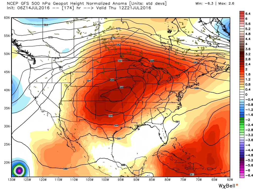
As we’ve been suggesting this week, strong high pressure will build over the central United States next week.
That’s a big ridge of high pressure just to the north of Houston next week. (Weather Bell)
The heat continues, unabated. Through Tuesday the region’s average temperature is 88.2 degrees, which keeps Houston on track for the warmest July in the city’s history (87.5 degrees in 1980). We might see a bit of relief this weekend, but then we go back into the fryer.
Today through Friday
Our heat should persist at these near record levels during the rest of the work week, with highs in the mid- to upper-90s. However I believe overnight lows may drop a degree or two back into the upper 70s for most areas. Also, as we are not under a dominating ridge of high pressure some afternoon showers are possible, although I don’t think coverage will be greater than 10 to 20 percent of the region—and that may be optimistic.
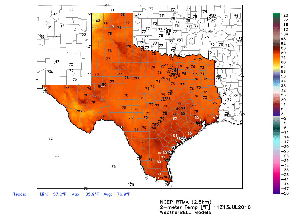
You’d have to go all the way to Perico, in the Panhandle, to find some relief from hot temperatures in Texas this morning. (Weather Bell)