In brief: One more chance at scattered storms exists today in Houston, followed by a quiet, hot weekend. We’ll get some classic early summer fare before our next chance at storms and a possible cool front later next week.
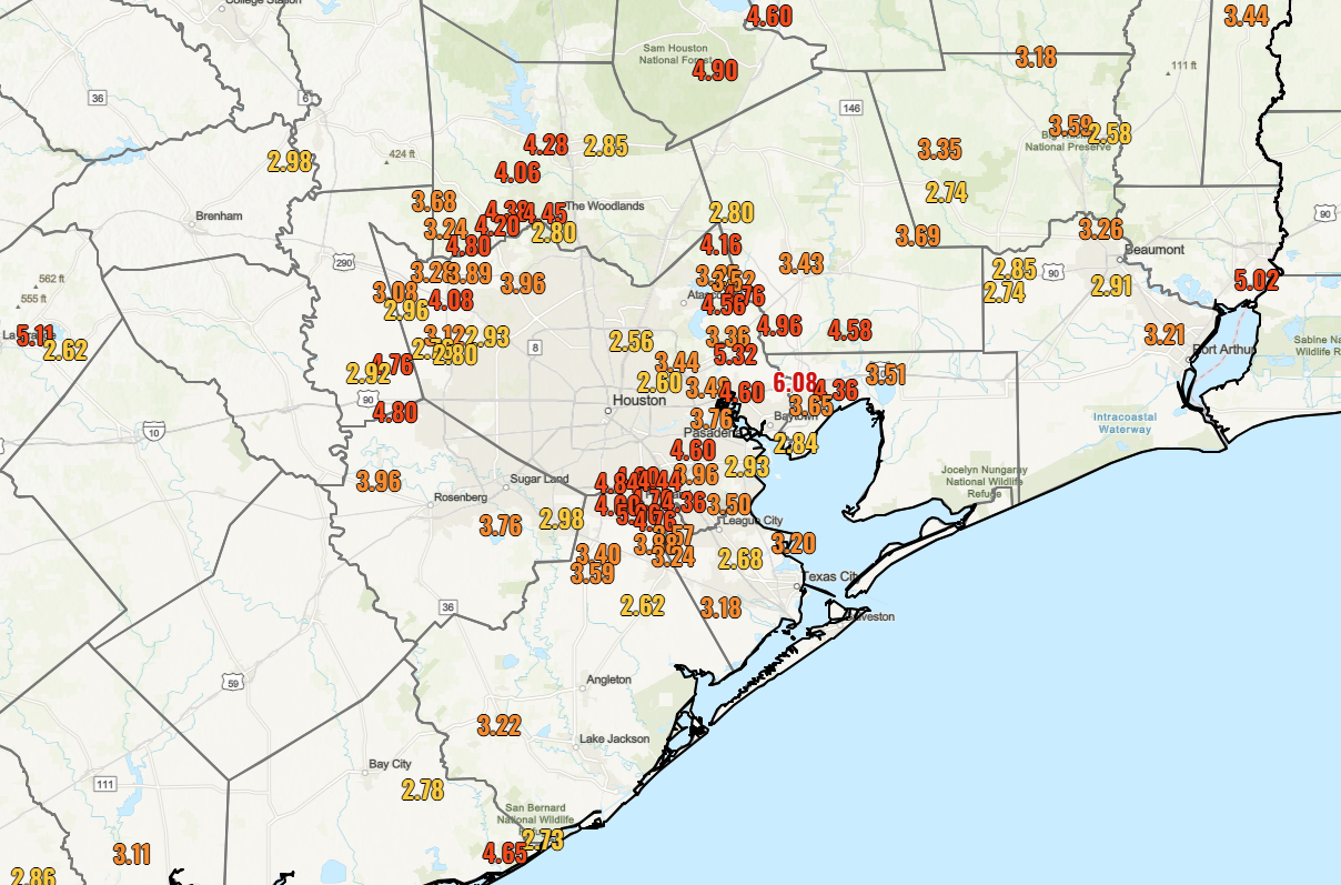
Most parts of the Houston area have seen a pretty good week in the rainfall department. Everyone has seen about a half inch to an inch of rain, with a couple exceptions near Wharton, College Station, and the East End of Galveston onto the Bolivar Peninsula.
Locations that saw at least 2.5 inches of rain this week. (NOAA)
Three areas really stood out this week. The area just north of Baytown and west of Mont Belvieu saw over 6 inches of rain. Pearland also got close to 6 inches of rainfall in spots. It’s likely that Liverpool in Brazoria County may have seen even higher totals this week. The area just south of Lake Livingston also saw nearly 6 inches of rain. So, your mileage definitely varies, but all in all a beneficial week of rainfall here.
Today
We have one “kinda sorta” chance of rain today. This should not be anything organized; just heating of the day random pop-up downpours. Most places will probably be dry today, but those that see a downpour could snag a quick quarter to half inch of additional rainfall or even a bit more along with some thunder and lightning. Otherwise, expect decreasing clouds and highs well into the 80s. All good for the Dash match tonight.
Saturday and Sunday
Both days may start off with clouds but transition to sunshine. Expect warm, humid conditions all weekend. Highs will be in the mid to upper-80s, with lows around 70 degrees. MS150 riders will get the tailwind this weekend at least, out of the southeast 5 to 15 mph or so. An isolated downpour can’t be entirely ruled out for the weekend, especially on Sunday, but it seems highly unlikely. Conditions look all good for the SaberCats or Dynamo matches Saturday.
Monday and Tuesday
I would expect more of the same for the start of next week: Clouds to sun, highs in the upper-80s and lows in the low to mid-70s. We do have a chance at 90 degrees on Tuesday.
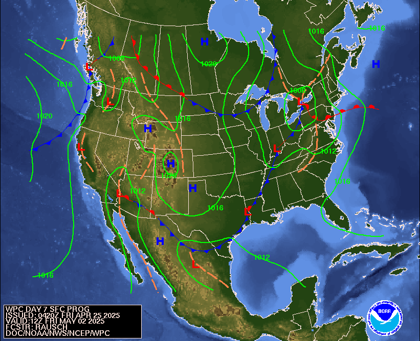
Surface map forecast for next Friday morning showing a chance that a cold front pushes through Houston. We’ll see if that actually occurs. (NOAA)
Wednesday and onward
Conditions get more unsettled Wednesday and Thursday with scattered showers and thunderstorms possible. We’ll see about risks for heavy rain or any severe weather; it’s too soon to say at the moment, but it would seem we will get a couple rounds of storms in the area. We could see a push of drier air follow a cool front on Thursday, which could set up a nice end of the week. Fingers crossed.
In brief: The first part of the weekend looks good, but we do expect Houston to see thunderstorms on Easter Sunday. Some of those storms could be strong, and that will be followed by more storm chances next week. Springtime is in force.
Today & Saturday
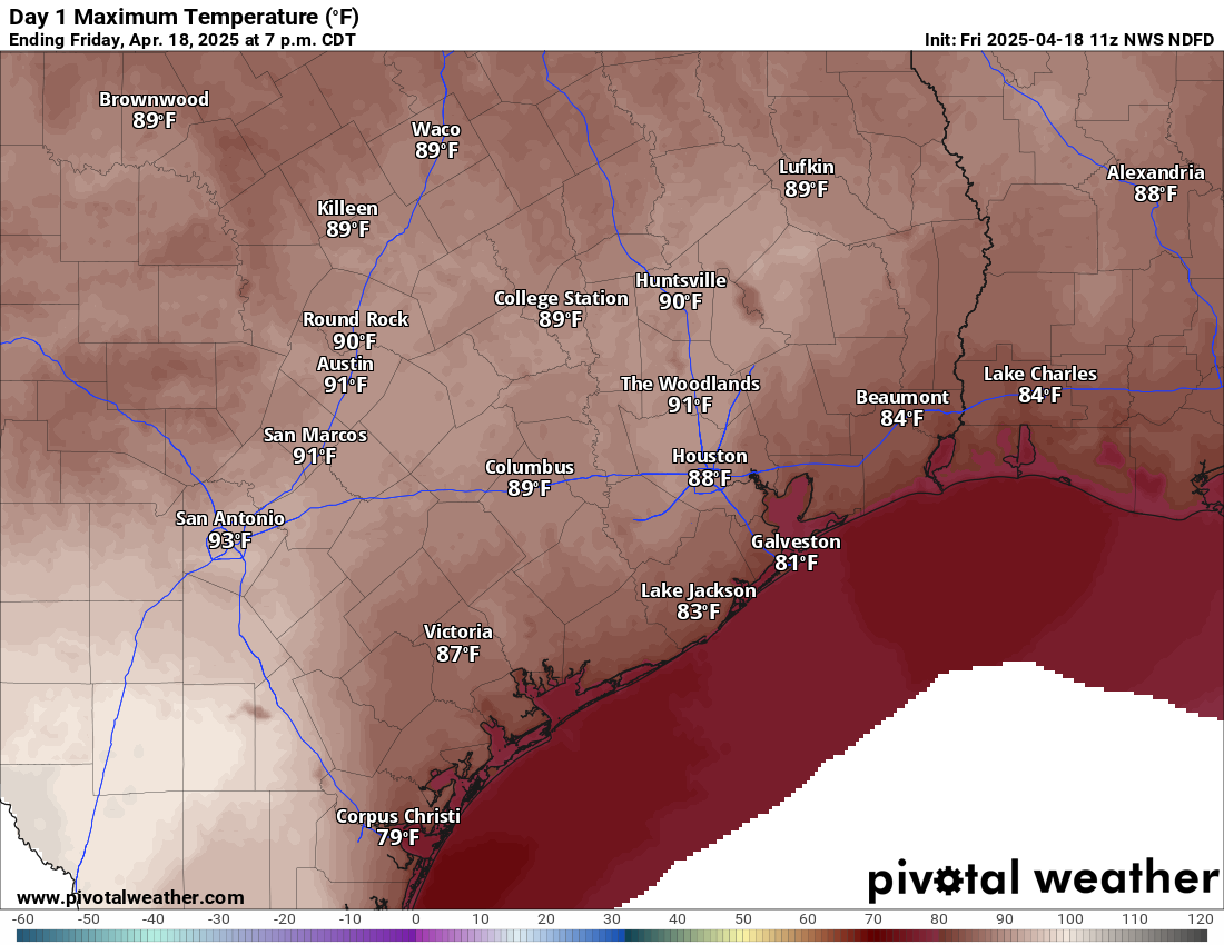
If you like hot weather, you’re in luck! There’s a pretty good chance we’ll hit or exceed 90 degrees today. It will also be quite breezy with south winds gusting up to 30 mph or so. Other than that, expect a mix of clouds and sun.
Many parts of the area will hit the upper-80s to low-90s today. (Pivotal Weather)
Saturday will be a bit cloudier. We’ll have a very mild morning, with lows probably not much below 75 degrees, close to a record for warmest April 19th morning. The day should again be breezy, mostly cloudy, and not quite as hot (but plenty humid). Highs should get into the mid or upper-80s. Shower chances look minimal, but I wouldn’t be shocked if the sky squeezed out a few raindrops here or there. Better shower chances will exist back toward Hill Country.
Easter Sunday
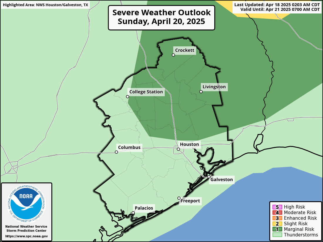
Sunday morning will be at least a little interesting. There should be a line or complex of thunderstorms near I-35 and the Austin area around sunrise. As those cross I-35 and move toward southeast Texas, they *should* begin to fall apart. Thus, the morning should be mostly cloudy with a couple showers here or there. As the boundary from that decaying line of storms hits Houston in the afternoon, we should see new thunderstorms blossom across the area. Some of these storms could be on the stronger side, and the SPC has us partially in a marginal (1/5) risk for severe weather on Sunday. This could yet change some between now and Sunday.
A marginal risk (1/5) for severe weather is in place on Sunday for afternoon and evening thunderstorms, with gusty winds or hail a possibility. (NOAA SPC)
In addition to the potential for some strong to severe storms, atmospheric moisture levels will be more typical of mid-summer, so we could see some torrential downpours and localized street flooding crop up.
Eric and I will monitor this through tomorrow and have any updates for you on Sunday morning.
Next week
The cold front that will be responsible for the storms on Sunday is likely to stall out or wash out overhead. I would not be shocked to see the focus of thunderstorm activity on Monday to stay mostly east of Houston, closer to Lake Charles and Beaumont. But by Tuesday, that may swing back toward us, leading to scattered storms for Tuesday and possibly Wednesday or Thursday. This is the time of year where we can see afternoon storms blow up in portions of north or central Texas, organize into a cluster, and make their way toward us as complexes of storms called mesoscale convective systems (or MCS’s). I would not be at all shocked to see us have to wrangle that next week at least once. Bottom line: It looks unsettled.
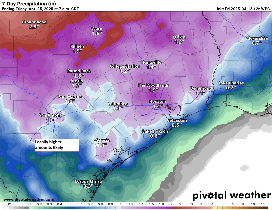
Rain totals of an inch or more inland and at least a half-inch at the coast are likely through next week. There will be higher amounts peppered in as well. (Pivotal Weather)
It’s a bit early to get into potential specifics, but it does appear that next week will be active. The clouds and shower chances will hold daytime temperatures lower next week (more like low 80s), with warm nighttimes in the upper-60s to low-70s.
To be honest, there is very little to discuss with respect to Houston’s weather forecast. We expect sunshine, warm and dry weather, and some ground ozone/air quality issues in the mornings and evenings over the next few days. Highs will be in the 80s with lows in the 50s and 60s. Beginning around Sunday, we’ll add some more humidity to the mix and slightly hotter weather with highs near 90 degrees by Monday and lows in the 60s. Overall, it looks great, albeit a little hotter than usual for April.
Our next meaningful rain chance likely does not come until the middle of next week, if then. More to come.
Nothing about this forecast on the surface is especially notable or alarming or fascinating. It’s simply a slightly above average forecast.
But what is somewhat notable about their forecast is some of the under the hood items they address. First, we are likely to be coming out of a La Niña event, something we discussed last back in February. But as the CSU team notes, we don’t know for sure if we’re headed for El Niño or ENSO neutral (La Nada) conditions. ENSO neutral summers combined with warm water temperatures “typically provides a more conducive dynamic and thermodynamic environment for hurricane formation and intensification.” In other words, hurricanes like those background conditions.
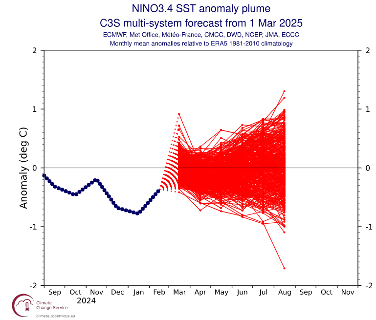
We do not yet have a “plume” from the C3S suite for April, but the March plume skewed slightly toward El Niño development.
Multi-system ensemble of various forecast models predicting a trend toward positive sea-surface temperature anomalies this summer, possibly giving a slight edge to a developing El Niño event. (Copernicus)
If we get to El Niño conditions by late summer or fall, that does not guarantee that conditions will shift to become more hostile to hurricane development. But that may take the edge off a bit. However, if we “hang” near the neutral line or even in weak La Niña territory, any hostile conditions may be apt to stay away, ensuring a busier season than usual.
In addition to the forecast for named storms and such, the CSU team also does try to convert that seasonal outlook to a prediction of U.S. landfall risk. Indeed, with a more active season expected, the odds of a U.S. landfall are also higher. They have a 51 percent chance of a major hurricane landfall on the U.S. coast, compared to a historical average of 43 percent. The odds on the East Coast are 26 percent, compared to 21 percent typically. And in the Gulf, the landfall odds between the Florida Panhandle and Brownsville are 33 percent versus a 27 percent average.
According to the CSU team, all model guidance is pointing to an above-normal season. Water temperatures remain well above long-term averages across the Atlantic. As we noted earlier this year, however, this is not last year’s Atlantic sea-surface temperature profile. But it’s still quite warm.
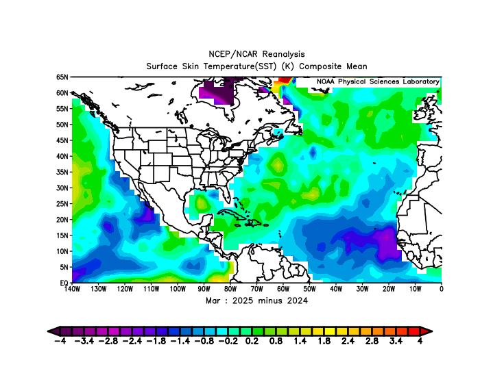
March 2025 minus March 2024 sea-surface temperatures, showing year over year warming in the Caribbean, Gulf, and mid-latitudes, but not in the tropical Atlantic. (NOAA PSL)
From the map above, you’ll notice that the eastern Atlantic has cooled markedly since last year, however the Gulf, Caribbean, and northern Atlantic Ocean are all warmer. The fire that was burning all last summer in the eastern Atlantic is still smoldering, but it has been somewhat extinguished. The Gulf and Caribbean are another matter. The Gulf is warmer than 2024 by a good bit but still lags 2023. While the Caribbean was warmer than 2024 in March, it has since cooled some in April, taking it back under 2024 levels. Water temperature conditions can change quickly, but the bottom line is that the Atlantic, with the exception of the eastern basin are in the upper echelon of warm years at this point. The warmer overall waters in March in the eastern North Atlantic (north of the tropics), along with the warm Caribbean do correlate to active hurricane seasons.
The bottom line is that the underlying data support the idea of an active hurricane season — but not to the levels feared last year. But there aren’t very many red flags at this time arguing against that outcome. At least last year, we had the expectation of a developing La Niña to help grease the wheels a bit, and a slow development could have slowed the hurricane season a bit. This year? There’s no real glaring red flag that says the season will bust. But hurricane seasons always have surprises. Hopefully this year’s involves calm.
In brief: Other than some periods of poor air quality, the forecast for Houston is about as perfect for springtime as it gets with sunshine and low humidity through the weekend.
Today through Sunday
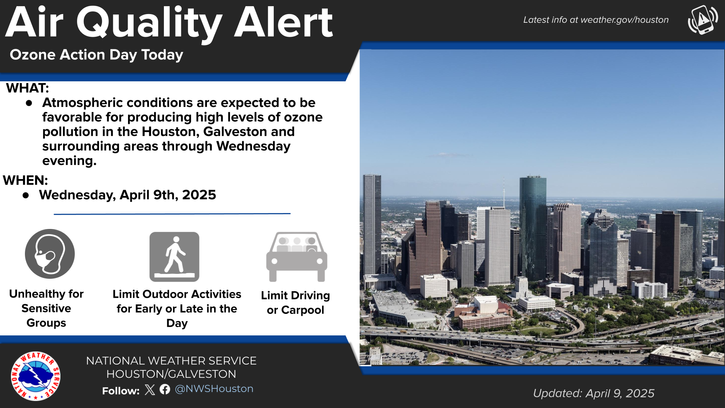
This is really going to extend an incredible stretch of sunny weather here in Houston. Very few clouds are expected over the next 5 days, with sunshine each day. You will see and hear about air quality advisories. The plentiful sunshine tends to interact with pollutants from cars and petrochemical facilities to produce ground ozone. You can read more about this here, but suffice to say, there will be periods of unhealthy air quality in the morning or evening, especially today, tomorrow, and Friday.
(NWS Houston)
Temperatures will flop around a bit. We’ll do low 80s today, mid-80s tomorrow and Friday, low to mid-80s on Saturday, and then mid to upper-80s on Sunday. Morning lows will be in the 50s or 60s. Overall, this will also be a fairly pleasant, dry air mass. Humidity will increase some this weekend but not to levels that would be deemed uncomfortable.
Next week
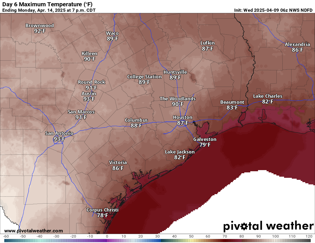
Even next week the pattern doesn’t change a whole heck of a lot for Southeast Texas. We should see more humidity, a little bit more in the way of cloud cover, and eventually some additional storm chances. Those probably don’t become really notable until later in the week. Temperatures should start to increase some and push 90 degrees by Monday or Tuesday.
Temperatures could begin to push 90 degrees by early next week. (Pivotal Weather)
Bottom line: Enjoy this week’s stretch because you never know how many more like this we’ll get before summer sets in.