In brief: Morning rain has thus far been manageable, but repeated rounds of thunderstorms along and on either side of I-10 will likely cause ponding and street flooding in spots this morning and afternoon. Flood Watches remain in effect through evening.
Happening now
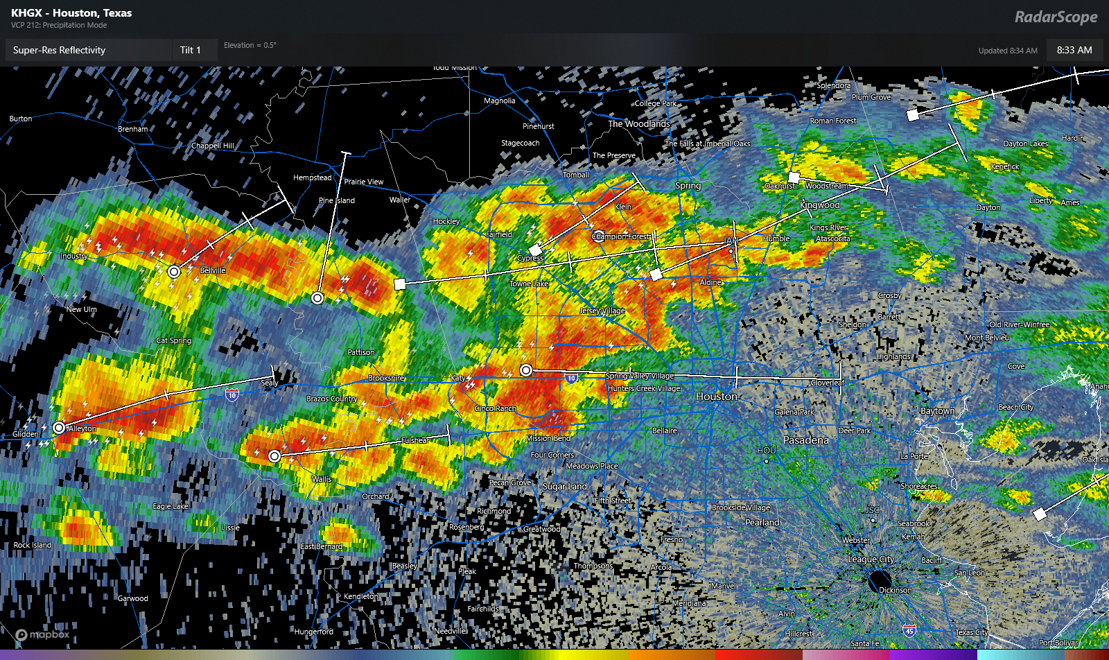
One round of heavy rain and storms has exited to our east. Rain totals from that round were manageable in the Houston area and most points north to Conroe. A couple flash flood warnings were needed north of Lake Livingston and back into Huntsville, where totals approached two inches. Now, we’re seeing a west-east line of storms from northern & central Harris County back past Columbus.
Rest of today
This line of storms will likely “train” west to east through the morning and early afternoon. This means repeated rounds of storms basically within 20 miles of either side of I-10. For now, there are enough gaps in between downpours to keep things mostly just annoying and not troublesome. If that continues like that the rest of today, we’ll be fine; yes there will be roadway ponding or localized street flooding but probably nothing much worse.

Eric and I have been wary about things this week because, frankly, most model guidance has struggled. But in general, things seem to be doing what was expected. So, thunderstorms this morning on both sides of I-10. Look for these to continue into early afternoon. Some scattered activity may pop up north of Harris County this afternoon, and we’ll watch for localized downpours up that way. The NWS Flood Watch continues through evening, and our Stage 2 flood alert will continue with that as well. If, for some reason this band of storms shifts farther to the north, it will not take a lot to begin flash flooding. And if for some reason, the rains over Houston remain heavy with fewer breaks, we could see more widespread street flooding. So that’s why we’ll maintain that Stage 2.
Editor’s Note: The National Weather Service Weather Prediction Center issued a discussion while I was editing this post, suggesting that heavier rain over the Houston area was likely through afternoon and could lead to more widespread street flooding. We’ll continue to watch this through the day.
Totals, as you can see from above should be generally 1 to 2 inches, with isolated higher amounts possible. Lower amounts toward the coast and perhaps to the north. Obviously, it’s been pretty rough this week in terms of forecasts and impacts, so continue to monitor the situation, and we’ll post later if anything seriously changes.
Conditions should improve this evening.
Monday and beyond
We finally begin to unwind this disrespectful weather pattern. Temperatures will begin to heat up, and we still expect low to mid-90s into midweek. Rain chances won’t be zero, but they’ll be much lower than they’ve been in recent days.
Even though the rain will quiet down, river flooding will continue this week. One river we have not discussed much is the Brazos. Things have been fine there, but the river is likely to continue rising all week and may even approach moderate flood levels by late in the week.
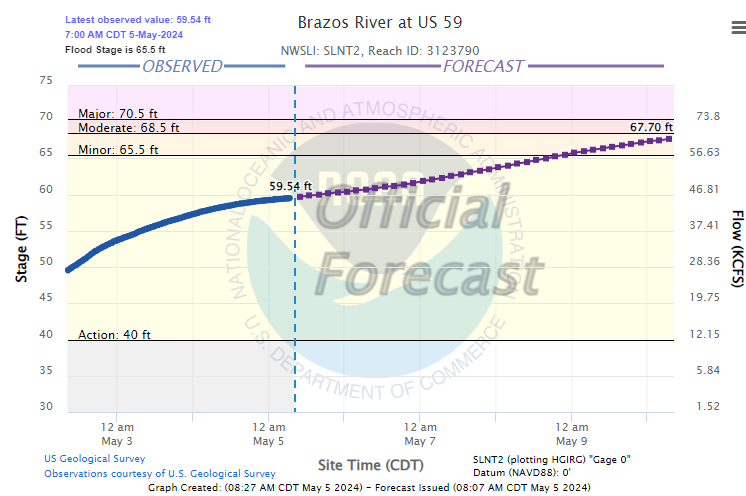
Beyond Friday, it’s a bit uncertain still, but assuming the river hits 68 feet or so, we’ll begin to see the flood plain get inundated, requiring the relocation of cattle. We’ll monitor this in the coming days; thankfully there’s time to prepare.

In the bright side we’re not entering summer in a drought and still have not had a 90 degree day…
Ahhh this is the Houston I know and bregudgingly love
Yes, this is the way I remember Houston being when I first came here in 1958.
My impression then was that it seemed to rain all the time.
Much better reporting, more civilized, less hysterical the space city we’ve all known and loved, no hype weather.