In brief: A major winter storm continues to look likely for the Houston area Monday night and Tuesday, with the potential for heavy snow and sleet in parts of the region. Minor ice may occur near the coast, along with windy conditions. Travel will become difficult to impossible Tuesday morning and remain that way through at least Wednesday morning across most of the area. A significant, damaging freeze is likely Wednesday morning as well. We do warm up Thursday.
Current cold
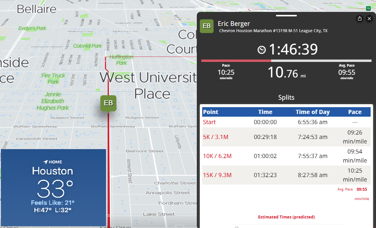
If you’ve stepped outside, or like Eric, started running the Chevron Houston Marathon, you know it’s, um, cold.
Speaking of which, let’s check on Eric as of 8:40 am! Good luck to Eric the rest of the way!
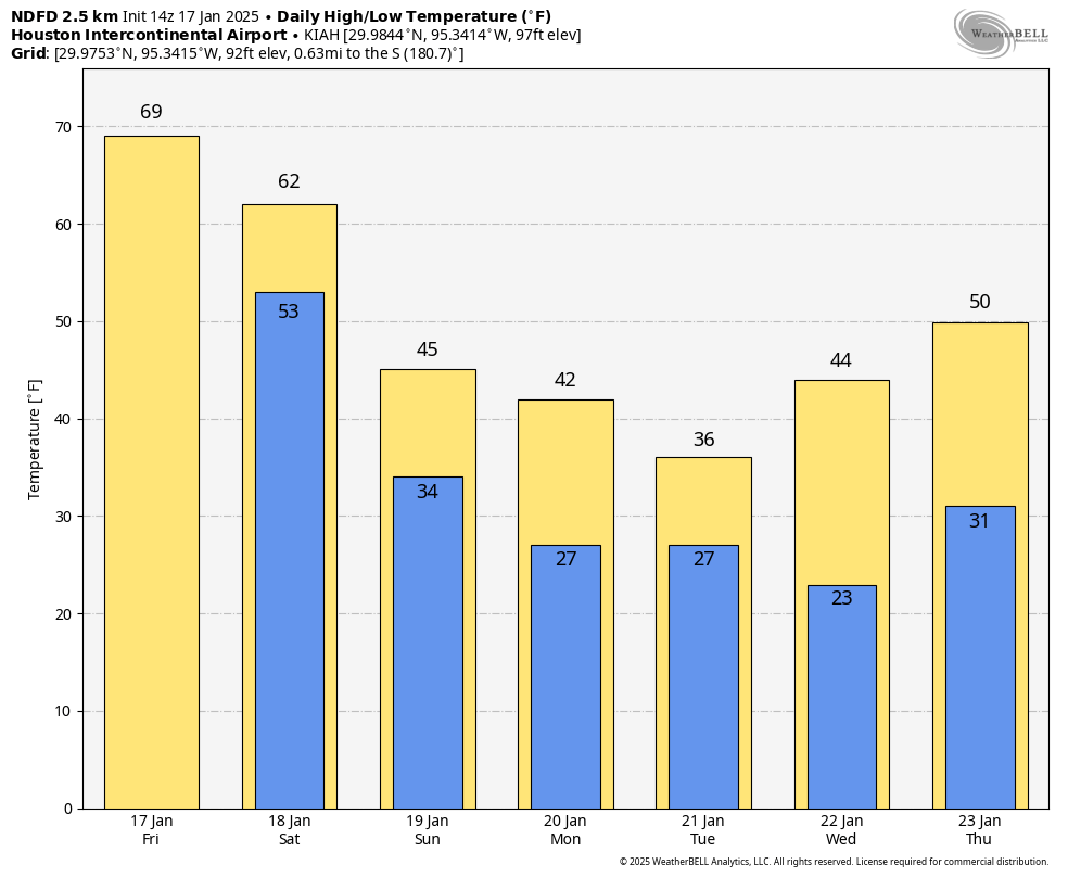
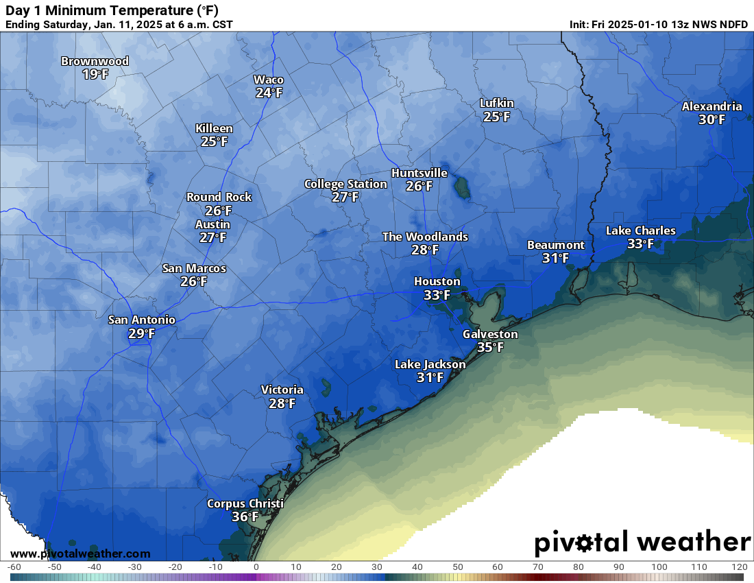
Temperatures will recover some today, getting up into the low or mid-40s. Another cold night is expected tonight, with lows in the 20s across most of the area away from the coast. Expect a hard freeze for many outlying areas and some areas in the city too.
Remember the basic preparations you should be taking.
- PLANTS. Protect tropical vegetation. Please note, with temperatures dropping this low, some vegetation will probably die regardless.
- PIPES. Protect any exposed outdoor pipes. Pipes in attics and along exterior walls of structures could freeze at these levels.
- SPRINKLERS. Sprinkler systems should be shut off and properly drained.
- ANIMALS. Prepare proper shelter and warmth for animals and livestock and make sure water sources are not frozen.
And also remember to check on people that may not have adequate insulation or access to heating.
Monday
Most of tomorrow should be fine. We will see increasing clouds that may hold temperatures back a bit. Highs should be in the upper-30s. Precipitation begins sometime either Monday afternoon or evening. With temperatures comfortably above freezing, whatever falls initially may be a light rain. Resist the urge to call bust.
Sidebar: The air mass over us will be quite dry. This is important. As the rain begins falling on Monday afternoon and evening, it may fall as virga (rain that does not reach the ground). But as it evaporates on the way down, it will cool the entirety of the atmosphere from a few thousand feet up to the ground. This is essentially priming us for snow and sleet. So initially, it may fall as rain, but that will change Monday night.
The best advice we initially can offer: Be where you need to be by early Monday evening and prepare to be stuck there through at least Wednesday morning.
Monday night and Tuesday morning winter storm
As the precip increases in coverage and intensity and temperatures drop, we will see a changeover from rain to a mix of sleet and snow. I have to be honest: Much of the model data seems to be favoring a gradual change from sleet to mostly snow, especially along and north of I-10. South of there, it should still be a mix of sleet and snow, with potentially a little freezing rain near the coast or Matagorda Bay area.
A couple notes about how things will unfold.
- This storm has been strongly signaling what we call mesoscale banding or the potential for a deformation zone. In plain language? There will be widespread snow and sleet, but embedded within that will be a couple corridors of heavy snow. Those bands can see quick, heavy accumulation and snow rates of 1 to 2 inches per hour, along with the potential for thundersnow.
- That banding will also lead to a disparity in snow totals. You could, in theory, have an area that sees 2 to 3 inches and literally down the road an area that gets 6 or 7 inches.
- Sleet is the biggest risk to all this. If we end up with significant sleet and less snow, accumulations will be much lower — but travel will be just as bad. Models are trending toward more snow over sleet for much of the region, but admittedly, this is not an area where models handle things super wonderfully.
- Wind will howl on Tuesday morning, especially on Galveston Island, where gusts could exceed 40 to 45 mph. Inland gusts will be to 20 to 30 mph. Coupled with areas of heavy snow, this will create extremely poor visibility and potentially some blowing and drifting of snow. Yes, that’s an actual sentence I just typed for Southeast Texas.
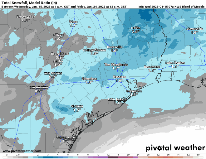
When all is said and done, how much snow will you get in your backyard? The official NWS forecast is shown below.
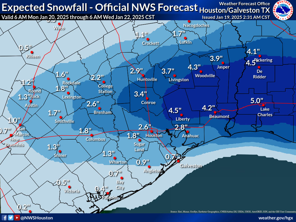
I will say that the risk is probably asymmetrically skewed to the higher side here. In other words, there is a chance of more snow than shown, but again it will depend on sleet and exactly where those “mesoscale bands” setup. Max totals could be, could be as high as 6 to 8 inches. But those will likely be the exception, not the rule.
How about ice? Well, the official NWS forecast is one that isn’t overly bullish on ice, which is good news. Ice is where you can start to have more meaningful issues with infrastructure issues (trees, power lines, etc.). Ice of this amount would make conditions a little extra slippery but be unlikely to cause damage.
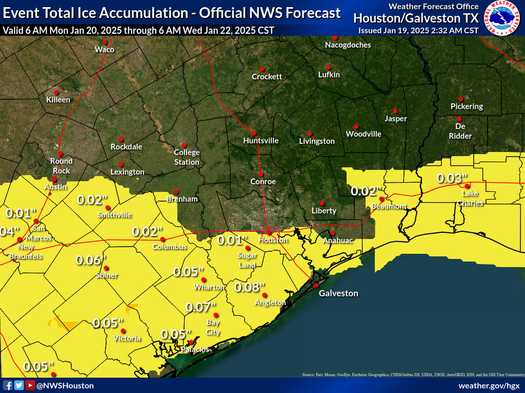
The highest ice totals are likely to be south of I-10 and in the Victoria Crossroads back toward south of San Antonio.
Travel concerns
There’s no real good way to get around this: We are inherently unprepared for a major snowstorm because, well, it rarely ever happens. Thus, you can expect that travel will be difficult to perhaps impossible on Tuesday, probably Wednesday morning, and maybe even Wednesday afternoon. We really cannot underscore this enough: Barring a dramatic forecast change, tou will probably not be able to get very far in a vehicle Tuesday or Wednesday morning. Your flight will probably be cancelled. Prepare to be stuck where you are after Monday evening.
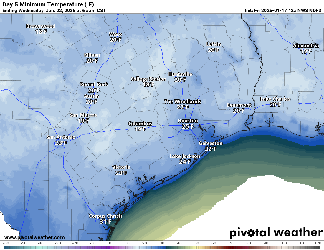
Wednesday morning hard freeze
With ideal conditions for cold weather, including fresh snow on the ground, you can expect Wednesday morning to be very, very cold. While it won’t be super cold across the rest of Texas, locally here in Southeast Texas, we may rival one of our coldest mornings of the last few years.
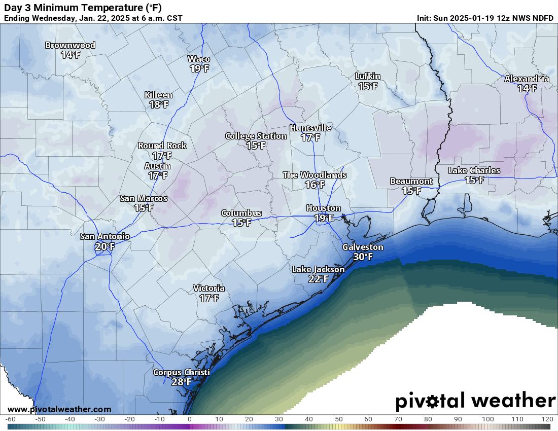
Expect lows in the teens virtually everywhere away from the coast. Areas that see minimal snow accumulation will also likely be milder. This will be a hard, damaging freeze and maximum cold weather precautions need to be taken.
Wednesday afternoon should see sunshine but with snow and a bitter cold start, we will likely only get into the mid-30s or so. Another hard freeze is possible Wednesday night, albeit much less cold than Wednesday morning. And we should bounce back into the 40s on Thursday. Alas, the snow will melt.
Anyway, we’ll update you on any changes later this afternoon. But hopefully this post answers most of your questions in the meantime. Stay warm!