In brief: Gorgeous weather allows the Houston area to exhale today before one more chance of storms on Saturday. The highest risk of significant weather on Saturday is east of our area into Louisiana and Mississippi, but a few noisy storms could impact a couple areas Saturday morning or afternoon. We have a gorgeous Sunday, followed by notably cooler weather after Monday next week.
As of this morning, the National Weather Service has confirmed at least four tornadoes across Southeast Texas.
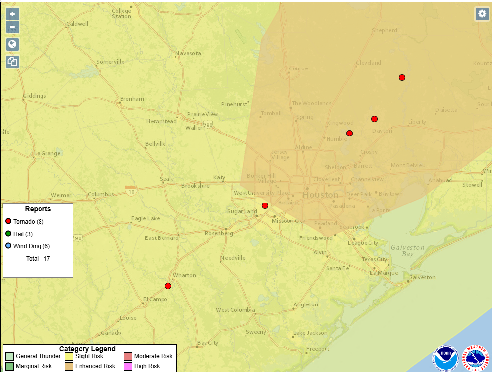
Two were in Liberty County, including one which damaged an RV park. A third was a waterspout that crossed from Lake Houston onto land for a short time. The fourth was the very well-documented tornado that occurred in El Campo to the southwest of Houston. A fifth possible tornado was reported near Sugar Land, and as surveys unfold today, we could see a couple more added to the board.
Overall, this was a pretty good forecast. A lot of our severe weather days here are on the margins; either the cap breaks and we get hit, or it holds and we get minimal action. Yesterday was an example of the rare case where it was pretty clear cut that we had a severe risk over the entire area but only a few spots would see the really bad stuff. Rain forecasting will always be more challenging to pin down, so from that point of view, your mileage may have varied this week. But overall, the last few days have not thrown us too many curves thankfully, even if it has felt a bit out of season.
Today
Take a breath today. Low clouds and fog may be with us for a bit longer south and east of Houston, but it will clear out and turn out to be a really nice day overall. Highs will be in the low-70s.
Saturday
The third in our parade of systems arrives Saturday. Each successive one has ended up firing up farther east than the previous system, and Saturday should be no different. This looks like a similar setup to yesterday shifted about 150 miles or so to the east. What does that mean for Houston? We are in a marginal risk (level 1 of 5) for severe weather. Rather than being hit directly by a bunch of storms, we are located where a lot of the storms will kick off. So look for isolated to scattered showers and storms to impact the area from early morning into mid-afternoon, with perhaps a slightly higher risk north and east of the area. However, the storm coverage should not be nearly like we’ve seen this week.
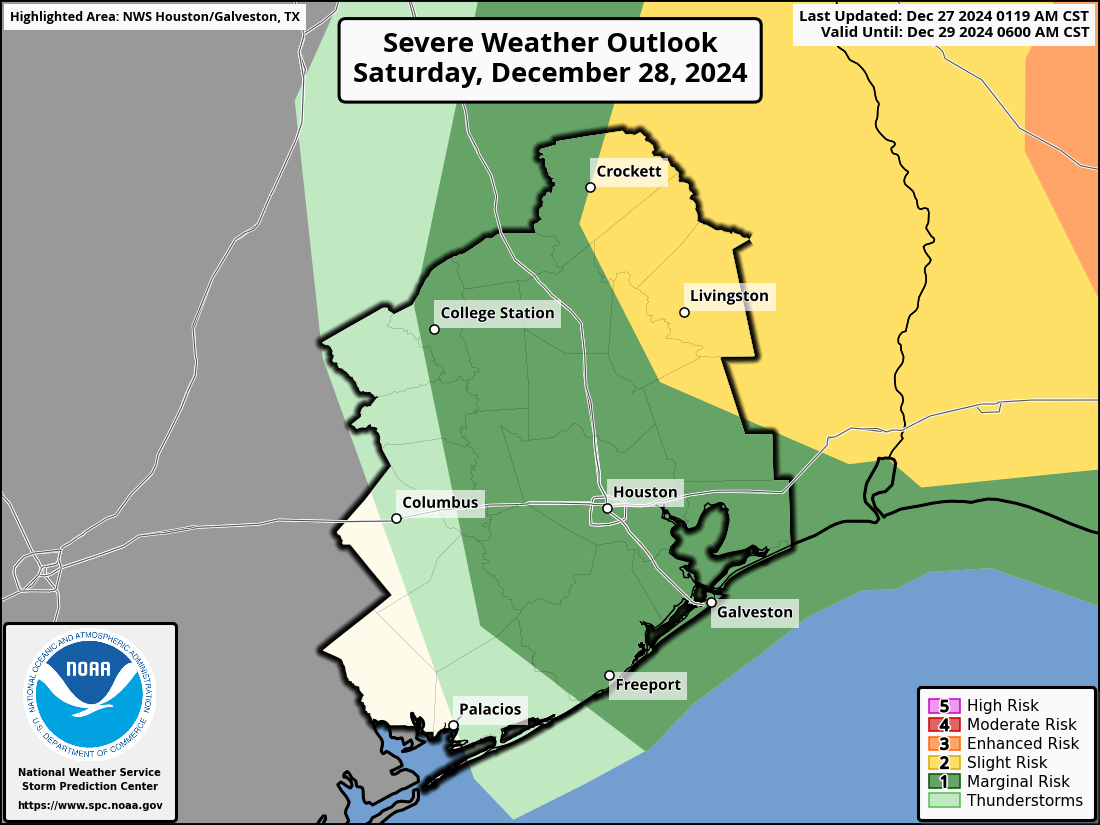
One potential exception to all this may be south and east of Houston, particularly on Saturday morning between 5 and 10 AM or so. As the initial surge of warmer air returns, it could come with some strong thunderstorms, and I would not be surprised to see one or two heavy, noisy storms in Galveston, Chambers, or Jefferson Counties on Saturday morning.
Otherwise, high temperatures will be mild, topping off in the mid to upper-70s, with morning lows near 60 degrees.
Sunday
We clear out again by Sunday morning, leaving us sunny and very, very pleasant with highs in the low-70s.
Next week
Monday starts off warm, with highs well into the 70s. It should remain sunny however. Our strongest cold front since before Christmas arrives on Monday night or Tuesday morning. This will knock us back into the 60s for highs and 40s for lows in Houston, perhaps a bit colder in outlying areas. This appears right now to be a dry cold front, so we do not expect much, if any rain beyond tomorrow.
Beyond next week
I guess there has been some speculation floating around about snow risk and freeze risk in Texas on the proverbial internet. The comments we have gotten from people have ranged from next week to the second week of January on the timing, which raises a red flag immediately. Look. It’s the time of year where, yes, we will be watching for cold risks in the long range that could be capable of producing a Texas freeze. We see nothing of that nature right now.
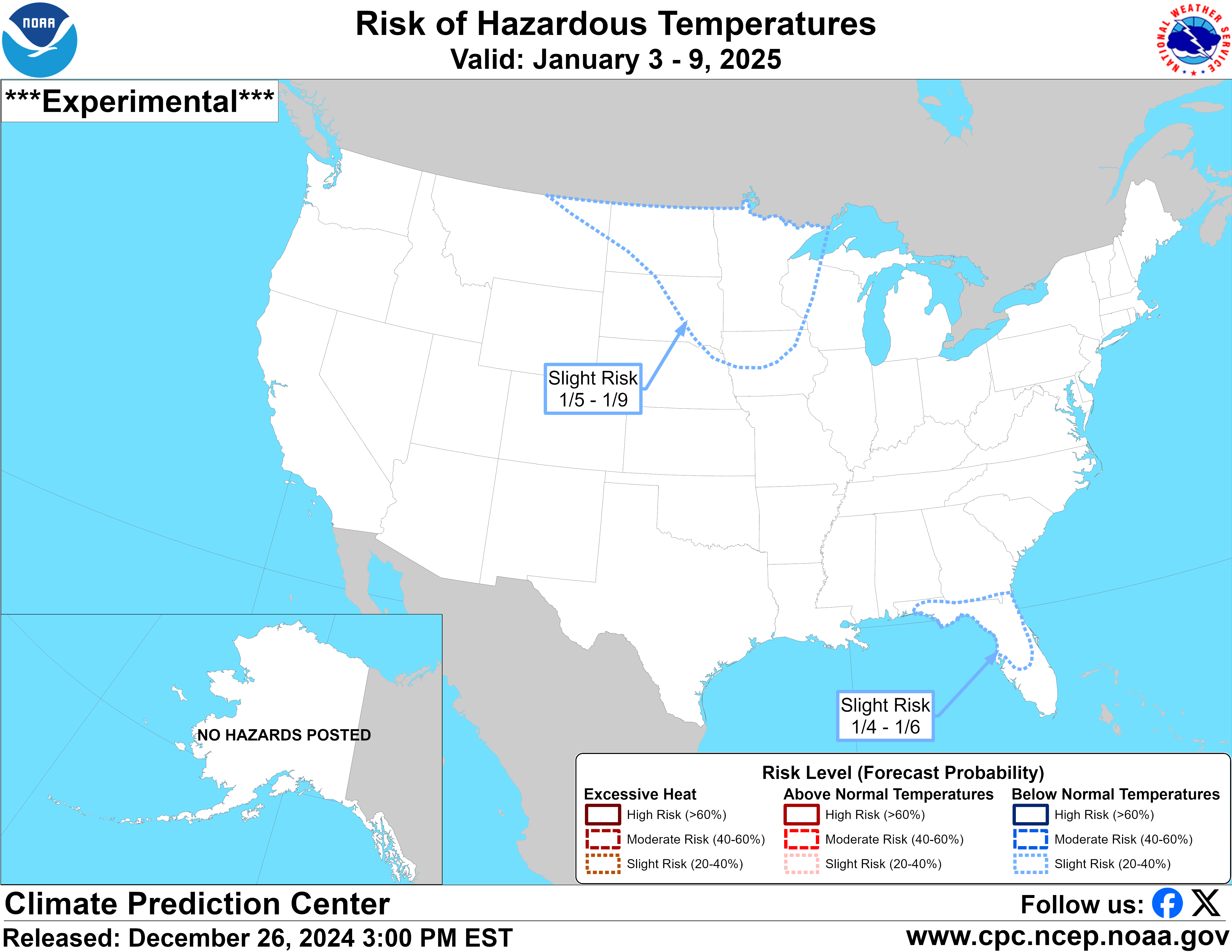
The Climate Prediction Center is also not outlining anything of note in their 8 to 14 day hazard outlook (which is where you’d expect to start to see warning signs of a freeze). So at this point, we aren’t too concerned about that.
As for wintry precip, we don’t see much risk of that in early January here in Houston. There are subtle hints on the GFS operational model, as well as in some AI model guidance that a very brief setup that historically has been favorable for wintry precip somewhere in Texas may occur midweek the week of January 6th. That’s a solid 10 days from now, so I would not be placing my life savings on that possibility. Also, Texas is big, so I couldn’t tell you if that’s an Amarillo risk, a Dallas risk, or an Oklahoma risk. But it gives us something, I guess, to watch after New Year’s.