It’s been a busy morning with a line of heavy rain and thunderstorms moving through. We even had a tornado warning in Brazoria County earlier from this vigorous little storm. As of just about 7 AM, the heaviest rain is east of I-45, with Galveston and Chambers Counties in line for the worst over the next hour or so.
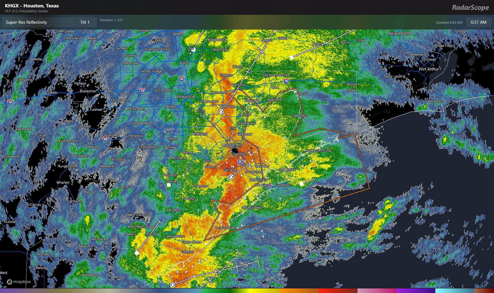
In addition to the rain, gusty winds of 40 to 45 mph are possible, especially in Galveston and Trinity Bays and near the coast. All of this will progress eastward toward Beaumont and Port Arthur through mid-morning with heavy rain and strong winds, as well as some embedded thunder. Most areas will finish with 1 to 1.5 inches of rain when all is said and done, with isolated higher and lower amounts.
Rest of today
Once this line of rain and storms exits to our east, we’ll be left with a few hours of showers or lighter rain and clouds this morning. By afternoon, we could see some clearing begin to push in from the west, so some sunshine may pop out, especially south and west of Houston before the end of today. Otherwise, look for highs in the 50s with a slight northwest breeze.
Weekend
This weekend looks splendid for the most part. There could be areas of fog overnight into Saturday morning, but I would expect those to clear out rather fast on Saturday morning. Otherwise, expect sunshine both Saturday and Sunday, with nothing more than the high clouds we’ve seen at times over the last month or so, especially south of Houston.

Both mornings should see lows near 40 or so in Houston proper and some upper-30s in the suburbs. Daytime highs will be near 60 on Saturday and probably the same on Sunday.
Monday
Next week is going to begin on an active note. From Sunday night into Monday, southerly winds will surge humidity in off the Gulf. At the same time, a storm system will kick start off the Rockies and move into the Plains, dragging arguably the strongest cold front of this winter across Texas. So what does it mean? A number of things.
First off, we’re likely to see winds pick up off the Gulf Monday, with gusts of 20 to 30 mph or even a bit stronger at times. We’ll all notice this.
It’s still too soon to really get into the finer details of things yet, but we are expecting scattered thunderstorms on Monday, and any of those storms could be on the stronger side. Right now it appears that gusty winds may be the biggest concern with any storms, but we’ll look at this closer through the weekend and report back with an update.
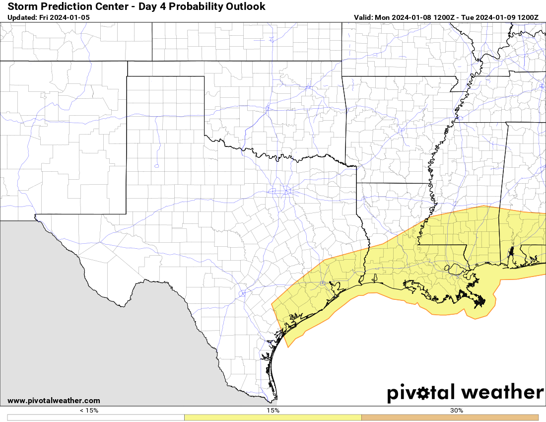
The Storm Prediction Center has us outlined for a slight (level 2 of 5) risk of severe storms right now. We’ll monitor this through the weekend.
Temperatures on Monday are also going to surge warmer, with highs likely in the 70s in the afternoon. Everyone should see a bit of rain but totals will vary widely depending on how storms setup. Again, we’ll fine tune this ahead of Monday.
For anyone heading to or visiting for the college football national championship, it’s entirely possible that you could head into NRG Stadium with temps in the 70s and leave with temps in the 40s or low-50s, so just be aware of that.
Rest of next week
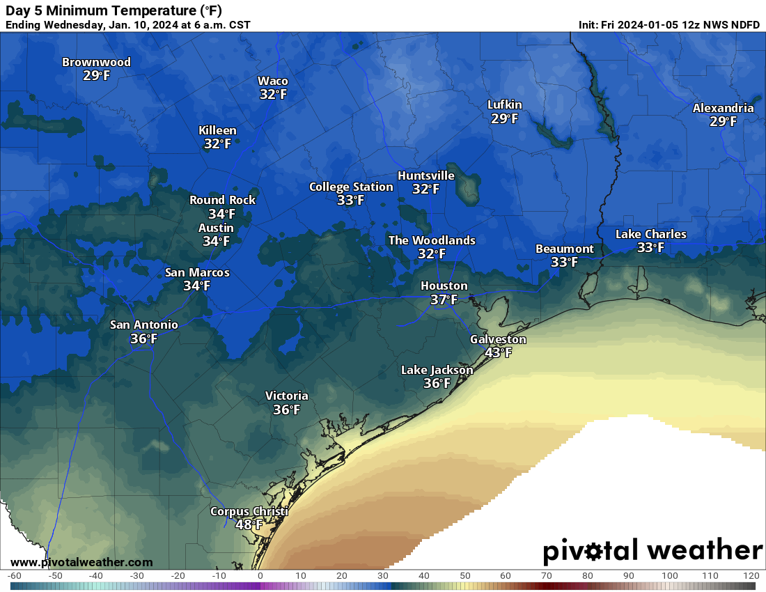
On Monday evening, a cold front will sweep through the area, likely ushering in strong offshore winds and much colder weather. Wind gusts of 30 to 40 mph or even stronger will be possible Monday night and Tuesday behind the front. Much colder air will plunge in with lows in the 40s Tuesday morning and highs only in the low-50s. This might be the coldest air mass of the winter so far, and the coldest morning will be on Wednesday, with morning lows in the 30s everywhere and a light freeze possible in the suburbs.
After that, we warm back up again with temps near 60 on Wednesday and back to near 70 or so by Thursday.
Houston Marathon
Many of you are curious about the Houston Marathon. The good news is that right now the timing of systems looks good for a cooler run. The question becomes “how cool?” We should see another system bring a front into the area probably some time on Friday, leading to a cooler, breezier Saturday. As of now, I would expect race start temperatures on Sunday to be in the 40s with hopefully light winds. We would probably warm up into the upper-40s or low-50s by the end of the run. More to come!


Welp, with the ground still saturated from last weekend’s rains, I think you’ll need to dust off the Flood Scale and have it ready for Monday’s rains.
This El Niño has been rather mellow so far,which is to say it has been quiet as far as the lack of an assembly line of disturbances that a typical Niño would bring. It looks like though that is changing. It’s making a comeback with these storms every 3 days or so. Its good in one aspect, were chipping away at the drought and positioning ourselves for summer.
There have been a few days between rain events this week to dry out. Also would depend how strong storms will be monday to decide on bringing up Flood Scale
It was hailing in my yard in Sweeny for a few minutes. I could hear it bouncing off the tin roof on my backporch. It was tiny hail probably smaller than pea size. There was tons of close CG lighting. The rain was torrential with 2.9 inches falling in my rain gauge in just an hour. It’s been since July 2021 since I’ve seen water this high down my road. It was an epic storm that I’ve been waiting a long time for. Fortunately the heavy rain stopped before any homes flooded. The water has receded quite a bit since the heavy rain stopped.
Last week my dad said we needed the rain, this morning he looked at our flooded lawn and shook his head! I still appreciate the rain but I do not like the mud, can’t have your cake and eat it I guess.
The wind blew a poinsettia off our balcony railing, fortunately it fell onto the balcony and not to the ground below. Our HOA frowns on plants on the railing, so maybe it wasn’t a bad thing ….
Ho moaners
As a ‘standing on the corner’ supporter of a runner in the marathon, I want it to be warm, sunny and around 70 degrees. I expect my runner will not agree with that.
really miss the balance and stability of the Holocene
🕯
We have had 2.13″ of rain here in Sienna Steep Bank East area. Most of it fell right around 6:00 am. Some wind, but nothing too strong. Temperature went from 60 to 53 in like three minutes. And lots of water puddling in the usual areas that do not drain well. Looks to be all past us now, but still cloudy. Survived another one.