In brief: More of the same is expected over the next few days in Houston, with cool-ish mornings and very warm afternoons, along with a good bit of sunshine. The weather pattern changes for a time next week toward humid with rain chances. Then, perhaps we can await our next front.
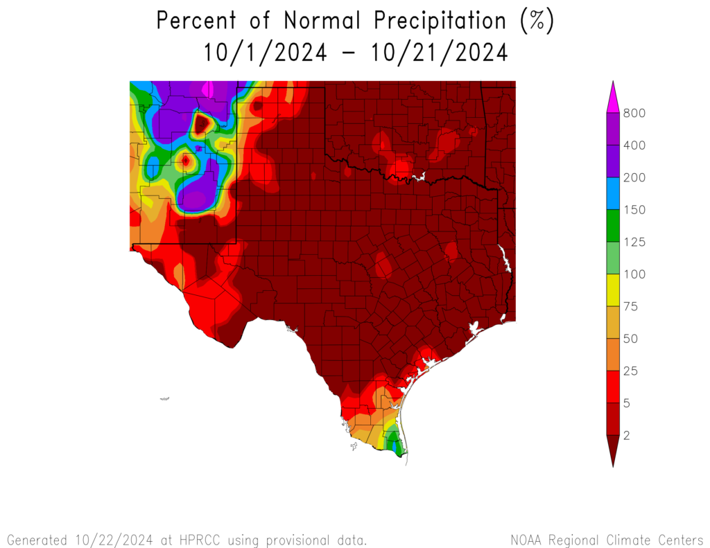
About 800 miles separate the two portions of Texas that have done well in the rain department this month: The mouth of the Rio Grande and the tippy top of the Panhandle. New Mexico has outperformed Texas, even with some serious flash flooding there recently.
Almost all of Texas has been dry this October. (High Plains Regional Climate Center)
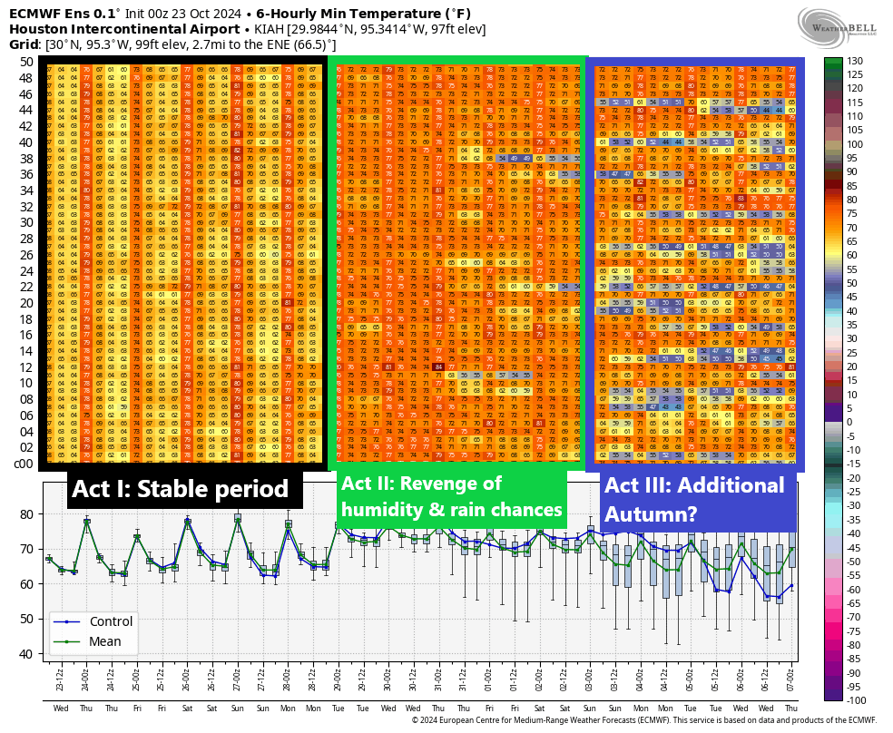
But in general, we are far from alone right now in this dry pattern. The next couple weeks will bring us more of the same but also some potential for change, particularly next week. I think looking at the European ensemble for low temperatures the next two weeks shows how the pattern splits into 3 differing acts of weather.
The 50 member European ensemble gives us a three-part flavor to the weather over the next two weeks. (Weather Bell)
Act I: The stable period through Sunday
Over the next several days, things will be pretty calm. We can expect daytime highs in the upper-80s, just a couple degrees shy of daily records. But if you want some autumn flavor, the mornings will remain fairly cool, in the 60s. These temperatures are still solidly at least 8 to 10 degrees warmer than usual. Rain chances will remain nil. We will get a weak reinforcing shot of drier air Friday that should extend this weather through at least Sunday and possibly Monday.
Act II: Revenge of humidity and rain chances
Next week sees a change. We’ll have both more unsettled weather and increasing rain chances, as well as much more humidity. Overnight lows will likely shift into the low-70s, about 10 to 15 degrees warmer than normal, while daytime highs will hold steady or even fall a few degrees due to clouds and rain chances.
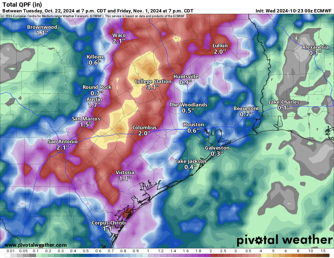
I think we want to be realistic about rain chances next week. In a drought, sometimes you find ways to fail, and while I would still expect at least an inch or so of rainfall from scattered thunderstorms next week, the heavier rains, the 2 to 4 or 5 inch totals will probably be confined to a narrow corridor somewhere in the area along or northwest of highway 59. Something we will continue to watch. The European operational model shows this well below as a possible example of what could occur.
European operational model rainfall forecast for next week shows a narrow band of 2 to 5 inches of rain, with most other places seeing 1 to 2 inches or less. (Pivotal Weather)
Regardless, we will see just a warm, humid, un-autumn-like week next week.
What this means for Halloween remains partially unclear. There will almost certainly be a chance of rain, but it will almost certainly also be warm. So plan for warm right now, but check back with us on the rain chances which may not become clear until early next week.
Act III: Additional autumn?
After next week’s pattern shift, we could see a return to something more typical for autumn. I would say there’s probably a 40 to 50 percent chance of a meaningful cold front around next weekend. The exact timing is uncertain, but there’s enough signal in the models for us to think there’s a decent chance. We’ll keep watching.
In brief: Go outside, ideally away from central portions of Houston and look north after dark tonight, and bring your phone and take pictures! We have links to tips for using your phone camera below.
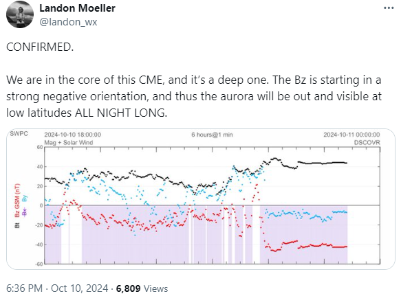
Earth is in the crosshairs of a coronal mass ejection (CME) tonight, perpetrated by a solar storm. No need to panic. In fact, this may be an opportunity you rarely get: A chance to see the northern lights at extremely low latitudes. Social media is flooded with photos from all across the Northeast and Mid-Atlantic of bright, strong auroral displays.
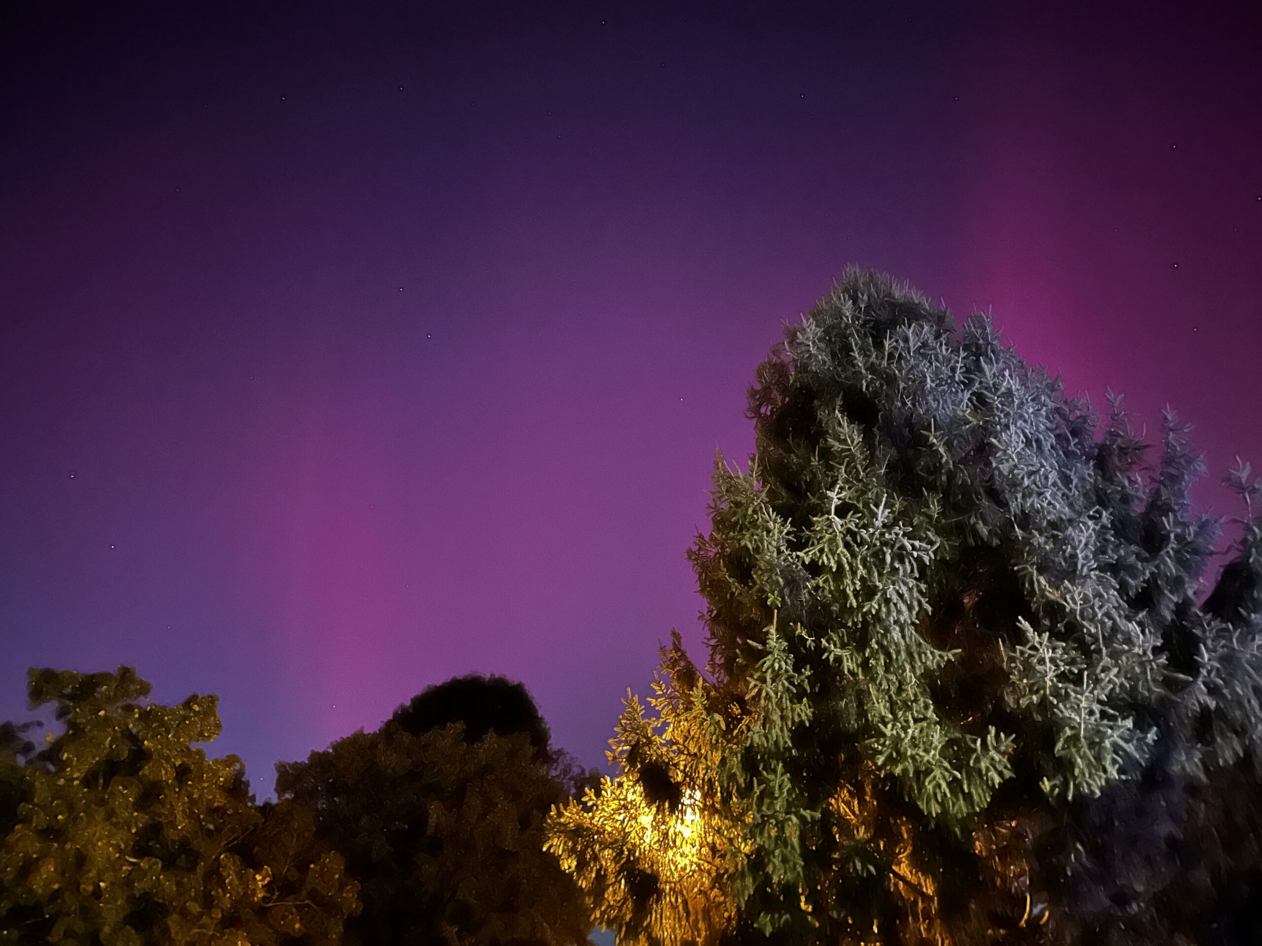
My sister in Bear, Delaware sent me this photo earlier this evening. (Steph Helgeson)
There have even been photos as far south as Nassau in the Bahamas of the aurora — again. This happened back in May when an auroral display triggered some pictures sent to us from Conroe and elsewhere up north. This storm may be a bit beefier and skies are absolutely crystal clear, so there may be opportunity to see this over more of the region tonight. We can’t promise anything, obviously, as solar storms are fickle creatures, but the data supports the potential for an aurora here in Texas.
One day, we’ll post more about the science behind this and why it takes such a strong storm to allow the northern lights to be visible this far south. In the meantime, there are a few things you should consider if you try to photograph the aurora tonight. The links below will help you. Go forth and conquer.
In brief: Houston will continue a string of hot days, but the nighttimes should become a bit more pleasant as well. A cool front on Monday will take care of that for us. Rain chances this weekend are mainly at the coast and mainly just scattered, and no real rain is expected next week. We have no tropical concerns in Texas.
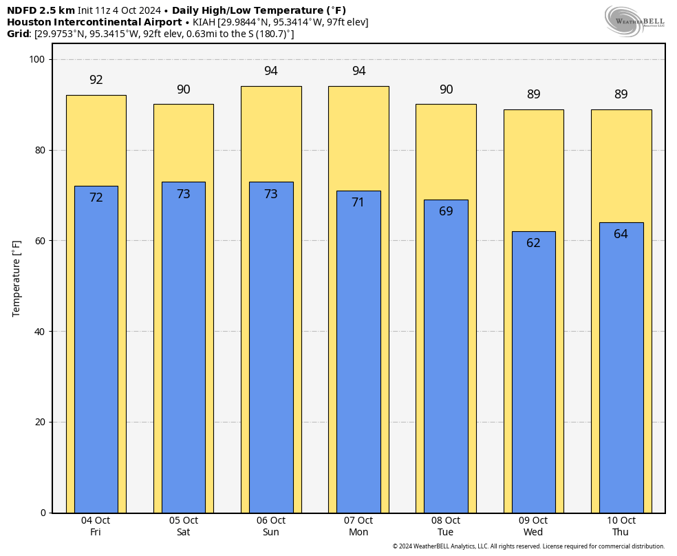
There have only been two somewhat similar times that Houston has been through such a persistently lengthy stretch of hot weather so late in the season: 1904 and 2007. The 1904 stretch ended around October 12th, whereas the 2007 stretch ended on October 4th. So when can we get past this faux fall situation? Maybe soon? Maybe. But honestly, looking at the NWS forecast below, this string of upper 80s or hotter during the day may have another week left in it.
Temperatures as forecast by the NWS over the next week look very hot for October during the day; less warm at night though. (Weather Bell)
The good news in all this is that the nighttimes are running out of punch, and we should see lows in the 60s behind an expected cold front on Monday night or Tuesday. That front will also protect us from any tropical riff-raff in the Gulf of Mexico.
Today and Saturday
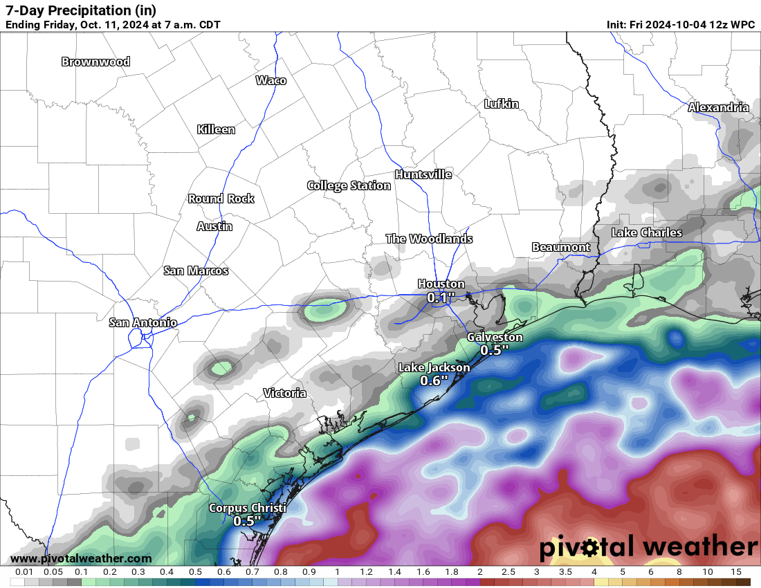
We already have a bunch of showers offshore this morning. We may see some of those work their way ashore through the day today. I have to be honest though: Consider yourself lucky if you see any rain.
Total rainfall over the next week will be ample over the Gulf of Mexico but much less over land. (Pivotal Weather)
Tomorrow should play out similarly, though I think the coverage of showers will be just a wee bit higher. Still, for the many fun weekend events we have happening in the Houston area this weekend from the Dash tonight to Southern Smoke to the Komen Race for the Cure, our forecast is that other than perhaps a passing shower or two, conditions look fine. Just stay hydrated, as it will be warm and somewhat humid this weekend.
Sunday
Rain chances will begin to slip slide away on Sunday. Texans tailgating will be a bit muggy but other than maybe a passing shower, it should be fine. We’ll be back into the 90s for highs.
Monday and Tuesday and beyond
We will get one push of drier air late Sunday, followed by another, stronger push of dry air Monday night or Tuesday morning with an actual cold front. This is really going to take a bite out of humidity levels, and it will feel extremely comfortable by the time we get to Tuesday. Even with hot afternoons, it will be a decent stretch of warm days and cooler nights for mid to late next week. But again, no real rain chances.
Tropics
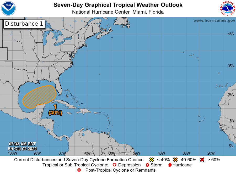
We’ve been covering the tropics extensively over at The Eyewall, and we will continue to do so through the weekend.
While there is a 40% chance of tropical development in the Gulf, it is not a concern for Texas. (NOAA NHC)
There will be a sloppy situation evolving in the Gulf of Mexico over the upcoming week where tropical development is possible to some extent. But because of our push of dry air to start next week, everything will get pushed east of us toward Florida. If you’re planning a trip to Florida, just keep tuned into the forecasts and maybe prepare for rain through Wednesday or Thursday of next week. Then hopefully things quiet down.
In brief: We are sharing a post we just published on our tropical companion site The Eyewall that talks about the next system expected in the Gulf this coming week. At present, we think it will likely stay east of Texas and is more a concern east of New Orleans to Florida. Still, we’ll watch it to be sure. We also have some links for folks that may want to help our neighbors in Appalachia that are dealing with an absolute catastrophe due to Helene.
Our thoughts are with folks impacted by Hurricane Helene. From what I have read and seen and heard about some parts of western North Carolina and Tennessee, it’s really, really bad. Worse than might be known at this point. Speaking as someone from Houston, which was has dealt with floods and then been flooded with resources after storms, these more rural communities are likely to be dealing with this for a long time and will need a *lot* of help in the weeks and months ahead, as the resources and media attention don’t always focus on places like that.
Keep in mind that after catastrophes like this, “stuff” is nice to donate but what is really needed is money. So consider that if you’re looking for ways to help. The United Way of North Carolina has a fund setup specific for Helene. Blue Ridge NPR has a nice list of organizations you can donate to as well. There is also the East Tennessee Foundation for folks there. Please post any other organizations in these areas in the comments.
As of late Sunday morning, there are still about 2.5 million customers without power from Florida to Ohio. This is down from a peak of around 4.5 million. It will take a long time to get to some areas in mountainous and rural western North Carolina and eastern Tennessee though, and some of these locations could be without power for weeks; the damage is just that complete in these areas.
Storm surge is the deadliest aspect of a landfalling hurricane, but inland flooding can dwarf that sometimes. We’ve seen it time and again in the last several years. If you live inland in the Southeast, Mid-Atlantic, or Northeast, you need to be prepared for hurricanes too.
There will be a lot more to discuss with Helene which we’ll save for another day. But suffice to say we have seen the worst-case scenario play out a lot more often in recent years. And this is going to be a big discussion point going forward both in how forecasts are communicated and how communities prepare for storms. You can’t rely just on the known lessons from past disasters anymore.
Forecast this week
The upper low and remnants of Helene will continue to produce generally light showers across the Midwest and East the next couple days before finally being ushered off to the east later this week. There will be pockets of steadier rain though, particularly in Virginia and West Virginia. Total rainfall over the next 5 days could add up to a couple inches there.
Rainfall through Thursday should be heaviest in Virginia and West Virginia as the broader storm containing Helene’s remnants slowly exits. (Pivotal Weather)
Localized flash flooding is possible today and tomorrow in the mountains there or Shenandoah Valley. These areas were not as severely impacts as areas to the south, but they remain vulnerable to localized flash flooding impacts.
Gulf & Caribbean: Something to watch
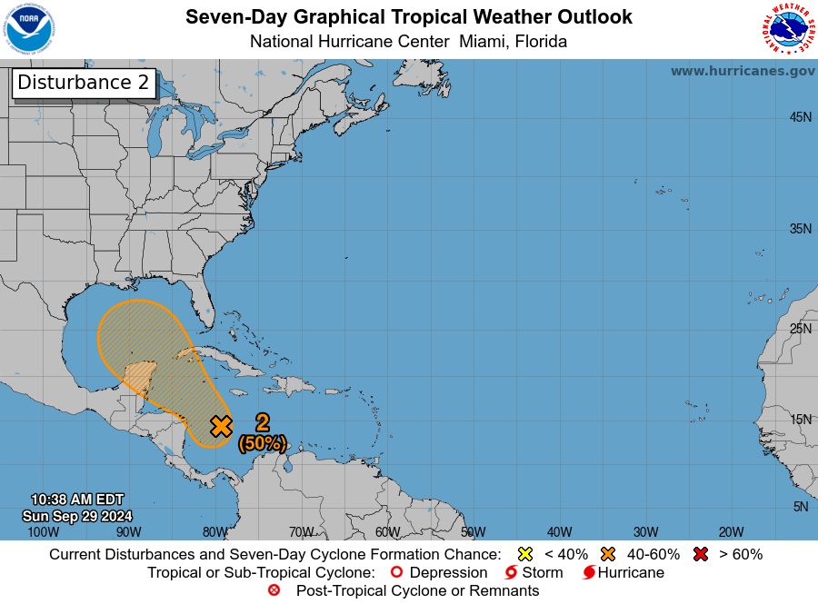
So what comes next? Unfortunately, the NHC now has a 50 percent chance of development somewhere between the Gulf and northwest Caribbean over the next 7 days.
A disturbance emerging from a Central American gyre type setup will carry a 50 percent chance of development this week in the Gulf or Caribbean. (NOAA NHC)
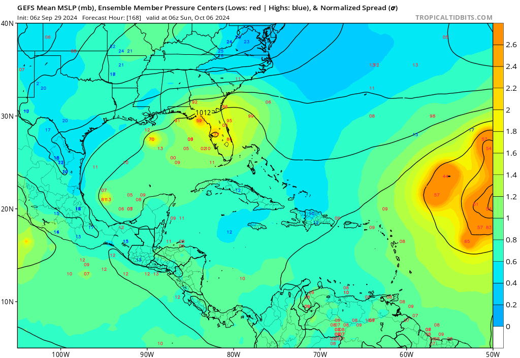
For our many readers in Texas, at this point, I would not expect this disturbance to come this far north and west. It will take at least the next 3 to 4 days to develop, and by the time it matures enough, it appears a cold front is headed toward the Gulf that will likely carry this back to the north and east. What this means for places from New Orleans through Florida is still a bit unclear. Modeling is sort of all over the place. At this point with Helene, we had basically two very distinct camps, one that buried the storm near the Yucatan and another (that got it right) carrying it north and northeast as a stronger storm. For this system, we have a similar sort of mixing of outcomes but there’s not exactly a distinct grouping of camps. In other words, there’s a good deal of uncertainty. The GFS ensembles are mixed, with some favoring a stronger storm headed back toward Florida and another group that ends up weaker. Some modeling doesn’t develop this at all. The ICON and European AI models generally show slower development and slow movement.
The GFS Ensemble from last night has some members carrying this disturbance toward Florida, a handful keeping it buried in the Gulf, and others still that never develop it. (Tropical Tidbits)
Given the uncertainty here, it’s important to continue to monitor this over the next couple days, especially in the eastern Gulf. But I will say that the more mixed nature of things in modeling makes me feel that a Helene redux is unlikely in this scenario. That said, keep watching. Impacts, assuming the system develops would likely occur next weekend.
Elsewhere in the Atlantic: Kirk to come
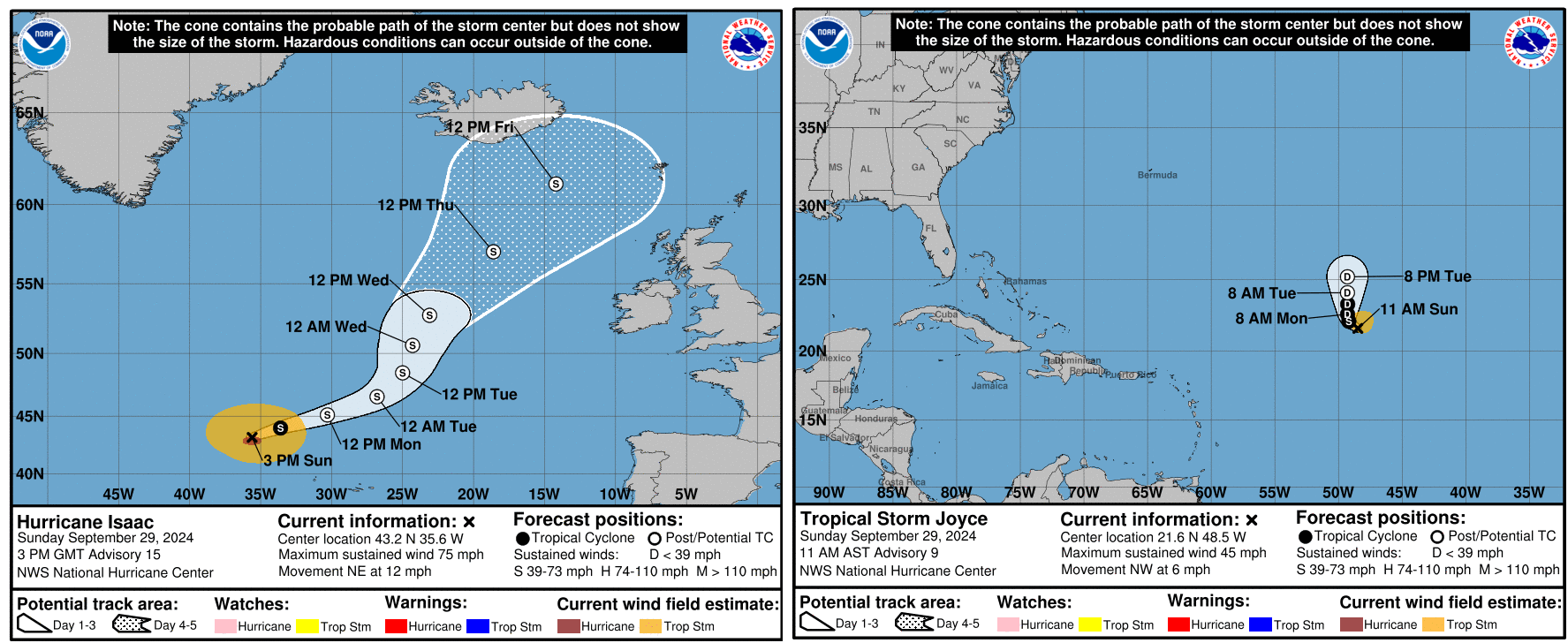
We currently have two active systems, Hurricane Isaac and Tropical Storm Joyce. Neither are direct threats to land.
Isaac and Joyce are likely headed toward dissipation soon. (NOAA NHC)
Both storms should lose tropical characteristics over the next 3 to 4 days and dissipate. Isaac will become part of a larger storm just north of the British Isles, as is periodically the case with North Atlantic storms.
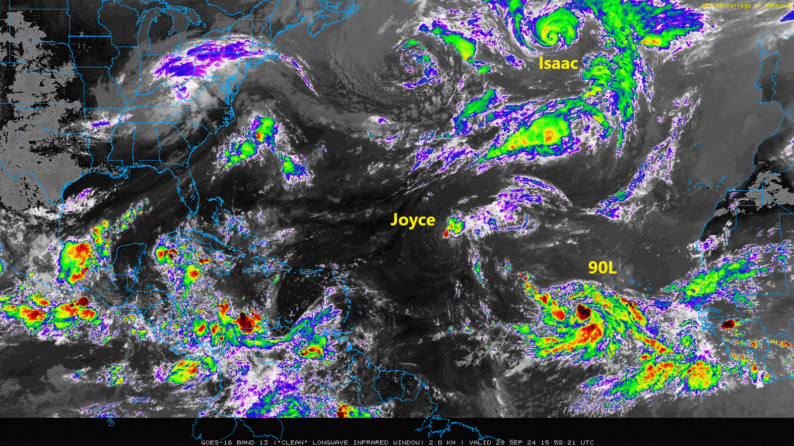
Meanwhile, there are two additional areas to watch in the eastern Atlantic. First, there is Invest 90L, which looks like it’s ready to go off to the races. This one should turn northwest and north, generally following Joyce.
A busy Atlantic to close September. (College of DuPage)
The next name up is Kirk. Although this one is expected to go out to sea it’s worth keeping a side eye on for the Caribbean and Bermuda at least.
Behind 90L we look to have another disturbance in that cloud cover back off Africa. This is not expected to develop quickly meaning that it could come a bit farther west across the Atlantic. I might say that this one is more concerning in some aspects that what should become Kirk. If this can sneak west enough, it may find its own little environment to get going in. There’s not a ton of model support for this one either way, but interests in the Caribbean should at least keep an eye on it over the next 5 to 7 days as it comes west.
So over the next 7 to 10 days we likely have at least one more Atlantic storm and one more Caribbean or Gulf system. We may get a third storm in the Atlantic toward the end of that time horizon. Getting to (L)eslie or (M)ilton would put us at 12 or 13 storms for the season with a good 3 to 4 weeks of potential to go. Still far short of preseason expectations but somewhat less of an error. We’ll watch everything over the next couple weeks and keep you posted.