In brief: Following a splendid Memorial Day in Houston, we are going to see the brief return of potentially heavy rainfall on Wednesday. Note that these storms may hit during the morning commute. The weekend looks warmer, and mostly rain-free.
Look back at last week
Before we look ahead, I wanted to briefly review our rainfall totals last week, from Sunday morning to Sunday morning. Most areas along and south of Highway 59/Interstate 69 picked up 3 to 6 inches of rainfall whereas inland areas were more in line with 2 to 4 inches. For much of the region (excluding areas south of the region) the bulk of these rains came on Saturday, when there was flash flooding.
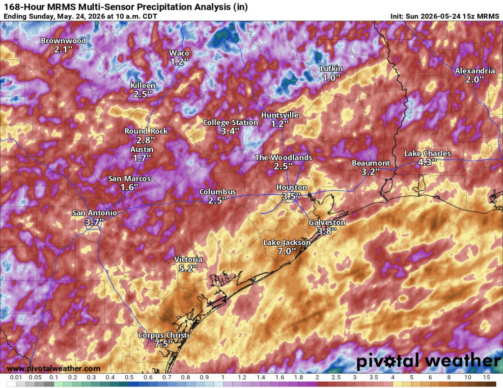
These rains were largely beneficial for most areas. As the Houston region enters the hottest part of the year, with the highest Sun angle, our soils are largely drought-free. It is a great position to be. You may also note on the map above that areas south of Houston, along Coastal Bend, also received healthy rainfall totals last week. This has had a beneficial impact on one of the two main reservoirs that provide water for Corpus Christi. Although Choke Canyon has largely been unimpacted, Lake Corpus Christi is now 14.7 percent full, an increase from 8.7 percent full a month ago. This will provide the region a little more time to sort out its severe water shortage issues.
Tuesday
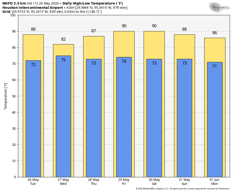
If you enjoyed Memorial Day—and it ended up being a rather nice holiday for outdoor, sunny activities—today should be similar. High temperatures will push into the upper-80s, with partly to mostly sunny skies. Winds will generally be light, from the southeast at about 10 mph with slightly higher gusts. Rain chances are low, perhaps 10 to 20 percent. Rain chances increase tonight, especially after midnight.
Wednesday
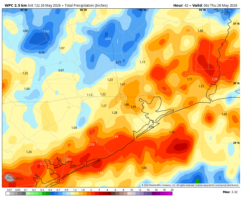
An atmospheric disturbance will move into the region overnight on Tuesday from the west, and likely push an area of storms through the region early on Wednesday. At this point I think the best chance for widespread showers will occur between 4 am and noon on Wednesday in Houston. Flooding is possible, of course, but for most of the region accumulations look to be between 1 and 2 inches. This should be manageable, but definitely worth monitoring given that these showers and thunderstorms are likely to move through during the morning commute. Highs on Wednesday will likely top out at about 80 degrees, with lower rain chances likely during the afternoon and evening hours.
Thursday
We can expect some lingering showers on Thursday, but coverage and amounts should be significantly less than on Wednesday. Skies will turn partly sunny and highs likely will push back into the upper 80s.
Friday, Saturday, and Sunday
We probably will see high temperatures rise to about 90 degrees beginning on Friday, and lasting through the weekend. This is on par for this time of year. Skies look to be mostly sunny on Friday, with partly sunny conditions on Saturday and Sunday. With dewpoints in the low- to mid-70s we’re getting there in terms of summer-time humidity in Houston, but just know it can get worse than this. (And it will, hah). Overnight lows will be in the mid-70s. Some rain chances return later on Sunday, although they look iffy to me at this point.
Next week
Rain chances rise to start next week, and there is some evidence that a weak front may approach Houston. Anyone betting on a cool front in June is probably a fool, so I’m offering no guarantees here. But there is a chance that some slightly cooler and drier air arrives later next week. If so, it would definitely be a bonus. We’ll see.
