Summary: The weather looks drama-free over the next week or so. After another chance for 80 degrees today, a cool front takes the edge off tomorrow and this weekend. Another warm up ensues next week, followed by another front after midweek. Neither front seems likely to pack much punch right now.
Eric and I are here to keep you informed about the weather in Houston. It’s a duty we enjoy and take seriously. In times of quiet weather, we never complain. We’ve seen what bad weather is capable of here, so when the weather is quiet, we relish the fact that we can tell you so.
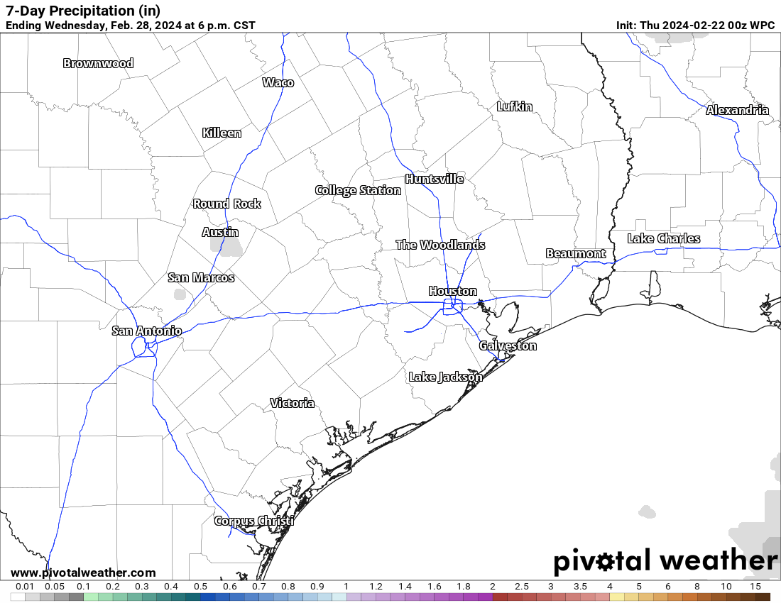
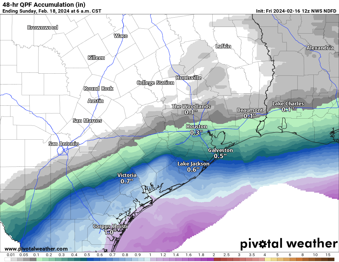
This isn’t just a blank map of Southeast Texas. It’s the forecast rainfall for the next 7 days from the National Weather Service. Congratulations on nothing! (Pivotal Weather)
I’m not going to complain because I’m struggling to fill a post with forecast information because it’s all some variation of the same thing, with the temperatures tweaked a bit here and there. I most certainly got my degree in meteorology to forecast lengthy stretches of lovely spring weather in February. Absolutely. No complaints here.
No, but in all seriousness the weather looks pretty calm with no real concerns through next week. Seriously, good for us!
Today and Friday
Look for clouds and sun today. We have avoided the 80 degree mark so far this week, so will we do it today? We’ll see. That will be the only real drama today. Maybe someone can squeeze out a raindrop or two ahead of tonight’s front. For once, it seems the Rodeo Cook-Off will not be cold or drizzly or extra windy or gross. Temps should drop from the mid-70s or so into the mid-60s through the event this evening.
That front moves through between about 7 PM and Midnight. Temperatures will steadily drop everywhere through the 70s and 60s and into the 50s overnight.
Friday dawns sunny with lower humidity and highs in the 70s. No issues at all for any of your plans, be they Rodeo, BBQ, work, or frolicking down the streets professing your joy for this weather.
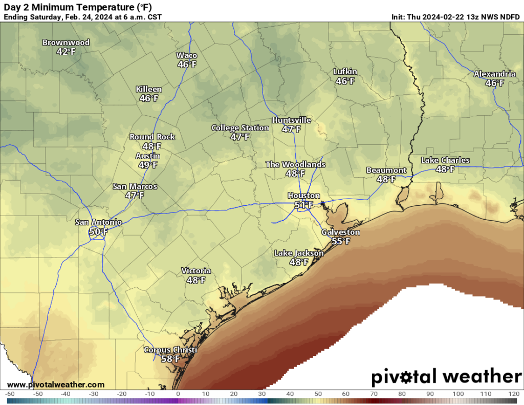
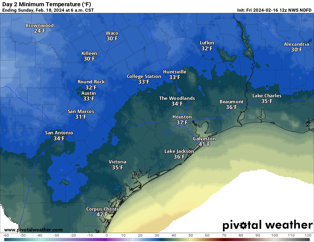
Morning lows on Saturday will be in the 40s and 50s area-wide. (Pivotal Weather)
Weekend
SUN-sational! Highs will be in the 70s, with lows in the 50s and 40s across the region on both days. Just a delightful pair of days.
Next week
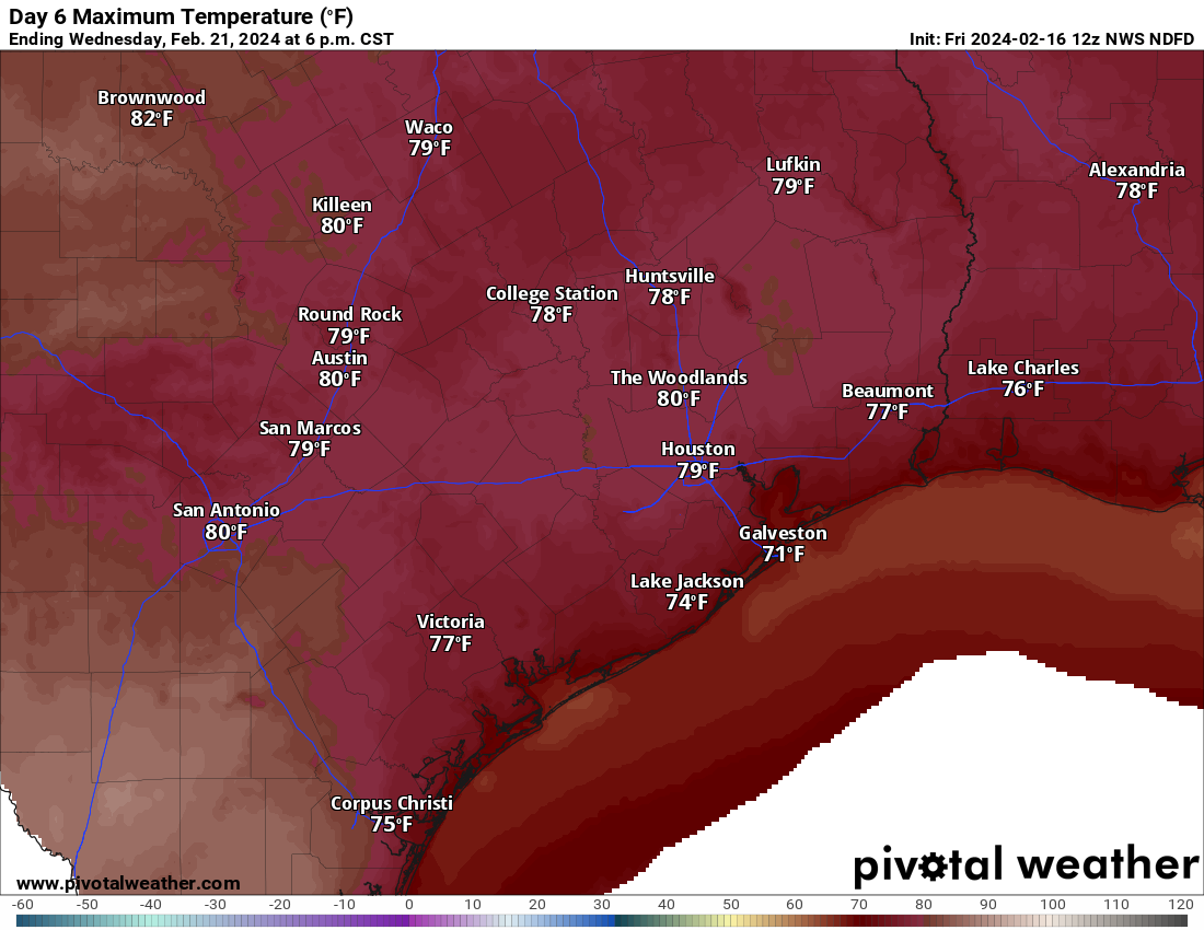
The main drama next week will probably be a day or two of gusty onshore winds. Nothing serious, but certainly something you’ll notice. We should see highs near 80 degrees Monday through Wednesday, with morning lows in the 60s. It will feel very, very spring-like. Our next front hits on Thursday with at least a slight chance of rain, but honestly, the odds of meaningful rain look pretty low right now.
After one of our wettest starts to a year, things have really slowed down. We’re probably getting to the point where we could use a little more rain. But for now at least, that’s not on the horizon.
Summary: A couple more very warm days are upon us before a Thursday night front cools us down just a little for Friday and the weekend, mainly in the mornings. We warm back up again early next week with another possible front after Tuesday. Rain looks to be at a premium over the next week or so.
Before we begin today, there was an article published yesterday by AccuWeather that sounded the alarm on the upcoming hurricane season. It singled out Texas as being at higher risk than normal as well. Over at our companion site, The Eyewall, I have a post up this morning explaining why we think it will be an active hurricane season but also why we believe it’s too soon to be singling out specific places. I have to warn you now: The next few months are going to be chock full of noise about the upcoming hurricane season. It does look setup to be active. We will continue to share what we know and what we think here and over at The Eyewall so you can make sense of what you might hear or see shared on social media.
Today
We’ve got some fog out there this morning, so use caution through 8-9 AM or so. Houston officially rocketed to 78 degrees yesterday, oddly the same temperature we hit exactly one year ago. But it likely begins a somewhat lengthy stretch of 70 degree days in Houston. Look for warm temps again today, with a chance at hitting 80 degrees in spots. Winds will be noticeably gustier today, at times 25 to 30 mph. Overall, a windy, mild day. For those of you that suffer from seasonal allergies, get ready.
Thursday
Expect a few more clouds tomorrow with morning lows in the 60s and daytime highs around 80 degrees or so. I don’t know if “humid” is the right word, but it will feel a little “thicker” outside.
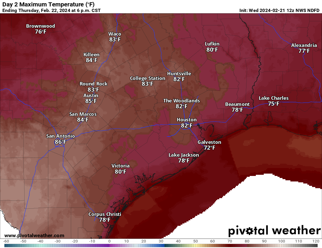
Tomorrow looks very warm, with highs in the 80s, though a bit cooler near the coast. (Pivotal Weather)
Our next cold front will be moisture-starved and hit right around midnight tomorrow night. Maybe a few raindrops could get squeezed out ahead of the front Thursday afternoon, but I’d probably be more likely to bet on the Oakland A’s to win the World Series this season.
Friday
With the front past us on Friday, expect a lovely day: Sunny, with morning lows in the 50s, warming into the 70s.
Weekend
If you want stereotypical spring weather, this is absolutely your weekend. The streak of rainy weekends is in the past. Look for morning lows in the 40s and 50s with daytime highs in the 70s Saturday and upper-70s Sunday.
The National Blend of Models offers a decent guess at temperatures over the next 10 days. Look for another warm up early next week before less warm weather kicks in mid to late week. (Weather Bell)
Early next week
I’d expect a pair of warm days Monday and Tuesday with increasing cloud cover. A slight chance of rain may enter the picture midweek with our next front knocking at the door. But details on that one are TBD right now. Either way, expect a slight cooldown after next Tuesday or Wednesday.
Summary: A mostly gentle rain is expected for most of the Houston area today, with the steadiest falling near the coast or down toward Matagorda Bay. A cold front will usher in a blustery overnight and Saturday with temperatures dropping into the 40s, before a spectacular Sunday and Monday. We’ll likely be talking 80s by midweek next week.
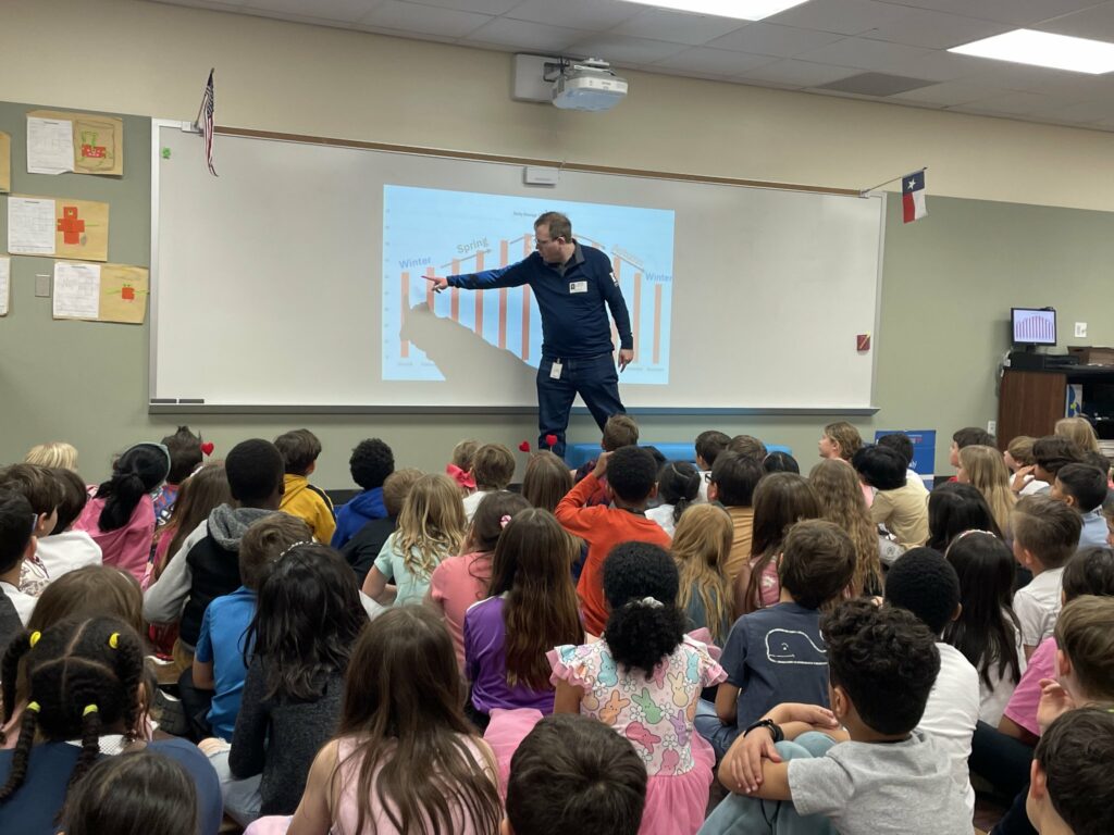
Before we get into things today, I want to give a shoutout to the second graders at Creekview Elementary up in Tomball. I got to visit them yesterday and answer all their weather questions, most of which happened to be about tornadoes! Some bright kiddos, and a thank you to Kristin Pesz, Tiffany Major, and the rest of the second grade teachers for having me out and for a couple special gifts!
Alright, let’s jump into the forecast.
Today
We’ll end the week on a wet note. This looks like the rare Houston steady rain that doesn’t dump all at once. This should be a rather gentle light to perhaps moderate rain most of the time in our area. Most of the area should see at least some rain, but the odds drop off, ahem, precipitously north of Highway 105.
Additional rainfall expected today into tomorrow. The highest amounts will be near Matagorda Bay and on the coast. (Pivotal Weather)
Areas south of Houston will see the most rain, which is to say a half-inch to inch perhaps, with the highest amounts down near Matagorda Bay. For Houston, totals will probably range from a few hundredths of an inch up near Conroe to a quarter to half inch south of I-10. Temperatures won’t move much today, with 60s this morning, increasing just a few degrees this afternoon.
Late tonight & Saturday
It will not be until about midnight or so, give or take an hour or two that we notice a big time change. A cold front will hit, which should taper any rain off to drizzle mostly. But behind it, fairly potent north winds will usher in cold air. Look for gusts of 20 to 30mph, stronger on the coast or near the Bay. And temperatures will probably hold steady in the mid to upper 40s at best. It will remain mostly cloudy with a few showers or some light rain around through the day, particularly south or east of Houston.
Sunday morning will be much less windy, but it will also be quite chilly, with frost or a light freeze possible, especially north and west of Houston. (Pivotal Weather)
Sunday
Winds calm down Saturday night, and Sunday will dawn calm and chilly. Look for lows in the 30s over a good chunk of the region. But Sunday’s daytime looks absolutely stellar, with temperatures rebounding well into the 50s to perhaps near 60 in spots. Oh, and it’ll be sunny. Definitely one to enjoy!
Presidents’ Day
Monday looks fantastic, with sunshine, morning lows in the 40s, and daytime highs near 70 degrees. Another stellar day.
Rest of next week
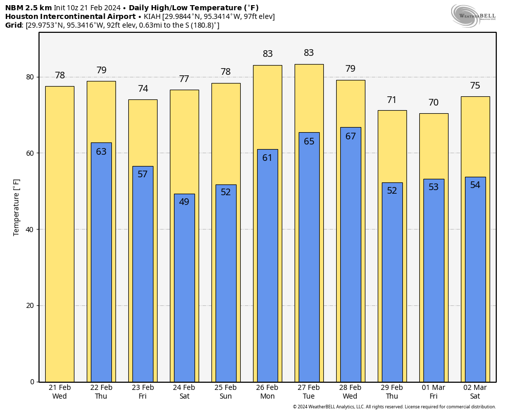
The warm up does not stop there. We will continue to add a little humidity and warmer temperatures Tuesday, Wednesday, and Thursday. I expect highs to hit the upper 70s Tuesday, and 80 or better Wednesday and Thursday. Current model guidance from the National Blend of Models (NBM) suggests at least a 50 to 60 percent chance of 80 or better on both Wednesday and Thursday. Lows will bump up into the 50s to near 60 degrees perhaps by Thursday.
There’s at least a 50 to 60 percent chance we hit or exceed 80 degrees on Wednesday and Thursday according to the National Blend of Models. Wednesday’s forecast temps are shown here. (Pivotal Weather)
No real meaningful shower chances are expected right now, but this warm pattern may allow for some sea fog in Galveston or along the bayshore. A cold front should nudge through the area Friday, allowing for cooler, dry weather next weekend but nothing too excessive. We’re probably looking at 40s and 50s for lows and 60s or 70s for highs. More on that next week.
Summary: An area of heavy rain is expected to setup just northwest of Houston on Saturday, while the rest of the area sees mostly scattered showers. Exactly where this sets up will mean the difference between a washout and some nuisance showers. No serious flooding concerns are expected. Another wave of rain passes to our north on Sunday before cooler, drier weather builds in Monday. Most of next week looks quiet before we watch, sigh, more rain risk next weekend.
Today
Expect a mix of clouds and maybe a touch of sun today. Some coastal fog may drift in and out through the day, so if you’re down in Galveston be aware of that. Otherwise, much like yesterday a few showers should float across the area today, so you may encounter a brief downpour or two through the day. This seems likeliest north of Houston. Highs should again be in the mid-70s.
There will be a sharp gradient within the Houston metro area between a few inches of rain and less than an inch of rain, with the most likely area to see heavier rain just north and west of the city. (Pivotal Weather)
Saturday
Time to plan around another wet weekend. At this point it appears that showers will begin to break out just before sunrise south of Houston and lift northward through the city in the early daylight hours. By mid to late morning, we will be watching for basically a conga line of rain and thunderstorms to establish somewhere in the area along a stalled frontal boundary.
Admittedly, this is a little tricky. Stalled fronts can be a royal pain to try and pin down, but the best data we have at this point says that this line of rain and storms will predominantly focus north and west of downtown Houston. Where will that be? The axis from Sealy through Magnolia through Conroe through Lake Livingston is probably the most likely corridor to see this heavier rain. As of this moment. Could that shift south and east some? Absolutely. Could it shift further north and west away from the area? Absolutely. Under that axis it will be close to a washout. A few miles difference in location could change Saturday’s outcome for a few hundred thousand people. No biggie. So it’s a forecast to watch. But look for that to establish by late morning.
Outside of that somewhat narrow axis, there will be scattered showers or rumbles of thunder. But the day will not be a washout. Galveston for Mardi Gras? Mostly fine. Most areas south of Houston will just see a few passing showers.
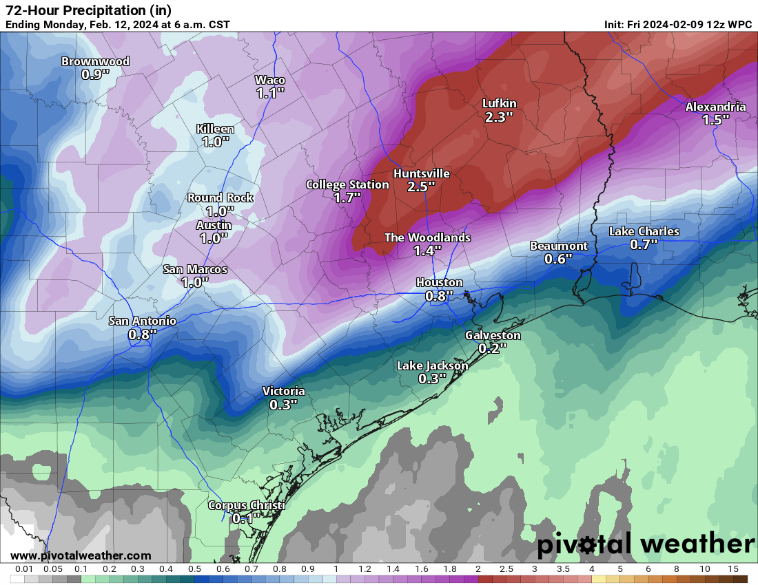
The areas that see the mostly stationary line of rainfall will probably see on the order of 1 to 3 inches. Those outside of that will see varying amounts from a quarter to half-inch or so. Look for a sharp gradient between the have-lots and have-nots. Flooding should be mostly just ponding and the usual trouble spots seeing water. Still, be careful if you are driving north and west of Downtown on Saturday.
Aside from rainfall, Saturday should be a mild day with temperatures in the 60s under the rain and low-70s away from the dreariness.
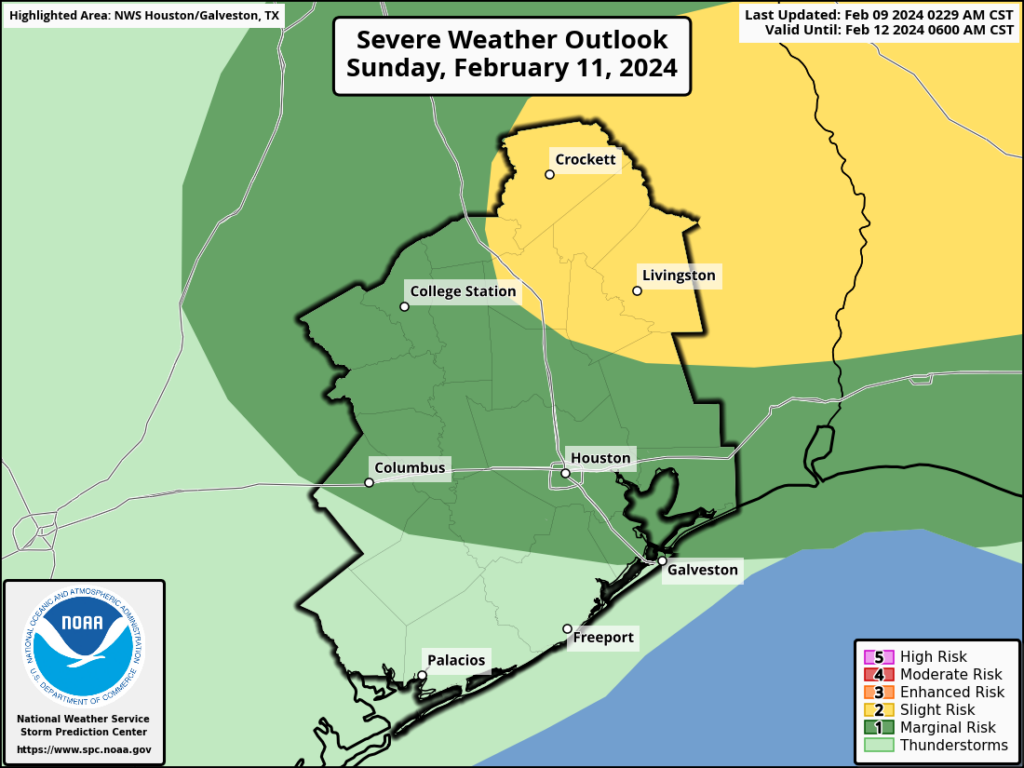
Some stronger thunderstorms are possible later Saturday and into Sunday, primarily well north of Houston, where a slight risk (level 2/5) is in place for Huntsville, Lake Livingston, and Lufkin. (NOAA)
Sunday
Additional rain or showers will skirt the area on Sunday. Most of this is expected to remain to the north of the Houston metro, so think like College Station through Huntsville or out toward Lufkin. Some thunderstorms embedded in that rain could be strong, and a slight risk (level 2/5) for severe weather exists for Huntsville, Lake Livingston, and Lufkin. Amounts of rain should be more modest Sunday with perhaps up to an inch or so under the heaviest rain and a half-inch or less in most other places. It’s possible that Houston and points south of I-10 see little to nothing on Sunday. Most places should start in the 60s and get one final day in the 70s before next week’s cooler weather.
Monday
After several warmer days this week and weekend, Monday will be a bit of a stark change. We should see a good deal of sunshine Monday, but with a chilly, gusty northwest wind pulling down cooler air, we’ll only top off in the mid-50s after a morning in the 40s.
Tuesday through Thursday
Temperatures will bounce back into the 60s on Tuesday and perhaps upper 60s by Wednesday or Thursday. Morning lows will be in the 30s and 40s Tuesday, 40s Wednesday, and 50s Thursday. No meaningful weather is expected, and we’ll probably a mix of sun and clouds most days.
Beyond Thursday
At this point I think Friday will be quiet, but there is growing potential for another decent rainmaker next weekend. Yes, confidence in another wet weekend is increasing.
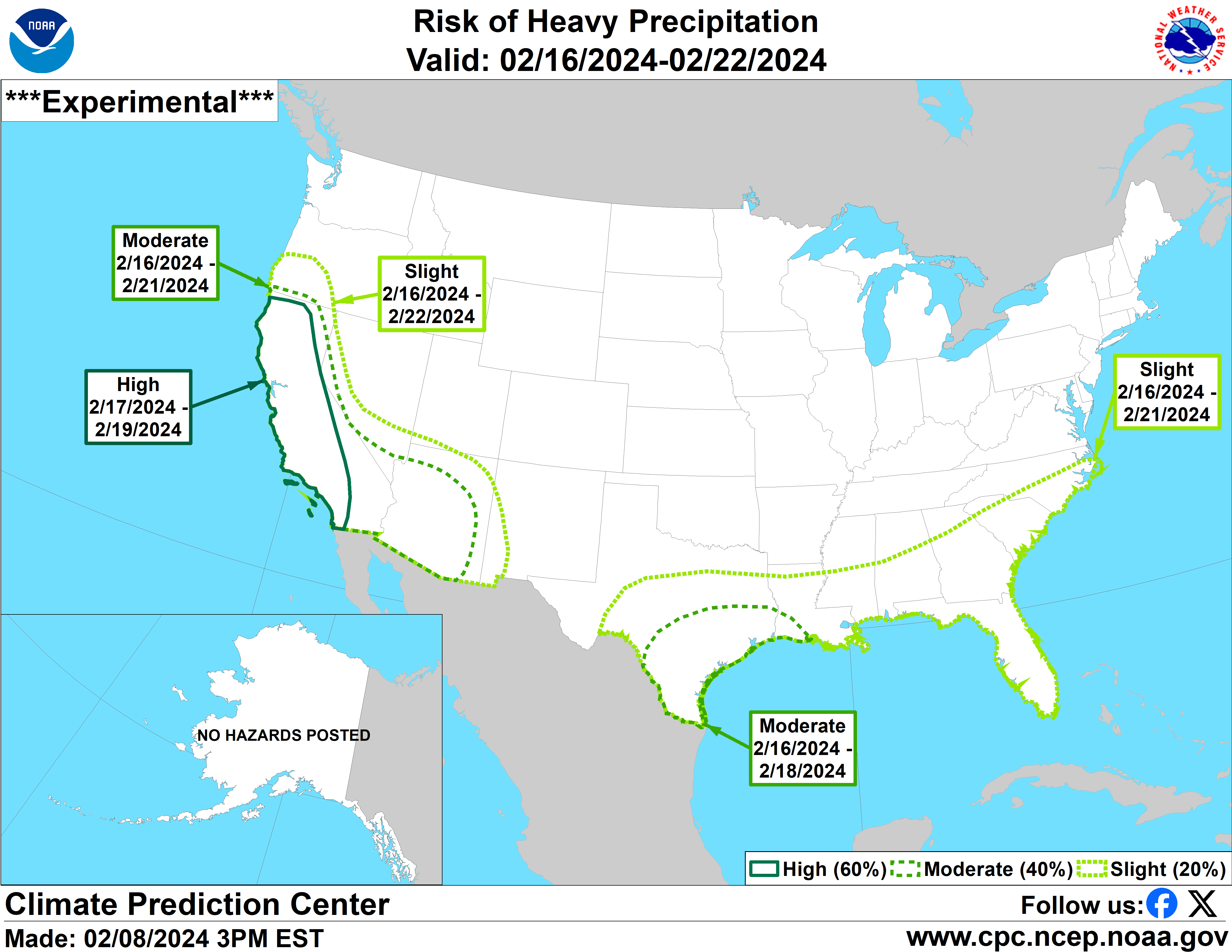
Our region has been highlighted by the Climate Prediction Center for potentially heavy rain next weekend. (NOAA)
When we’re forecasting this far out, particularly with respect to rainfall, we’re just looking for signals, not specifics. But the signal for next weekend has been consistent for the last few days in suggesting rain. We’ll see how that evolves over the next few days. But if you have plans next Saturday or Sunday, I invite you to lodge a formal protest with Eric. We’ll have more on those chances Monday.