In brief: After the hottest day of 2026 in Houston, we expect a quiet, less hot but more humid weekend. Rain chances then pick up next week with potentially locally heavy rainfall in spots by midweek.
Yesterday was our hottest day of the year in Houston, as we officially hit 91 degrees at Bush Airport. Lest anyone wonder if IAH is too overcooked, a CenterPoint sensor adjacent to the airport hit 90 degrees, so the answer is probably not. Hobby Airport also hit 91 degrees. That’s our 5th 90 degree day of the year. Early summer is here.
Today
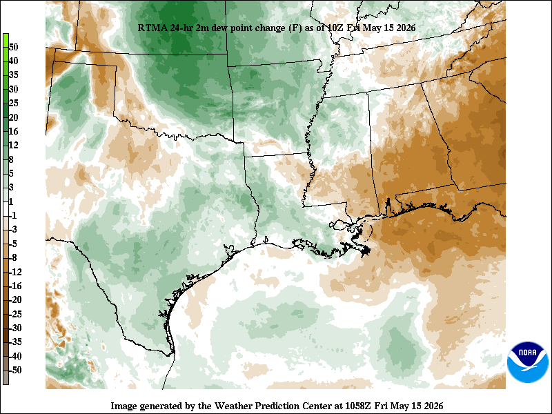
We have a shot at pushing 91 again today, though I think we may come up just a tinge short. Dewpoints and thus humidity are a bit higher today.
Dewpoints have increased a little bit in the last 24 hours, meaning temperatures may not be as hot as yesterday, but it’ll be close. (NOAA)
We also have a few extra clouds streaming through the area today. Either way, we are quibbling. It should feel fairly similar today to yesterday.
Weekend
Saturday looks fine. Sunday could see an isolated shower but nothing that would significantly disrupt your plans. You will notice the breeze this weekend. Onshore winds around 15 to 20 mph with gusts as high as 30 mph are possible on both weekend days as more humid air continues to rush ashore. High temperatures will probably come up short of 90 degrees, with mostly upper-80s expected. Cloud cover will be noticeable on both days, along with breaks of sunshine.
Next week
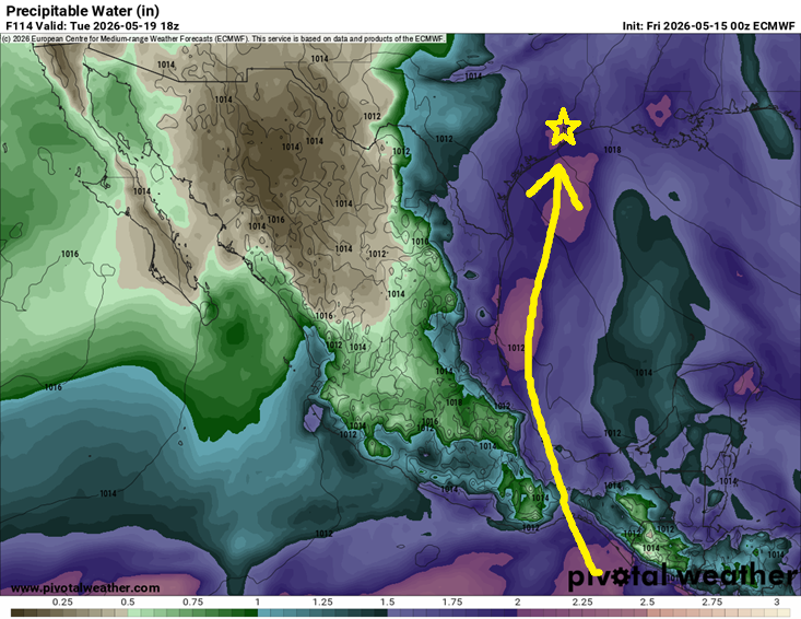
Expect a more active weather week next week. A pretty substantial plume of moisture in the atmosphere is going to extend from Texas, across the western Gulf, and into Central America. Some of this moisture plume actually extends back into the eastern Pacific too. So, we will have plentiful moisture in place to support potentially heavy rainfall in spots.
The moisture will be there next week, but where will the triggering end up? (Pivotal Weather)
The question we can’t answer this far out is where the triggering will end up. Will it be mainly in interior Texas? Louisiana? Here in Southeast Texas? We don’t know just yet, but there are plenty of signals in the modeling that 1 to 2 inches of rain or more will fall next week across the region. Isolated higher amounts would be almost guaranteed in this type of pattern. Bottom line: It’s too early to say exactly who will see the most rain next week, but there is an increasing chance that some parts of the area will receive locally heavy rainfall, especially next Tuesday or Wednesday. More to come on this.
The rain will hold back daytime temperatures a good bit, with highs mainly in the 80s but the moisture and clouds will hold lows in the mid to upper-70s. May the foggy glasses when you step out of the car commence.
In brief: Today should be the hottest day of the next week or so in Houston, with low 90s possible. Then, as humidity and clouds pick up some, we’ll see warmer mornings and slightly lower daytime highs. Rain chances pick back up on Monday. Plus, a special honor for SCW in today’s post!
Special thank you
Eric and I want to extend a special thank you to the City of Houston and specifically Council Member Abbie Kamin for honoring Space City Weather during yesterday’s City Council meeting with a proclamation recognizing our work. I (Matt) also want to extend a special thank you for a separate recognition on the occasion of my departure from Houston this summer.
Eric, Council Member Abbie Kamin, Matt very grateful on Wednesday!
This remains bittersweet for me personally, but I think I can speak for Eric when I say that we are grateful for the recognition. We’d be remiss not to also recognize Lee Hutchinson who has been critical to making sure the site stays up and running day in and day out, Dwight Silverman who has been an idea factory, mentor, and a big part of helping us manage our app, and Hussain Abbasi who actually built, maintains, and upgrades the Space City Weather app. It takes a village as they say, and that’s a huge part of our village.
We do what we do because we love our community and we love weather. And by some twist of fate, hard work, trust, and you, our readers, Space City Weather has become what it is. And the mission continues. Thank you again for the honor yesterday.
The quick and dirty
As Eric noted yesterday, the weather is very toasty and quiet right now, so there’s not a whole lot to say about the next few days. Expect sun, clouds, highs near 90, and increasing humidity. Today will probably be the hottest day of the next week, with perhaps a 91 or 92 being achieved. Then we shift toward more of an 88 to 90 type day/70-75 type night pattern into the weekend as a few extra clouds show up. We may see some added haze as well.
(NWS Houston)
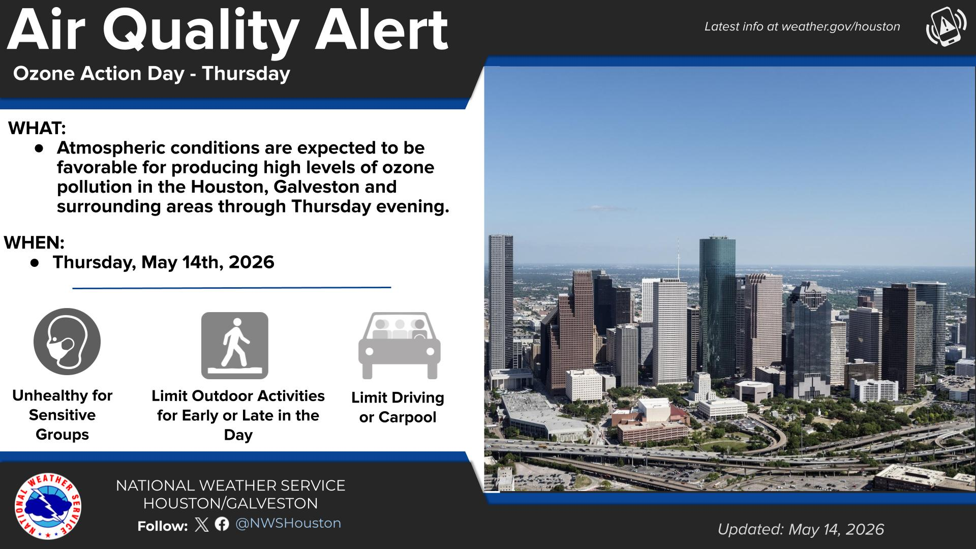
There is an air quality alert for ozone again today. When you get sunshine like we have ongoing, it tends to lead to a chemical reaction with pollutants near the ground to produce ground ozone. That will be our issue today, so if you have respiratory ailments, take it easy today, especially in the mid-morning and late afternoon.
What’s next?
Our next real rain chance is probably not until Monday, though we can’t entirely rule out a shower on Sunday or Sunday night either. Then we should settle into a more unsettled pattern next week with highs near or below normal (80s) and morning lows near or above normal (70s). Storm chances may peak Wednesday or Thursday but never completely shut off. More on this tomorrow.
In brief: Periods of heavy rain will track through Houston throughout the day today, especially along and north of I-10. Additionally, some strong to severe storms are possible this afternoon across the southern 2/3 of the area. Street flooding is a good bet today. Rain ends this evening with gusty winds overnight. But a stellar weekend awaits.
Today
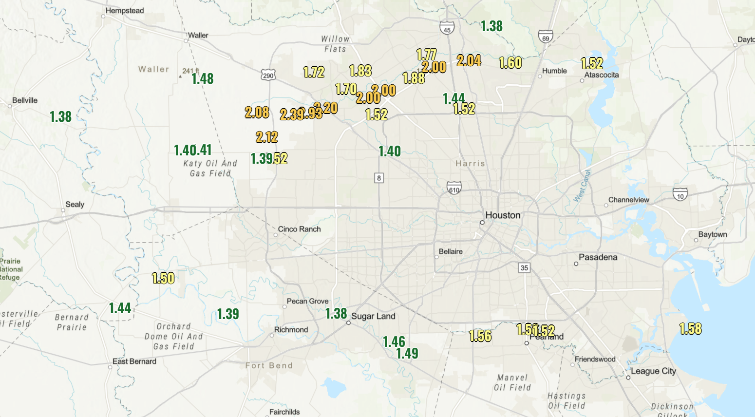
So far this morning, heavy rainfall has been limited to the northern half of the Houston metro, this after some strong storms overnight brought numerous hail reports from Sugar Land through Missouri City and Pearland.
Notable rain totals of around 1.5 inches or more since yesterday, as of 5 AM. (NOAA)
Areas between Cypress and Spring have seen 2 to 3 inches of rain since yesterday. The area that saw hail also received close to 1.5 inches of rain in many spots. Rain continues to jet along and north of Highway 59/I-69 in and west of Houston this morning and north of I-10 east of Houston. That’s going to be the general pattern for most of the day, where those areas see fairly persistent rainfall.
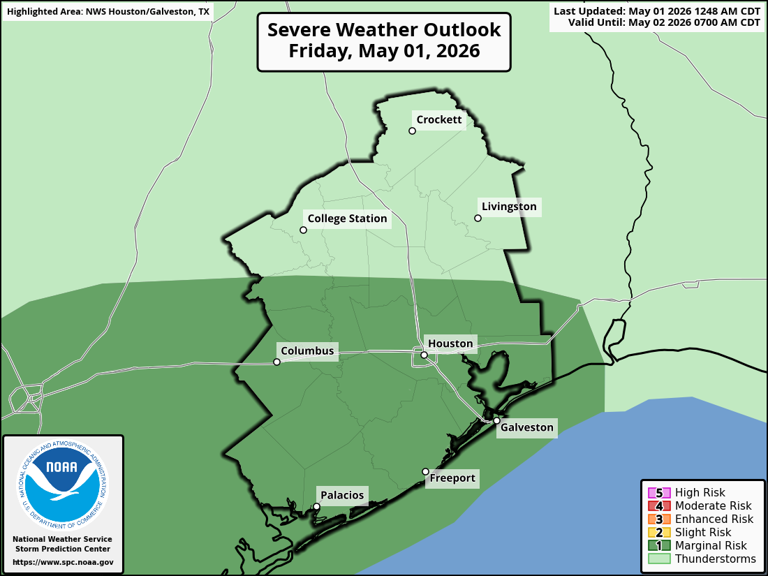
Severe weather risk
However, as we get into the late morning and afternoon hours, there will likely be at least a couple of more ambitious clusters of thunderstorms that develop south of those areas. This would be primarily along and south of I-10 across the Houston metro all the way down to the coast. Not to say we could not see a couple of these find their way north of the I-10 corridor into Liberty, Waller, or northern Harris County, but the severe weather focus today will be mostly south of there. Again, I-10 is not a magical barrier; it’s just a nice, easy demarcation line that most readers generally know.
As these storms wiggle through, any of them will be capable of producing 40 to 50 mph wind gusts, some large hail, and frequent lightning. As you get closer to, say, Freeport, Lake Jackson, Matagorda Bay, or as far south as Corpus Christi, there is also a little bit of “spin” in the atmosphere that could yield a storm that produces a tornado, so just be aware of that. The entire southern two-thirds of the area is in a marginal risk (level 1/5) primarily due to the hail risk, but also due to the wind and very isolated tornado risk.
The SPC has the southern 2/3 of the area in a marginal risk (1/5) for severe storms today. (NOAA SPC)
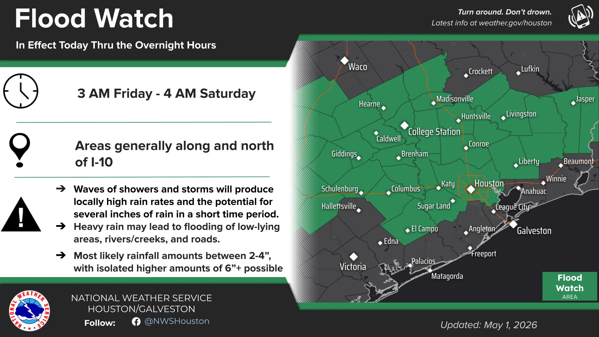
Flooding risks
In terms of how much additional rain we see, the entire area away from the coast is under a Flood Watch from the National Weather Service in Houston, a slight risk (level 2/4) for excessive rainfall from the NWS’s Weather Prediction Center, and a Stage 1 Flood Alert here on Space City Weather.
(NWS Houston)
What does that tell you? Street flooding is probably a good bet today. This is a good day to be weather aware if you have errands to run or appointments to tend to. Give yourself extra time to get where you need to go. This will be especially true in the second half of the day as the ground will be saturated, making some street flooding more likely.
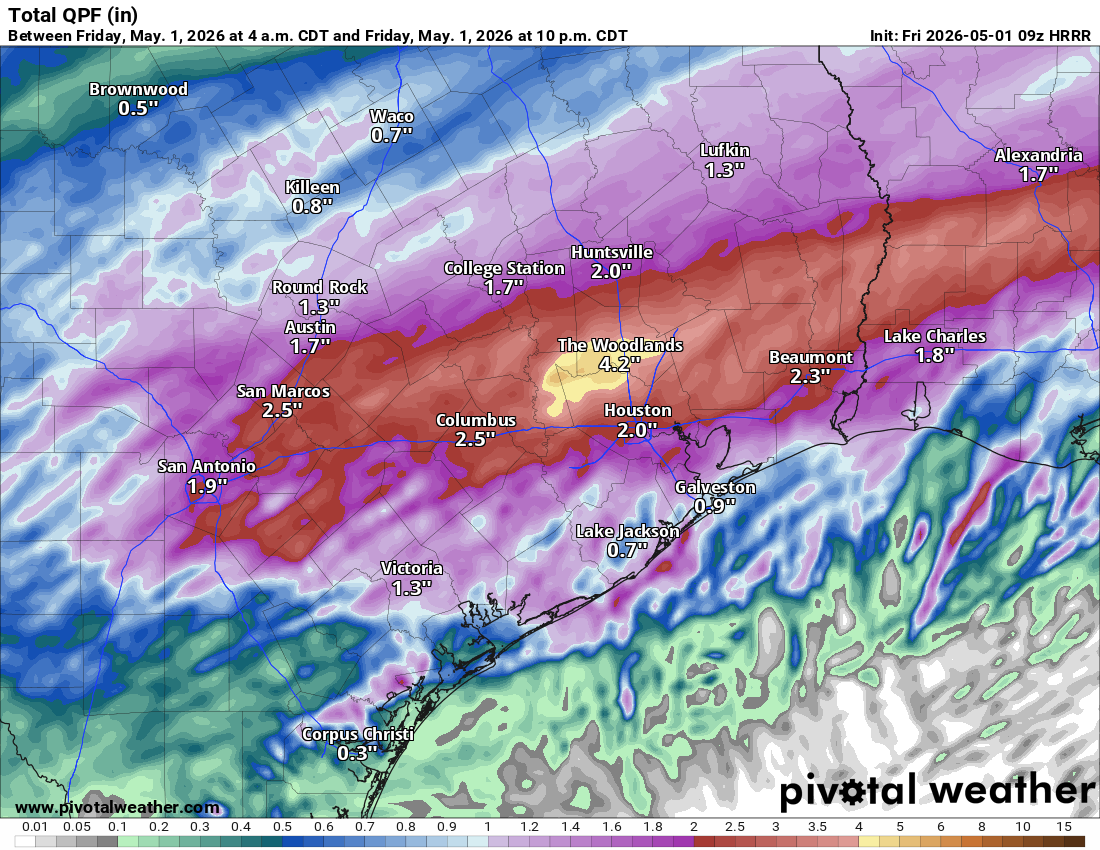
How much additional rain should we expect? It will vary, but likely another 1 to 4 inches of rain through the duration of the event where it’s currently raining (as of 5:30 AM). South of those areas should see anywhere from a half-inch to 2 inches of rain depending on exactly how this afternoon’s thunderstorms align. The latest HRRR model’s depiction of additional rainfall through this evening is shown below. Don’t focus on specifics here, but you can see the general pattern of how things should flow.
HRRR model depiction of additional rainfall today. Don’t focus on specific numbers here, but it should be on the order of 1 to 4 inches north and 0.5 to 2 inches south, with locally higher (and perhaps some lower) amounts likely. (Pivotal Weather)
The good news is that rain should be out of here tonight, so expect the rain to end from west to east from about 8 PM through 1 AM or so. Early evening plans will be dicey, but late evening plans may be ok. Just don’t drive through any residual flooded roads!
Eric will have another update on today’s weather situation by the afternoon.
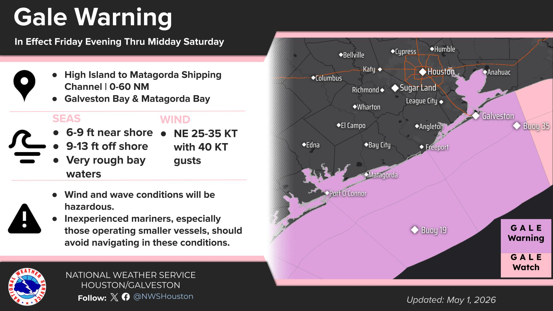
Gusty winds
One last note: As the rain begins to wind down, and the front pushes through with the disturbance kind of wound up, we are going to see non-thunderstorm winds increase. This should be especially true near the coast and in the southern half of the area. Inland wind gusts should be on the order of 20 to 30 mph beginning after 6 PM. Some locally higher gusts are possible. Coastal wind gusts will be more like 35 to 45 mph, and gale warnings are posted for the bays and Gulf.
(NWS Houston)
Winds should be at their gustiest from about midnight through 7 AM Saturday. Then, you’ll see them gradually subside through the day tomorrow.
Weekend
Other than the wind in the morning, tomorrow looks glorious with low humidity, sunshine, and highs in the mid-70s. Overnight lows will be in the 50s. Sunday looks just as nice or better with more sun and highs in the upper 70s to near 80 degrees. Enjoy the early May, comfortable weekend spring fling!
Next week
Looking ahead, temperatures do warm up a good bit, back close to 90 degrees by the time we get to Tuesday or Wednesday. Believe it or not, another May cold front may be in the cards for later next week. Details forthcoming on that, but additional rain and storm chances may be in the cards around then as well.
In brief: Houston firmly ramps into pre-summer this weekend with several chances at 90 degree highs between Saturday and Tuesday. Lower-end chances for a couple feisty thunderstorms exist today and perhaps around midweek next week before we eye a possible cooldown next weekend.
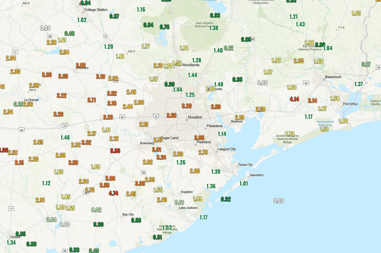
Pre-summer will be enroute to the Houston area over the next several days. That said, we’ve finally gotten some rain here. In fact, over the last 10 days, most of the area has seen anywhere from 1 to 5 inches of rainfall. Soil moisture has not entirely caught up to where it should be for this time of year, but it has improved vastly this month.
A sampling of observed rainfall totals over the last 10 days. (NOAA)
While we heat up, we will also be dodging some rain chances here and there.
Today
The area is highlighted in a marginal risk (level 1/5) for severe storms today, as there will be a very slight chance for a couple pop up storms later this afternoon. The highest chance for a couple storms would be north of I-10 and east of I-45, but with a springtime air mass, some sunshine, and instability, it’s not out of the question that a couple storms pop up outside of that quadrant of the area. Most of us will remain dry though. Highs will be in the mid to locally upper 80s today.
There may also be a couple more organized storms late this evening in Louisiana that drop north to south and could graze locations east of I-45 as well, though probably closer to Lufkin and Beaumont than Houston.
Weekend
The weekend should be mostly dry, but we cannot entirely rule out a pop-up shower or very rogue thunderstorm. Otherwise, it’ll be spring swampy with highs well into the 80s to perhaps near 90 degrees and plentiful humidity. Winds from the south at 10 to 15 mph will be what you get for the MS 150 ride this weekend. Some higher gusts over 20 mph are possible, especially in open area or on hill crests. Good luck to all the participants.
Monday & Tuesday
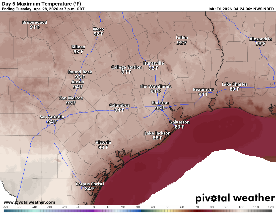
These should be our hottest days. While most forecast highs are into the low-90s right now, I would not be shocked if recent rains and some model tendency to get overeager lead us to see temperatures closer than 89 to 91 degrees here rather than 92 to 94 degrees. We shall see.
Tuesday’s forecast highs are well into the low-90s right now. (Pivotal Weather)
Other than the slightest of chances of a shower or storm with daytime heating, it looks just plain ole hot and humid. By Tuesday evening there may be a better organized line of storms dropping south from Dallas, but I currently expect it to fizzle out before getting here. Probably not an issue, but we’ll keep watch.
Later next week
Wednesday and Thursday should also be hot days with upper 80s to 90 or so. However, there is a chance of showers or a thunderstorm on those days, a slightly better chance. This may be a precursor to what could be a fairly strong cold front at the end of the week. The front may (should?) allow for us to have another refreshing series of days next weekend.
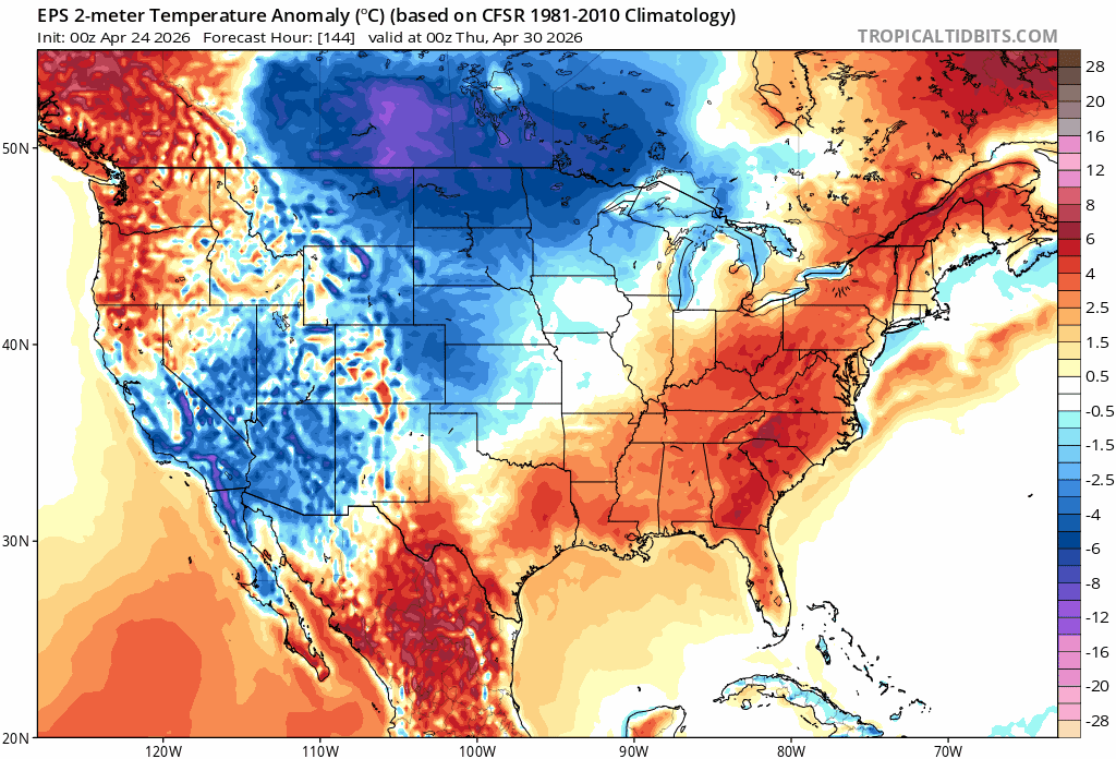
Temperature anomalies as forecast by the Euro ensemble from Wednesday evening through Saturday morning next week showing a plunge of much cooler air by the weekend into Texas. (Tropical Tidbits)
The signal in modeling is pretty stout, so I’m cautiously favoring a noteworthy cooldown next weekend. More on that Monday.