Good morning! We are in store for a delightful weekend of weather here in Houston, so I want to touch on a couple items before we get into the forecast details: Hurricane season & drought.
Changes coming to the 2021 hurricane season
The World Meteorological Organization (WMO) met this week, as they do each year to discuss hurricane names that should be retired, among other items. If you have not yet heard, some newsworthy items came out of that meeting.
First off, several storm names were retired. Since they didn’t meet due to the pandemic last year, both 2019 and 2020 were addressed this year. For 2019, the only retiree was Hurricane Dorian, which devastated the Bahamas in particular. Tropical Storm Imelda, which killed 6 and caused roughly $5 billion in damage as a storm many across Southeast Texas won’t soon forget was not retired. Imelda will appear again in 2025. For 2020, Hurricane Laura was retired. Hurricanes Eta and Iota, which both devastated Nicaragua were also retired. For those curious, Dexter will replace Dorian in 2025 and Leah will replace Laura in 2026.
In addition, the Greek alphabet was retired. No, really. The WMO agreed that if a season’s name list was exhausted, shifting to a list of Greek letters was too confusing. So they now have what amounts to an auxiliary list of storm names that will be utilized in the event we use all the names on the primary list for that season.
I believe that if one of those names is retired, it will just disappear and be replaced like any other season. Previously, they could not retire Greek letters.
Thoughts: Matt’s opinion here, but I’m not entirely surprised Imelda was not retired. That doesn’t necessarily make it right, as I feel Imelda coming sort of on the heels of Harvey makes it a special case for a highly populated, if small-ish area of impact. Claudette in 1979, which flooded Alvin terribly was never retired either. So there is certainly precedent, but again, if it were Matt’s decision, retiring Imelda would kind of be like having Harold Baines in the Baseball Hall of Fame. There’s a case one could make there, even if it is very, very borderline. As far as the Greek letters being canned? I like it a lot. I think this is absolutely the right decision, and it will create much less confusion and distraction, should we get there again.
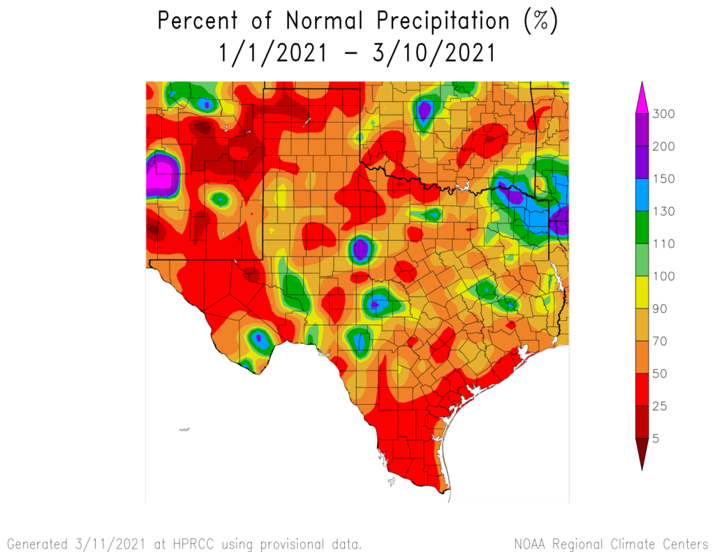
Drought worsening
The Drought Monitor was updated yesterday, and although Wednesday’s rain is not included in this calculation, drought did worsen across both Texas as a whole and locally in the Houston area.
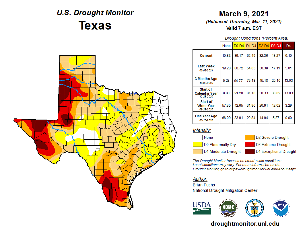

The only part of Texas not really seeing drought get worse is the El Paso area and far west, as drought is already pretty bad there. The Greater Houston area went from about 35 percent of the region in drought last week to almost 60 percent this week. NOAA’s outlook for the next few months suggests drought will maintain or worsen across Texas.
As we’ve noted, this is a story we will continue to follow.
Today & weekend
We will close out the week on a cool but sunny note. There are some high clouds that could drop in from the north today, but short of that, expect sunshine and 60s this afternoon with a bit less wind than yesterday. Saturday should be similar with mainly sunshine but at least some chance of high clouds at times. We’ll start in the 40s in most places tomorrow, warming into the 60s, with areas south and west of Houston pushing back near 70 degrees.
Our winds will shift onshore on Sunday, with warmer, more humid air beginning to gradually filter in off the Gulf. Look for morning lows in the 40s and low-50s and highs in the upper-60s to low-70s and a good bit of sunshine once again.
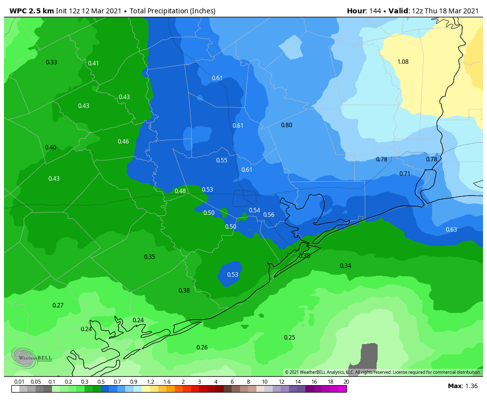
Next week
A pair of upper level systems will move into the region, with the first arriving later Monday and Tuesday and another later in the week. These will each help drive a cold front into the Houston area, along with a chance of showers and storms. As is often the case this time of year, there are questions as to how far offshore the fronts will get or if they (particularly the first one) will fall apart over us. Either way, look for a somewhat unsettled week next week with a couple days of rain chances and generally warm temperatures. We should see a final front push well off to our east and somewhat cooler weather arrive by later in the week or next weekend. We will have finer details for you on Monday.