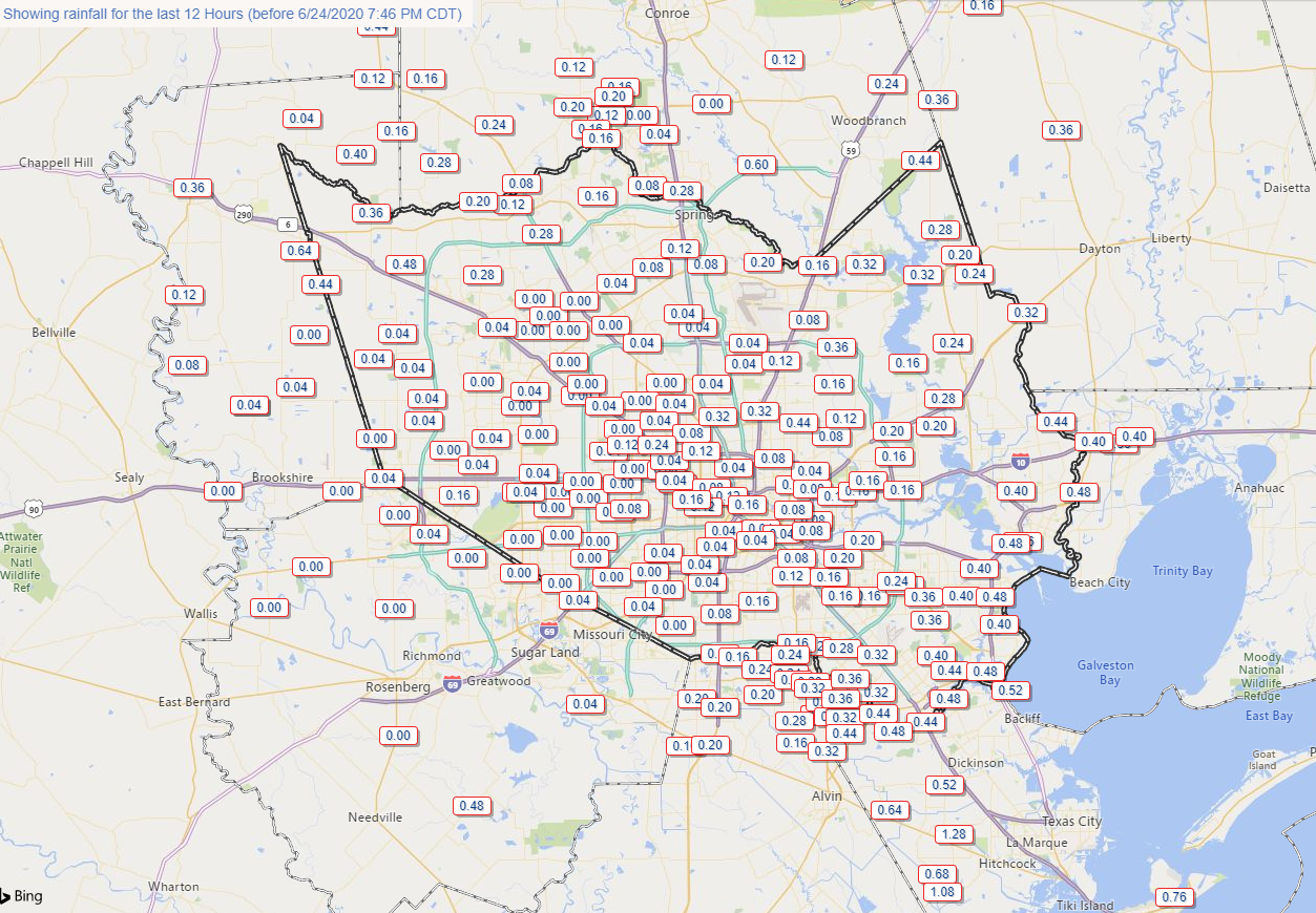
Today ended up being a mostly quiet one again for most of the region, with just a few showers here and there. Rainfall since about 7 AM today has been more than manageable with most areas seeing minor amounts. A couple areas, notably up toward Conroe and south toward Santa Fe and Galveston have seen close to or in excess of an inch of rain since 7 AM today.
So we’ve done alright so far. Heading into tonight, I will level with you: Eric and I are scratching our heads a bit. Yesterday, it appeared we had a pretty favorable setup for heavy rain leading into the nighttime, and yes it materialized, but not in the way we were anticipating until late in the game. Tonight we are presented with a set of data that is different than yesterday but does offer up some risk of heavier rainfall in spots.
Brace yourselves, some serious nerd-speak is coming in this paragraph: I just dug through a lot of the meteorology here, and what I’m coming up with does make me think some areas could see some locally heavy rainfall tonight. For one, we have a weak upper level low over Southeast Texas. Those are notoriously fickle systems, and they can become more active at night. Second, it appears there is some sort of weak boundary at the surface that’s roughly along US-59/I-69 from Victoria through Houston that then arcs to the east toward Beaumont. Boundaries like this can act as focusing points for thunderstorms. Third, model parameters suggest a good bit of instability in the atmosphere tonight. Higher instability means thunderstorms can develop and sustain themselves. Fourth, models suggest plenty of atmospheric moisture is available right now. Observations back this up, as the weather balloon launched at 7 PM from Lake Charles shows precipitable water values in the 90th percentile for this time of year, which means if storms can get going, they can rain heavily. Lastly, it appears that winds about 5,000 feet above the surface are going to increase off the Gulf from south to north tonight, aimed east of Houston. Winds at that level can act to provide additional ingredients and moisture needed for heavy rainfall.
This is a long winded way of saying that the meteorology that’s showing up right now backs up the idea that we could see some heavy rainfall tonight.
The question, as always, is can the ingredients actually come together in such a way to allow this to transpire. I really don’t know. These are fickle, tricky situations, so there’s always a chance a few things don’t happen and you end up with a couple isolated showers and storms and that’s that. But, if things do come together, we could be talking about repetitive showers and storms for some areas.
So, for most of the area tonight, let’s just call it a few showers or a storm possible. Some folks will see nothing. Others some heavy rain for a time. Totals of a quarter inch to an inch.
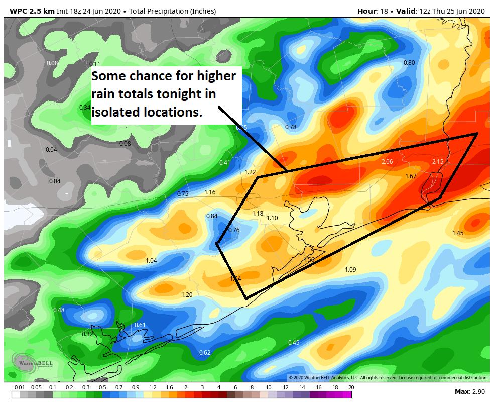
Put a pin over downtown Houston and if you go south of there and east of there, you stand the chance of seeing perhaps some more sustained rainfall. In those places, I would say your odds of seeing a quarter inch to inch of rain are higher than northwest of Houston. There may also be a few isolated locations that see as much as 2 to 4 inches of rain or a bit more in a worst case scenario. The odds of that happening are not high, but as I laid out above, the ingredients are certainly in place. If I had to focus on an area tonight for the highest risk of this it would be from Baytown to Beaumont.
Anyway, we just wanted to provide some situational awareness for you this evening. Be safe!

What can we expect from the dust storm headed our way? Should we stay inside?
Eric will have more in the morning. Air quality will be moderately bad to unhealthy for sensitive groups. If you fall into the latter category, it makes sense to stay indoors as much as possible, mainly from late tomorrow through Saturday morning. It should improve Saturday afternoon I think. But again, Eric will have more in the morning.
Y’all are so cool. I really appreciate your updates!
Thanks, Matt, for your update on tonight’s forecast. I’m guessing if you are anything like my husband, you think of your work as a hobby. I appreciate you and Eric so much!
i was literally just going to say the SAME thing. they’re the only ones i head to when looking for information regarding weather. i’ll be a #1 fan forever, great job guys!
Thanks Matt…a lot of work, thought went into your posting…end result is you guys provide data-supported info to your subscribers…ZERO HYPE…I’m one, obviously with many more, that greatly appreciates this approach…it is most comforting…thank you…
I noticed on the satellite photo of the Gulf of Mexico, a large plume of moisture in the Bay of Campeche. Is there anything to this?
Wow! At 4:30 this morning, violent storms in Spring. They appear to be training right over us.
Violent storms here in North Katy as well. They’ve been at it for hours now.