The National Hurricane Center upgraded Invest 91L in the Gulf to Potential Tropical Cyclone 9 this morning, and since its potential has been realized, it is now Tropical Depression 9. Despite these changes, which were mostly expected, not much has changed from our morning post in terms of expected impacts in Texas and Mexico. Locally in Houston, we expect to see little more than an easterly breeze, a few more clouds, and sporadic showers today and Tuesday. The action is going to be down the coast.
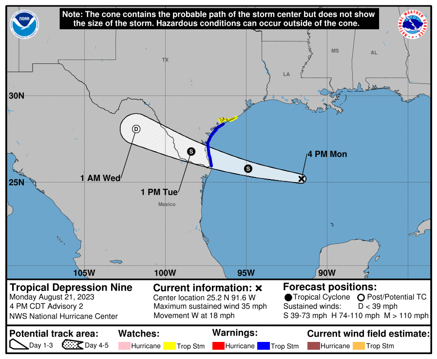
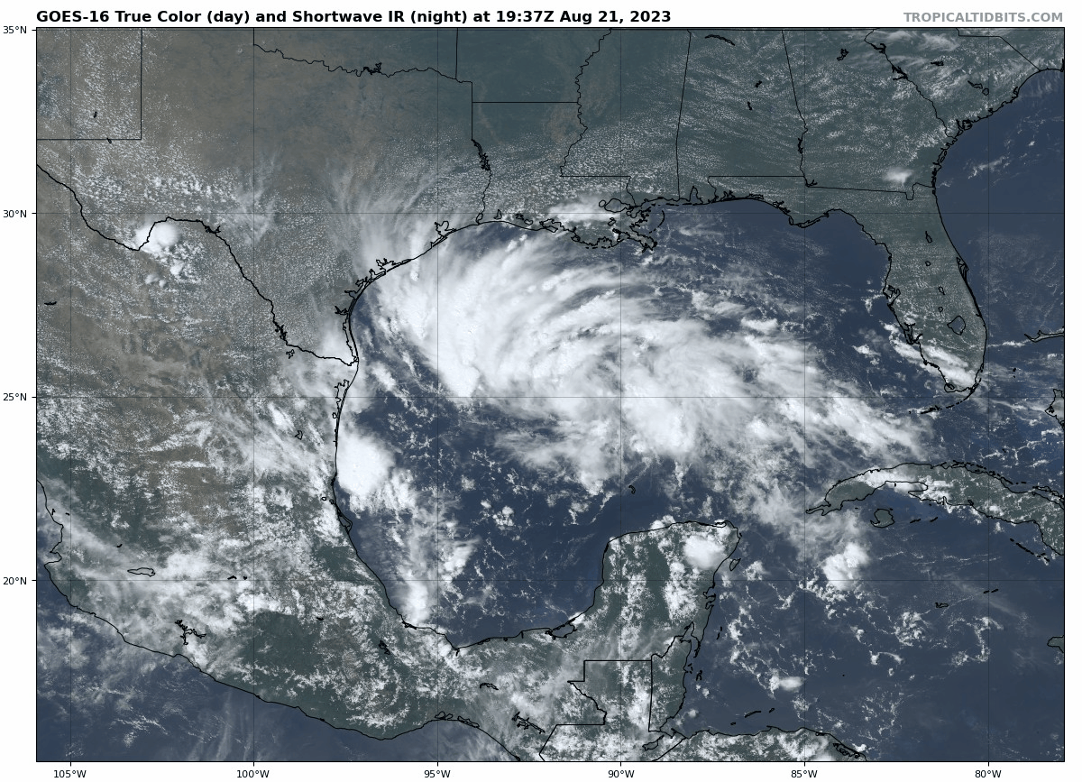
Tropical Storm Warnings are posted along the Texas coast from the Rio Grande River north past Corpus Christi to Port O’Connor. A Tropical Storm Watch extends north from there to Sargent, TX. Looking at TD 9 on satellite this afternoon shows a whole lot of storms. I said it this morning, and I’ll say it again. We are fortunate that this thing has a limited amount of time left over water.
It has all the ingredients you need in place to blow up into a big storm, except the most critical thing: time. The depression is racing west at 18 miles per hour, which means it will be ashore in Texas by Tuesday morning. Impacts will be minor to moderate in South Texas, with the potential for some gusty winds to tropical storm force, mainly south of Corpus Christi and offshore. Meanwhile, beneficial rain will fall in South Texas, where generally 1 to 3 inches will fall. There will likely be a few pockets of 4 to 5 inches in Brush Country and more into the mountains of Mexico.
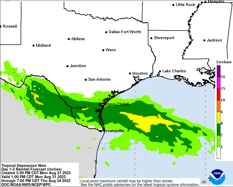
Rainfall impacts will be minimal north of there, with Houston and San Antonio mostly missing out on anything. In fact, with a bit of a breeze in between the heat ridge to our north and TD 9 to our south, we may have a slightly enhanced risk of fire danger in parts of Texas again on Tuesday. When it fails, it fails hard.
In addition to heavy rain in South Texas, there is also a chance for isolated tornadoes, as is often the case with landfalling tropical systems. But the main issue to impact your daily life in that area will be heavy rain.
By Wednesday, TD 9 or Harold will make its way across Mexico, and a piece of its remnants may actually find its way into the monsoon flow in New Mexico and Arizona, which would bring some beneficial rain to those areas that mostly missed out on Hilary’s rainfall this past weekend. Rare is the tropical system that is mostly a net positive, but this one may very well be just that. We’ll keep an eye on rain totals tomorrow to make sure things stay under control.


So depressing… the one time we would welcome a TS and it misses us.
On the upside, the cloud cover this afternoon has already provided some relief from the heat. Short-lived as it may be, at this point anything helps.
Crap!
Most of us are thinking something a little stronger….
Man the sprinklers……again.
And root feeders…. save your trees!
Hopefully it hits RGV we need the rain direly!! It’s been too hot and dry for the past 5 summers! Hopefully we get this storm and snow in winter!!
Praying the storm does not harm you, family, and home. Living in Florida my entire life, mother nature can destroy all that you own. Please don’t take ANY storm warnings “lightly”. Take precautions. I still have Hurrican Ian damages. FEMA can’t always put your life back in order. Take care.
Hi Eric. Thanks for all you guys do. Is there any hope that these duo of storms (ours and the one over a California) can ‘break’ the high pressure system over us, or do they just not have enough horsepower to do that?
Thanks.