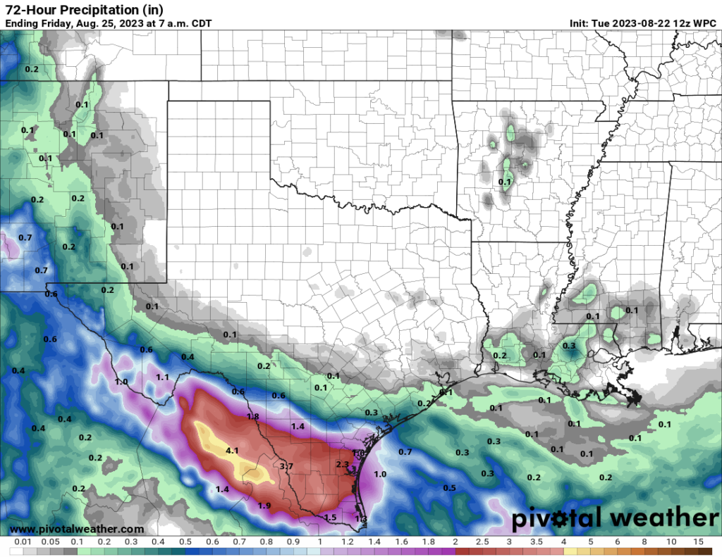
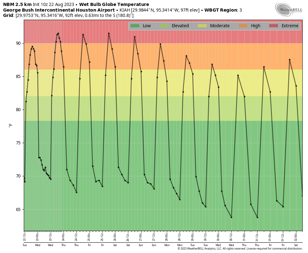
As we’ve been telling you since Friday, the tropical system in the Gulf of Mexico—which was upgraded to Tropical Storm Harold overnight—is going to go far enough south of the Houston metro region to preclude us from seeing significant effects. We’ll see some easterly breezes, with decent gusts, and we’ll see some clouds. But unfortunately we’re not going to the kind of significant, widespread rainfall needed to help put a dent in our sharpening drought. Instead, we just get more heat.
Please don’t kill the messenger.
Tuesday
Whether you see any effects from Harold will depend on how close you live to the coast. Residents of southern Brazoria and Galveston counties will have the best chances of rain, perhaps 50 percent today, and strongest winds. Gusts above 40 mph are possible today right along the coast. Areas further inland, but south of Interstate 10, will see lesser rain chances of around 30 percent, with slightly less gusty winds. Highs should be below 100 degrees for these areas relatively near the coast.
And parts of Houston north of Interstate 10? Well, it’s just going to be another very hot and mostly sunny day. Highs may reach the low- to mid-100s again for places such as The Woodlands. Rain chances for inland locations are perhaps 10 percent.
Wednesday
This will be a sunny day with highs in the low 100s across the area. With a bit of lingering moisture from Harold, rain chances are perhaps 10 or 20 percent.
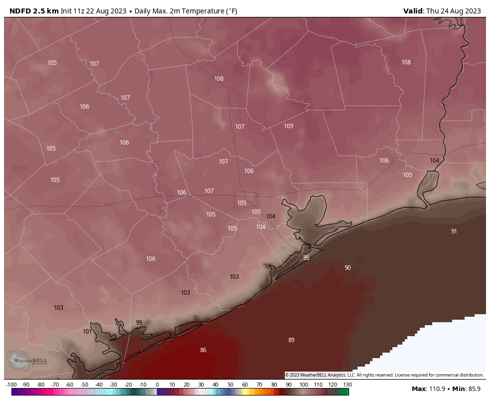
Thursday and Friday
These two days look really hot, with highs in the 105-degree range likely for much of the area. Skies will be mostly sunny. Rain chances are not zero, so perhaps 10 percent daily.
Saturday and Sunday
Don’t get me wrong, these will be hot and mostly sunny days. But as high pressure eases off to the West, highs may drop back down to around 100 degrees. We’ll also see some weak atmospheric disturbances that could spark some scattered showers during the afternoon hours. Please do not get too excited, as I’d peg rain chances at only about 20 percent.
Next week
If you had hot and mostly sunny on your bingo card for next week, congratulations, you’re a winner! However, I don’t think next week will be as hot as this one, and we’re also going to see some modest rain chances. I don’t think they’ll be higher than 20 or 30 percent each day, but that is a sight better than the 0 to 5 percent we’ve experienced for much of this summer. In case you’re wondering, we’re still about three to five weeks away from when we can anticipate our first decent cold front of the season. It can’t come soon enough, I know.
Tropics
Beyond Harold, which will bring some tropical winds and rains to South Texas, there is a lot happening out there in the Atlantic. While there are no distinct threats to the Gulf of Mexico, or Texas, that can change fairly quickly at this time of year. Be sure and check The Eyewall for a full rundown of all the activity out there, every morning around 7 am CT. Matt has been nerding out with some book-length posts of late.


Very windy since last night here in San Leon. Smells like rain. Better than nothing I guess.
The petrichor.
The talk of a cold front has me wondering–are we able to expect the “usual” sort of weak front in a 5 weeks or so, or are the old models being disintegrated as we watch?
The old models are continually being “disintegrated” in that models are updated as new data become available.
If reading SCW has taught us anything, it should be that weather has unpredictability to it. So to predict a front 5 weeks out would be nearly impossible. The uncertainty in the modes grows the further out they are asked to predict, so even the best models and the wisest of meteorologists will have very low certainty when asked to forecast that far into the future.
If you’re implying that the changing climate is making our current models less accurate, the answer is almost certainly yes, but that is to be expected and not something to worry too much about. The accuracy of the models will likely to continue to improve over time, as methods improve and computers become more powerful.
We live south of Alvin and woke up to a decent shower this morning, maybe 1/4″, but we’ll take anything we can get and be thankful.
Eric, what is it going to take to break up the heat dome? I just can’t imagine a cold front at this point.
The high pressure would need to move away from TX for a break to happen
I sincerely wish you would stop using the term “low- to mid-100s.” If temps reach 150 degrees, we’re all dead.
I thought the same thing!
Same here … 110* to 150* F ?
I don’t think so! 🙂
He’s speaking in ‘tens.’ Low to mid 80s (I wish), low to mid 90s…
You mean it hasn’t gotten to 150 yet?
Another great season is here. The raining season
“A single gentle rain makes the grass many shades greener.” — Henry David Thoreau
It does not look good and it looks like we missed our shot with this system but let’s stay positive. Next weeks 20-30 percent shot each day means two maybe three out of every ten yards will be a little “greener”!
I like the way you put those odds, Glenn. Way to find the silver lining!
Can you tell us when we will see rain again?
That’s obvious.
Never.
I wanna know, have you ever seen the rain? Coming down on a sunny day…
Someone please tell the Wakandans to take down the force field over Texas. The feds already told us there are aliens here already…
Received a very brief two minute rain this morning about 5:50AM in Hitchcock.
West Coast flooding, no wildfires and no more drought in California. So, if the cycle changed in California, it will definitely do so here. Hang in there.
Pretty soon some enterprising types are going to launch a new business – rain tourism, which will take visitors south to where ever the rain is so they can marvel at such a wonder.
I’ve been seeing ads for Southwest Airlines saying “cool weather for sale”.
For more historical perspective there is an article published on the Joplin Globe website by Brad Belk entitled “Recalling the superheated summer of 1954”. The article reports that for “[f]orty-five days the mercury indicated 100 degrees or better. Over 25 of those days, the mercury broke 105 degrees.” On July 14 the high temperature of 122° was recorded in Pittsburg, Kansas. Air conditioning was a rarity. People died.
….and in the West Coast that same ’54 summer season, they called it the year without a summer.
Shout out to you guys for finding different ways to say the same thing everyday. I’m gonna stay away from this blog for a few weeks, I’ll check back when temps are below 90 lol. I’m done dealing with this heat
See ‘ya this evening!
Missouri City, specifically Highway 6 and the Fort Bend Toll just had a nice 5 to 10 minute rain shower, pretty heavy.
TEXAS has 10 categories of active alerts on the National Weather Service map today! That must be a new record for us! All the other states have 0,1,2 or 3 ( except possibly California and the Hilary events). Our state map includes an excessive heat warning (no surprise), a heat advisory, red flag warning, tropical storm warning, wind advisory and related warnings around Beeville, and then my favorite…a huge flood watch out in West Texas! This beautiful hunter green colored watch includes Pecos, Big Bend National Park, Alpine, Marfa, the Davis Mountains, and a large swath of the Texas Chihuahuan Desert. I’ll watch the radar out west today and tomorrow to see the results. So sad that we missed out, but happy for our friends down in South Texas areas. Hope it’s our turn soon.
It’s raining!!!! in Montrose area. Hope it lasts!!
Rosenberg just had 15 to 20 minutes of hard rain at noon, maybe a half inch. Thoroughly wet my yard and ran the
gutters full. Note to self, do not press enter until ready to post.
This is all my fault. I have not washed my truck in over a month and guess what? I washed it today and no more than 20 minutes later we got a shower! About a 1/4″ in Friendswood. I should have washed my truck at least a month ago…
Our car was washed a couple days ago, but to no avail here!
The name retirement of Harvey has got to have done something that made this happen! Which part of Texas is next in 2029? Don’t tune in to find out just move north…
Around midday, in the Uptown area north of the Galleria, a sprinkling of rain.
I was going to accuse the people who offered you ice cream of all living in Corpus Christi. But then we got a few raindrops in Rosenberg.