Tropical Storm Barry is flirting with hurricane intensity this morning south of Morgan City, LA. Maximum sustained winds are 70 mph, and it’s possible Barry could cross the finish line as a hurricane. Landfall is expected somewhere on the west side of Vermilion Bay, LA this afternoon.
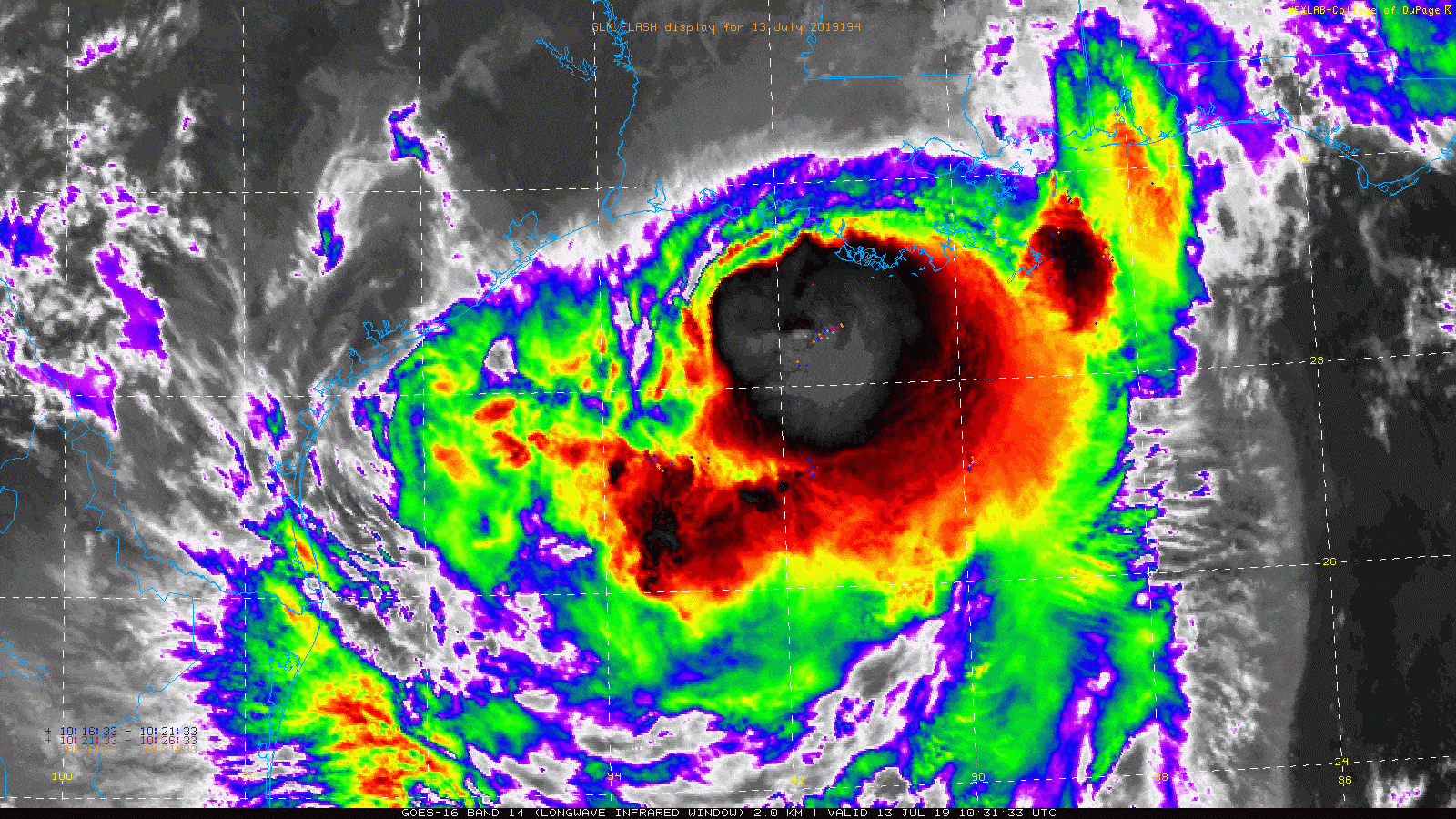
Moving forward, Barry will slowly move inland over Louisiana, and all those bright clouds that indicate thunderstorms are going to come ashore in Louisiana. It’s been mostly nuisance rain there so far, but it will escalate significant later today or tonight. Storm surge flooding is an ongoing issue across much of eastern Louisiana.
More than a dozen people stranded on rooftops in Terrebonne Parish are being rescued by the Coast Guard. https://t.co/t5cIy9rYXt
— NOLA.com (@NOLAnews) July 13, 2019
Significant storm #surge is pushing into the Atchafalaya basin south of Morgan City right now from #Barry. Winds gusting to 80 mph at the @noaaocean Eugene Island tide gauge with pressure down to 994 mb. #TropicalStormBarry #lawx pic.twitter.com/i7hDkJJ3k9
— Michael Lowry (@MichaelRLowry) July 13, 2019
We will continue to see these problems through the day, and then the rainfall will begin to cause problems tonight.
How much rain?
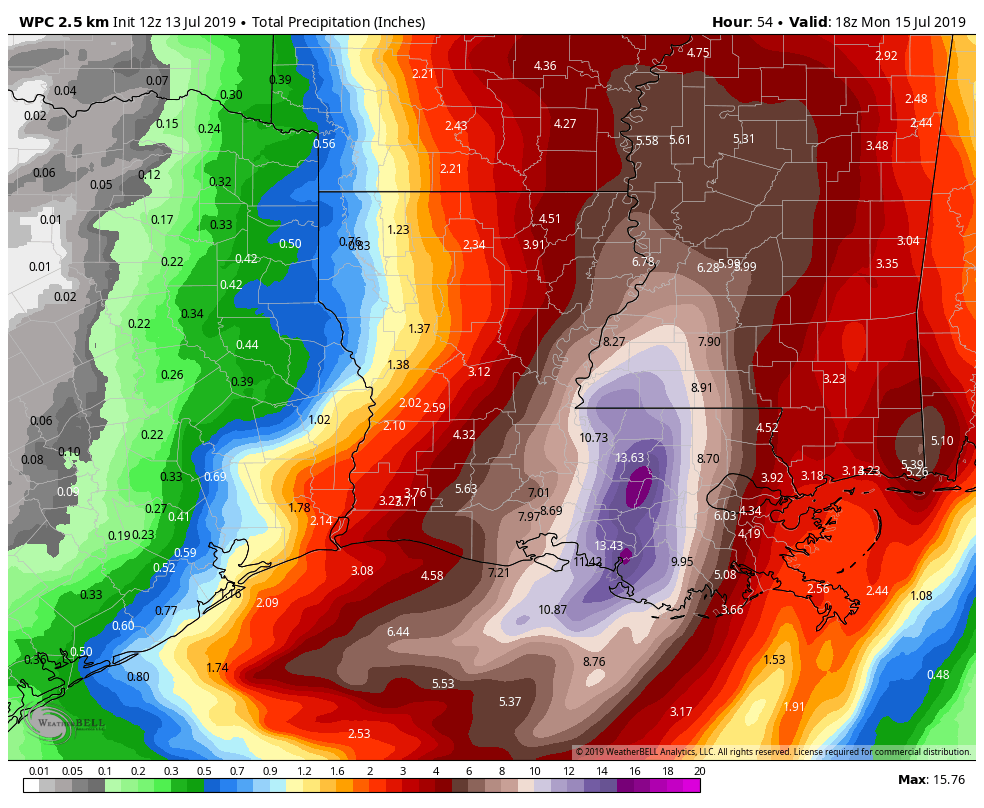
Well, according to the NWS Weather Prediction Center, most of eastern Louisiana should see four inches or more of rainfall, with the bullseye between Lafayette and New Orleans of 10 to 15 inches. This bullseye may end up near the Baton Rouge area.
This serves as a nice breakpoint for us to shift gears and talk about Texas. That official forecast shows 1 to 2 inches through Monday afternoon between Galveston and Beaumont, with lesser amounts north and west of there. Let’s break things down a bit.

Today
Expect a few showers and storms to develop this afternoon, mostly east of I-45. Not everyone will get rained on, however. Most rain will be quick moving, so in general no more than a quarter to half-inch is expected in any one location.
Tonight
While we can’t rule out a passing shower or gusty thunderstorm at any point tonight, the majority of the time looks quiet and dry. We may begin to see some development of showers along the coast late, or a feeder band into Barry as it lifts into Louisiana.
Sunday
With that developing band, expect to see showers and thunderstorms develop along the coast or just inland through the day, becoming more likely in the afternoon. It’s possible the bulk of the rain stays offshore, but there is a very reasonable chance it includes Galveston through Bolivar and 10 miles or so inland from there. If that occurs, expect numerous showers and thunderstorms Sunday morning into the afternoon. For Houston and points west and north, you would likely just see scattered downpours and thunderstorms tomorrow.
If you’re trying to plan outdoor time around this tomorrow, I would have a serious indoor alternative planned if I were in Galveston County or along the coast from Surfside Beach through Port Arthur. Inland from there, have a backup plan in mind, but you may only need it for a short time or intermittently.
Sunday night
If that feeder band sets up along the coast, expect waves of rain and thunderstorms Sunday evening, tapering toward Monday morning. Rain totals will be 1 to 2 inches in coastal areas on average, but if the band orients right along the coast or just inland and stays stationary, we could see as much as 3 to 5 inches and some areas of street flooding, especially in Galveston.
Monday and beyond
Look for scattered showers and storms across the area Monday as the day goes on with locally heavy downpours possible. By Tuesday, we begin to transition to a calmer pattern, so just a chance of storms. Wednesday and onward, expect just a few daily showers popping up along the sea breeze.
How often does tropical activity form in the Gulf of Mexico in this manner, right off the coast? I know it has happened before but most systems seem to develop in Atlantic or Caribbeans and then intensify in the Gulf. I’m just curious if this is an anomaly or just from sheer
volume of space less frequent.
It’s not that rare. Cyclones form off fronts or if the circumstances are just right a low moving off the coast from the mainland. Alicia was a perfect example of this in 1983.
It happens more often than you might expect. Most do come from the Atlantic or Caribbean, yes. But a substantial percentage come from other disturbances or form close to land. We see this kind of thing once every season or two I think.
With what you know at this point, would you think driving to the golden nugget in Lake Charles on Sunday morning would be a no-go? Trying to decide if cancelling a bachelorette party is the best decision.
I am not a meteorologist, but this storm is moving very slowly, has major rainfall and not insignificant winds, and all of this will be sitting right over Lafayette for awhile.
We cannot make that decision for you, unfortunately. It may be perfectly fine, or you could hit extremely heavy rainfall at some point on the way. I don’t know that it’s enough to outright cancel it, but if a lot of people are traveling from different places, it would be something to consider I guess. On the margin calls are tough.
The nws forecast calls for mostly sunny with moderate chance of rain. Hard to believe they’re calling for mostly sunny when Barry’s cloud canope extends pretty far west. Hopefully we will get cloudy weather today as the system pulls north to hold down this God forsaken heat a bit. But the breeze is better than nothing. Still a long hurricane season to go even though this one is missing us.
I’m glad Ted Oberg on 13 finally found a place where it was actually raining (Morgan City). Waiting for the rain in New Orleans was getting embarrassing.
What’s taking so long for Barry to come ashore? Thankfully, it doesn’t seem to have organized.
It was upgraded to a Hurricane at 10am so there is organization/strengthening going on.
There’s just not a lot to push it right now, but it’s still moving. It will slowly speed up tonight and tomorrow.
Seems like something I heard, ah, 23 months ago?