If you’re a more weather savvy Houstonian, you’ve spent a chunk of the day with a satellite loop of Tropical Storm Barry open in a browser tab, checking it periodically and perhaps feeling a bit uneasy. And that’s completely understandable. The good news is this: Despite what your eyes are telling you, everything, forecast-wise, is still on track, and Barry is expected to move into Louisiana tonight and tomorrow.
Here’s what I’m talking about:
From the above satellite image, you can see the adorable cinnamon bun-esque swirl south of the Louisiana coast today that now appears to be moving back southwest. Believe it or not, that is not center of Tropical Storm Barry. That is what we call a “mesovortex” swirling around the broader center that is to the south and will gradually turn to the northwest tonight. As Barry organizes a little bit healthier tonight, you’ll probably begin to see a slightly more traditional satellite presentation try to evolve. Wind shear will continue to limit how well organized Barry can become, but it would seem likelier than not that Barry becomes a hurricane tonight before making landfall tomorrow near Vermilion Bay. The turn will happen, we just need to be patient.
Impacts are mostly unchanged, with major rains expected to slog inland tonight and tomorrow over Louisiana and Mississippi. Heavy rain is likely between Lafayette and New Orleans, though the more recent rainfall forecast have backed down a bit in NOLA, which is good there, but a lot of rain is going to fall upstream over the Mississippi. Maximum totals should be 15 to 20 inches, probably not far from Baton Rouge.
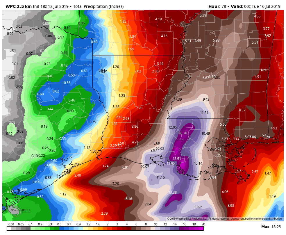
This morning I discussed the possibility of heavier rain potentially near Galveston or the Bay Area. Basically, we expect some type of inflow band, or an area of converging winds to setup near the coast tomorrow night and much of Sunday. If that happens, locally heavy rain will be possible, particularly along the immediate coast. The rainfall forecast above shows about 1 to 2 inches potentially near Galveston, with less as you come inland. We will have to refine this tomorrow a bit, just in case the heavier rains stay offshore or to our east, or alternatively look heavier over Galveston. For now, in Galveston, expect a forecast of persistent rains on Saturday night and Sunday with occasional showers or clouds inland from there. Saturday is probably a satisfactory beach day, but Sunday may be a loss. We will reassess how things look in the morning and offer you another update then.

Actually I had multiple browsers open, but I’ve mostly watched the geocolor and shortwave IR to see if the thunderstorms ever wrapped around the center – they never did. it’s got some great spin but this continues to be a disproportionate storm. Unless the center re-develops further south, a remote possibility mentioned by NHC reconnaissance, then it appears new orleans has dodged a bullet.
The browser loop was actually on my smartphone 🙂 but yes, it’s hard to ignore anything swirling like that. Thank you for the update, and for all the sensible information you provide!
When someone tries to get me all riled up about the weather, I just tell them “Space City Weather is the best information out there and they don’t fool around; what they do is tell the truth without the hype.” Thank you for all you do for us.
Wanna know how good these guys are? Check out their post from JULY 5TH https://spacecityweather.com/070519-quiet-summer-weekend-houston/#more-11002
Specifically, “At this time, the good news for Houston is that most reliable modeling shows this possible system staying mostly an issue for Louisiana and points east.”
Let’s support Matt and Eric. Click on a Reliant link every once in a while. I do and I believe they appreciate it!
It’s the biggest reason I continue to give Reliant my electricity business- they support this site.
Thanks again for giving us the skinny straight up. I finally got the wife to check out Space City Weather, after $200 worth of canned tuna and water, she chilled a bit. I’ll say it again…you were with us thru Harvey and we really appreciated it. Thanks for everything, you don’t know how much it helps to get real weather without the drama and unsubstantiated panic.
Bay Area Farmers Market is a rain or shine weekly market held on Sunday, 11-3, in the parking lot of Baybrook Mall. However, if the chance of thunderstorms and/or high wind is higher than 50% for the Bay Area Sunday, I’ll cancel the market. Therefore, I will look forward to your update Saturday morning! Thank you so much for always explaining even the most complicated meteorological events in ways I can understand what I need to understand! You guys are the best!
“the adorable cinnamon bun-esque swirl south of the Louisiana coast”
Not just no hype weather.
This is a poetically presented forecast.
Awesome!!
I’ve skipped watching the endless loops since I’ve found you guys. No need to needlessly worry, pay attention to every weather forecaster, and to go into panic mood with microscopic changes in the track. I figure if there were a change in the track that would impact the greater Houston area, I’d get an email update from you. You’ve earned my trust.