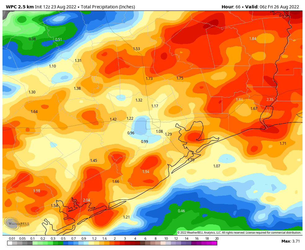
Good morning. Areas north of Interstate 10 saw some additional heavy rains during the overnight hours, but those showers have tapered off this morning. The atmosphere is fairly well worked over as a result, so things should be quiet this morning, and we’ve lifted our Stage 1 flood alert for the northern half of the metro area. But we’ll remain in a pattern favorable for the development of heavy rainfall through at least Wednesday. Additional rainfall totals for most areas should be manageable, at 1 to 3 inches, but we remain concerned about the potential for street flooding beneath downpours.
On the upside, these rains are putting a very nice dent into the region’s drought, and temperatures should continue to run at or below normal levels for the rest of August. This offers a nice reprieve after our record hot June and July.
Tuesday
Skies will be partly to mostly cloudy today, and this should help to hold high temperatures in the upper 80s to about 90 degrees for most of the area. I expect the radar to remain fairly calm this morning, but later this afternoon the potential for showers and thunderstorms will increase. Overall, however, this activity later today does not look too organized. Favored areas for heavy rain will, once again, be located north of Interstate 10 closer to a weak frontal boundary.
Wednesday
It still looks like Wednesday will produce the best chance of widespread rainfall for this week, with area-wide shower chances of 70 percent or higher. I think much of the region will pick up between 0.5 and 1.5 inches of rain on Wednesday. At this point it looks like shower chances will be greatest during the morning hours, so that may be something to watch for with Wednesday morning’s commute. With mostly cloudy skies expect highs to reach the upper 80s, for the most part.
Thursday and Friday
The chance for heavy rainfall will linger toward the end of the week, but we’re going to see conditions favoring such activity start to decrease as the upper atmosphere becomes less supportive. I’d say about 50 percent of the area will see rain each day. Highs probably will return to about 90 degrees, with a mix of daytime clouds and sunshine.
Saturday, Sunday, and beyond
The weekend should see partly to mostly sunny skies, with highs of around 90 degrees. Some decent 30 to 40 percent rain chances will linger on Saturday and Sunday, but at this point accumulations looks slight, and any showers that do form should pass fairly quickly.
Overall, next week, the atmosphere looks to remain unsettled in the absence of high pressure. Look for high temperatures to continue in the neighborhood of 90 degrees, with daily rain chances of 50 percent, or perhaps even a bit higher. We have no significant flooding concerns at this time.
Tropics
The National Hurricane Center continues to track a wave in the Atlantic that is moving westward. However, this wave is encountering a lot of dry air, and development this week is unlikely. Aside from that, things look fairly quiet for several days. However, by next week it does look as though things will start to kick off a bit more. We’ll need to watch the Caribbean Sea for potential activity, as well as additional tropical waves moving off the coast of Africa. Nevertheless, for late August, this is a great place to be when it comes to the Atlantic tropics.
Sustained swampy sogginess for the slow slog to September.
Nada here on the SE side last night.
Seems like EVERYONE is shouting “Wolf” I’ve only received almost an inch of rain over this entire ordeal, the most rain I’ve received on a single day is 1/2″!
We’ve had several days close to, or over, an inch.
why is there heavy rainfall forecasted and then there is none? lol
because forecasting weather is difficult to predict due to atmospheric changes silly rabbit
it’s been happening all summer though
I don’t get why everyone is so bent out of shape about not getting much or any rain the past few days, Eric and Matt said repeatedly the highest probability for heavier rainfall amounts would be north and northeast of I-10 and downtown, and they pretty much nailed it. I’m also pretty sure they’ve explained forecast rain percentages before… a 70% chance of rain does not mean it will rain 70% of the day in your own backyard, it’s not a guarantee, it’s an average for a given area, so 70% of that area may see rain while 30% will not, and if you didn’t get rain, guess what? you were part of that 30%. It also doesn’t mean the 70% who do get rain will receive the same amount, 10% may see nothing but a short-lived light shower the entire time, while another 10% somewhere else in the same area get flooded out of their homes.
forecasts everywhere have been predicting 80% probabilities all summer and we havent gotten much